Walton County, Florida
| Walton County, Florida | ||
|---|---|---|
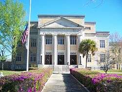
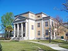 Walton County Courthouse | ||
| ||
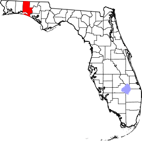 Location in the U.S. state of Florida | ||
 Florida's location in the U.S. | ||
| Founded | December 29, 1824 | |
| Seat | DeFuniak Springs | |
| Largest city | Miramar Beach | |
| Area | ||
| • Total | 1,240 sq mi (3,212 km2) | |
| • Land | 1,038 sq mi (2,688 km2) | |
| • Water | 202 sq mi (523 km2), 16.3% | |
| Population (est.) | ||
| • (2017) | 68,376[1] | |
| • Density | 66/sq mi (25/km2) | |
| Congressional district | 1st | |
| Time zone | Central: UTC−6/−5 | |
| Website |
www | |
Walton County is a county located in the state of Florida. As of the 2010 census, the population was 55,043.[2] Its county seat is DeFuniak Springs.[3] The county is home to the highest natural point in Florida: Britton Hill, at 345 feet (105 m).
Walton County is included in the Crestview-Fort Walton Beach-Destin, FL Metropolitan Statistical Area.
History
Walton County was created in 1824. It was named for Colonel George Walton, Jr., secretary of the Florida Territory from 1821 to 1826. Walton, the son of George Walton, a signer of the Declaration of Independence, was born 15 August 1786 in Augusta, Georgia, and died 20 March 1859 in Petersburg, Virginia.[4]
The county was settled in the early 18th century by Scots who migrated from the backcountry of the Carolinas. The original settlements were in the Euchee (Yuchi) Valley, near the landing on the Choctawhatchee River that was maintained by an Indian named Sam Story. These settlers founded one of the first Presbyterian churches in Northwest Florida. It is still an operating parish and has a historical cemetery.
Geography

According to the U.S. Census Bureau, the county has a total area of 1,240 square miles (3,200 km2), of which 1,038 square miles (2,690 km2) is land and 202 square miles (520 km2) (16.3%) is water.[5] The County is one of the largest in area in the state, stretching from the Alabama state line to the Emerald Coast.
Adjacent counties
- Covington County, Alabama - northwest
- Geneva County, Alabama - northeast
- Holmes County, Florida - east
- Washington County, Florida - east
- Bay County, Florida - southeast
- Okaloosa County, Florida - west
National protected areas
- Choctawhatchee National Forest (part)
- Point Washington State Forest (part)
Demographics
| Historical population | |||
|---|---|---|---|
| Census | Pop. | %± | |
| 1830 | 1,207 | — | |
| 1840 | 1,461 | 21.0% | |
| 1850 | 1,817 | 24.4% | |
| 1860 | 3,037 | 67.1% | |
| 1870 | 3,041 | 0.1% | |
| 1880 | 4,201 | 38.1% | |
| 1890 | 4,816 | 14.6% | |
| 1900 | 9,346 | 94.1% | |
| 1910 | 16,460 | 76.1% | |
| 1920 | 12,119 | −26.4% | |
| 1930 | 14,576 | 20.3% | |
| 1940 | 14,246 | −2.3% | |
| 1950 | 14,725 | 3.4% | |
| 1960 | 15,576 | 5.8% | |
| 1970 | 16,087 | 3.3% | |
| 1980 | 21,300 | 32.4% | |
| 1990 | 27,760 | 30.3% | |
| 2000 | 40,601 | 46.3% | |
| 2010 | 55,043 | 35.6% | |
| Est. 2017 | 68,376 | [6] | 24.2% |
| U.S. Decennial Census[7] 1790-1960[8] 1900-1990[9] 1990-2000[10] 2010-2015[2] | |||
As of the census[11] of 2000, there were 40,601 people, 16,548 households, and 11,120 families residing in the county. The population density was 38 people per square mile (15/km²). There were 29,083 housing units at an average density of 28 per square mile (11/km²). The racial makeup of the county was 88.41% White, 6.98% Black or African American, 1.28% Native American, 0.45% Asian, 0.04% Pacific Islander, 0.75% from other races, and 2.09% from two or more races. 2.17% of the population were Hispanic or Latino of any race.
There were 16,548 households out of which 26.40% had children under the age of 18 living with them, 53.00% were married couples living together, 10.10% had a female householder with no husband present, and 32.80% were non-families. 27.10% of all households were made up of individuals and 10.10% had someone living alone who was 65 years of age or older. The average household size was 2.35 and the average family size was 2.83.
In the county, the population was spread out with 21.70% under the age of 18, 7.10% from 18 to 24, 28.50% from 25 to 44, 26.90% from 45 to 64, and 15.80% who were 65 years of age or older. The median age was 40 years. For every 100 females there were 105.20 males. For every 100 females age 18 and over, there were 105.00 males.
The median income for a household in the county was $32,407, and the median income for a family was $37,663. Males had a median income of $26,799 versus $21,208 for females. The per capita income for the county was $18,198. About 11.60% of families and 14.40% of the population were below the poverty line, including 21.00% of those under age 18 and 10.90% of those age 65 or over.
Politics
| Year | Republican | Democratic | Other |
|---|---|---|---|
| 2016 | 75.98% 25,756 | 20.28% 6,876 | 3.73% 1,266 |
| 2012 | 75.19% 21,490 | 23.34% 6,671 | 1.47% 421 |
| 2008 | 72.08% 19,561 | 26.43% 7,174 | 1.49% 404 |
| 2004 | 73.22% 17,555 | 25.91% 6,213 | 0.87% 208 |
| 2000 | 66.51% 12,186 | 30.80% 5,643 | 2.70% 494 |
| 1996 | 49.68% 7,709 | 34.42% 5,342 | 15.90% 2,467 |
| 1992 | 42.25% 5,726 | 28.69% 3,888 | 29.07% 3,940 |
| 1988 | 69.30% 7,490 | 29.93% 3,235 | 0.77% 83 |
| 1984 | 74.01% 7,126 | 25.99% 2,503 | |
| 1980 | 50.28% 4,694 | 46.70% 4,360 | 3.02% 282 |
| 1976 | 35.35% 2,927 | 62.76% 5,196 | 1.88% 156 |
| 1972 | 85.93% 6,217 | 13.66% 988 | 0.41% 30 |
| 1968 | 13.45% 963 | 14.86% 1,064 | 71.70% 5,135 |
| 1964 | 60.51% 3,753 | 39.49% 2,449 | |
| 1960 | 28.95% 1,484 | 71.05% 3,642 | |
| 1956 | 33.24% 1,606 | 66.76% 3,225 | |
| 1952 | 29.48% 1,502 | 70.52% 3,593 | |
| 1948 | 17.16% 652 | 62.28% 2,366 | 20.56% 781 |
| 1944 | 21.15% 689 | 78.85% 2,569 | |
| 1940 | 17.74% 694 | 82.26% 3,217 | |
| 1936 | 15.51% 510 | 84.49% 2,778 | |
| 1932 | 10.96% 305 | 89.04% 2,477 | |
| 1928 | 61.36% 1,475 | 37.77% 908 | 0.87% 21 |
| 1924 | 18.77% 220 | 70.39% 825 | 10.84% 127 |
| 1920 | 30.66% 619 | 64.24% 1,297 | 5.10% 103 |
| 1916 | 37.14% 549 | 50.95% 753 | 11.91% 176 |
| 1912 | 7.01% 74 | 57.95% 612 | 35.04% 370 |
| 1908 | 37.96% 369 | 51.85% 504 | 10.19% 99 |
| 1904 | 42.65% 322 | 46.89% 354 | 10.46% 79 |
Libraries
Walton County has 4 branches, including the historic DeFuniak Springs Library.
- Coastal
- DeFuniak Springs
- Freeport
- Gladys N. Milton Memorial Library
Schools
The county is served by the Walton County School District.
- Bay Elementary, Santa Rosa Beach
- Emerald Coast Middle School, Santa Rosa Beach
- Freeport Elementary, Freeport
- Freeport High School, Freeport
- Freeport Middle School, Freeport
- Maude Saunders Elementary School, DeFuniak Springs
- Mossy Head Elementary, DeFuniak Springs
- Paxton School, Paxton
- Seaside School, Seaside
- South Walton High School, Santa Rosa Beach
- Van R. Butler Elementary, Santa Rosa Beach
- Walton Academy, DeFuniak Springs
- Walton High School, DeFuniak Springs
- Walton Middle School, DeFuniak Springs
- West DeFuniak Elementary, DeFuniak Springs
Communities
Cities
Town
Census-designated place
Other unincorporated communities
- Alys Beach
- Argyle
- Blue Mountain Beach
- Bruce
- Darlington
- Eucheanna (Euchee Valley)
- Glendale
- Grayton Beach
- Inlet Beach
- Mossy Head
- Red Bay
- Rosemary Beach
- Santa Rosa Beach
- Seacrest
- Seaside
Gallery
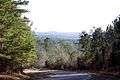 The hilly terrain of Walton County differs from most of the rest of Florida.
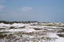 South Walton contains many neighborhoods nestled in sugary-white sand dunes.
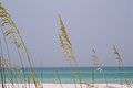 The coast of Walton County is fringed by emerald Gulf waters.
Transportation
Airports
Highways
- US highway 331
- US highway 90
- US highway 98
- State highway 20
- State highway 83
- Interstate 10
- State highway 30A
See also
References
- ↑ https://www.census.gov/quickfacts/fact/table/waltoncountyflorida/PST045216
- 1 2 "State & County QuickFacts". United States Census Bureau. Retrieved February 15, 2014.
- ↑ "Find a County". National Association of Counties. Retrieved June 7, 2011.
- ↑ Publications of the Florida Historical Society. Florida Historical Society. 1908. p. 34.
- ↑ "US Gazetteer files: 2010, 2000, and 1990". United States Census Bureau. February 12, 2011. Retrieved April 23, 2011.
- ↑ "Population and Housing Unit Estimates". Retrieved June 9, 2017.
- ↑ "U.S. Decennial Census". United States Census Bureau. Retrieved June 16, 2014.
- ↑ "Historical Census Browser". University of Virginia Library. Retrieved June 16, 2014.
- ↑ "Population of Counties by Decennial Census: 1900 to 1990". United States Census Bureau. Retrieved June 16, 2014.
- ↑ "Census 2000 PHC-T-4. Ranking Tables for Counties: 1990 and 2000" (PDF). United States Census Bureau. Retrieved June 16, 2014.
- ↑ "American FactFinder". United States Census Bureau. Retrieved May 14, 2011.
- ↑ Leip, David. "Dave Leip's Atlas of U.S. Presidential Elections". uselectionatlas.org. Retrieved 2018-06-16.
- ↑ Reference: http://uselectionatlas.org/RESULTS/datagraph.php?fips=12&year=1988&off=0&elect=0&f=0
External links
| Wikimedia Commons has media related to Walton County, Florida. |
Government links/Constitutional offices
- Walton County Board of County Commissioners
- Walton County Supervisor of Elections
- Walton County Property Appraiser
- Walton County Sheriff's Office
- Walton County Tax Collector
Special districts
Judicial branch
Media links
Places adjacent to Walton County, Florida | ||||||||||
|---|---|---|---|---|---|---|---|---|---|---|
| ||||||||||
Municipalities and communities of Walton County, Florida, United States | ||
|---|---|---|
| Cities | | |
| Town | ||
| CDP | ||
| Unincorporated communities | ||

| Topics |  Map of North Florida | |
|---|---|---|
| Counties | ||
| Major cities | ||
| Cities and towns 100k+ | ||
| Cities and towns 25k–100k | ||
| Cities and towns 10k–25k | ||
| Metro areas | ||
| Regions | ||