Kanksa
| Kanksa Kaksa | |
|---|---|
| Census Town | |
 Kanksa Location in West Bengal, India  Kanksa Kanksa (India) | |
| Coordinates: 23°28′16″N 87°27′16″E / 23.471199°N 87.454495°ECoordinates: 23°28′16″N 87°27′16″E / 23.471199°N 87.454495°E | |
| Country |
|
| State | West Bengal |
| District | Paschim Bardhaman |
| Population (2011) | |
| • Total | 23,789 |
| Languages | |
| • Official | Bengali, English |
| Time zone | UTC+5:30 (IST) |
| ISO 3166 code | IN-WB |
| Lok Sabha constituency | Bardhaman-Durgapur |
| Vidhan Sabha constituency | Galsi |
| Website |
bardhaman |
Kanksa is a census town in Kanksa CD Block in Durgapur subdivision of Paschim Bardhaman district in the Indian state of West Bengal. It is located near Panagarh.
History
Kanksa is home to one of the oldest police stations in the area. In 1847, when Raniganj was constituted as a separate subdivision of Bardhaman district, it had three police stations under its jurisdiction - Raniganj, Kanksa and Neamatpur.[1] The Shiva temple in Arra within Kanksa police station area is an old one of the "rekh deul" category.[2] There also is a suggestion that there possibly was an ancient city at this place.[3]
Geography
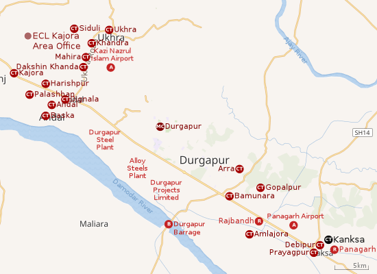 |
| Cities and towns in the southern portion of Durgapur subdivision in Paschim Bardhaman district MC: Municipal Corporation, CT: census town, R: rural centre, A: airport, B: barrage Owing to space constraints in the small map, the actual locations in a larger map may vary slightly |
Location
Kanksa is located at 23°28′16″N 87°27′16″E / 23.471199°N 87.454495°E.
The Asansol-Durgapur region is composed of undulating laterite soil. This area lies between two mighty rivers – the Damodar and the Ajay. They flow almost parallel to each other in the region – the average distance between the two rivers is around 30 km. The entire Durgapur-Kanksa-Faridpur-Ausgram area was densely forested even in more recent times. The influx of refugees from East Pakistan and their rehabilitation in the area, and irrigation facilities extended by Damodar Valley Corporation led to destruction of much of the forests in the area, but some still remain.[4]
Urbanisation
As per the 2011 census, 79.22% of the population of Durgapur subdivision was urban and 20.78% was rural. The sole municipal corporation in Durgapur subdivision is located at Durgapur and the subdivision has 38 (+1 partly) census towns (partly presented in the map alongside; all places marked on the map are linked in the full-screen map).[5]
Gram panchayats
Gram panchayats under Kanksa Panchayat Samiti are: Bidbihar, Molandighi, Gopalpur, Bonkati, Tilakchandrapur, Kanksa and Amlajore.[6]
Police station
Kanksa police station has jurisdiction over Kanksa CD Block. The area covered is 280 km2.[7][8] In the police set up Kanksa PS is under the Subdivisional Police Officer of Bardhaman Sadar North subdivision.[7]
Demographics
As per 2011 Census of India Kanksa had a total population of 23,789 of which 12,406 (52%) were males and 11,383 (48%) were females. Population below 6 years was 2,577. The total number of literates in Kanksa was 17,992 (84.82% of the population over 6 years).[9]
Transport
SH 14 passes through Kanksa. The Dubrajpur-Ilambazar sector of SH 14 is part of Panagarh–Morgram Highway.[10][11]
Education
Kanksa has six primary, one secondary and two higher secondary schools.[12]
References
- ↑ Chattopadhyay, Akkori, Bardhaman Jelar Itihas O Lok Sanskriti (History and Folk lore of Bardhaman District.), (in Bengali), Vol I, p 381, Radical Impression. ISBN 81-85459-36-3
- ↑ Chattopadhyay, Akkori, p. 251
- ↑ Chattopadhyay, Akkori, p. 7
- ↑ Chattopadhyay, Akkori, Bardhaman Jelar Itihas O Lok Sanskriti (History and Folk lore of Bardhaman District.), (in Bengali), Vol I, pp 14-15,38, 542 Radical Impression. ISBN 81-85459-36-3
- ↑ "District Statistical Handbook 2014 Burdwan". Table 2.2, 2.4(a). Department of Statistics and Programme Implementation, Government of West Bengal. Retrieved 15 September 2018.
- ↑ "List of Pradhan of Gram Panchayats, District: Bardhaman" (PDF). Government of West Bengal. Retrieved 2009-08-29.
- 1 2 "District Statistical Handbook 2014 Bardhaman". Tables 2.1, 2.2. Department of Statistics and Programme Implementation, Government of West Bengal. Retrieved 23 September 2018.
- ↑ "Burdwan District Police". Police Station. West Bengal Police. Retrieved 18 February 2017.
- ↑ "2011 Census – Primary Census Abstract Data Tables". West Bengal – District-wise. Registrar General and Census Commissioner, India. Retrieved 20 February 2017.
- ↑ "List of State Highways in West Bengal". West Bengal Traffic Police. Retrieved 23 February 2017.
- ↑ Google Maps
- ↑ 7th All-India School Education Survey 2003 Archived 2007-09-27 at the Wayback Machine.
Cities, towns and locations in Paschim Bardhaman district | |||||
|---|---|---|---|---|---|
| Cities, municipal and census towns | |||||
| Locations other than cities and towns |
| ||||
| Neighbourhoods in Asansol |
| ||||
| Related topics |
| ||||