Arra, Paschim Bardhaman
| Arra | |
|---|---|
| Census Town | |
 Arra Location in West Bengal, India  Arra Arra (India) | |
| Coordinates: 23°31′34″N 87°22′25″E / 23.526199°N 87.373495°ECoordinates: 23°31′34″N 87°22′25″E / 23.526199°N 87.373495°E | |
| Country |
|
| State | West Bengal |
| District | Paschim Bardhaman |
| Population (2011) | |
| • Total | 7,808 |
| Languages | |
| • Official | Bengali, English |
| Time zone | UTC+5:30 (IST) |
| Telephone code | 91 341 |
| Lok Sabha constituency | Bardhaman-Durgapur |
| Vidhan Sabha constituency | Durgapur Purba |
| Website |
bardhaman |
Arra is a census town in Kanksa CD Block in Durgapur subdivision of Paschim Bardhaman district in the Indian state of West Bengal.
Geography
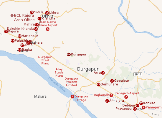 |
| Cities and towns in the southern portion of Durgapur subdivision in Paschim Bardhaman district MC: Municipal Corporation, CT: census town, R: rural centre, A: airport, B: barrage Owing to space constraints in the small map, the actual locations in a larger map may vary slightly |
Location
Arra is located at 23°31′34″N 87°22′25″E / 23.526199°N 87.373495°E.
Arra, Bamunara, Gopalpur and Amlajora form a cluster of census towns in the western portion of Kanksa CD Block.[1]
Urbanisation
As per the 2011 census, 79.22% of the population of Durgapur subdivision was urban and 20.78% was rural. The sole municipal corporation in Durgapur subdivision is located at Durgapur and the subdivision has 38 (+1 partly) census towns (partly presented in the map alongside; all places marked on the map are linked in the full-screen map).[2]
Demographics
As per the 2011 Census of India, Arra had a total population of 7,808 of which 3,953 (51%) were males and 3,855 (49%) were females. Population below 6 years was 791. The total number of literates in Arra was 5,982 (85.25% of the population over 6 years).[3]
Culture
Rarheswar Shiva temple has a unique architectural style. It was reportedly built to protect the village from the attack of Bhaskar Pandit, who was a worshipper of Shiva.[4]Bhaskar Pandit was one of the persons who led the Maratha invasions of Bengal in the 18th century.
References
- ↑ "District Census Handbook Bardhaman, Series 20, Part XII A, Census of India 2011" (PDF). Map of Kanksa CD Block, page 281. Directorate of Census Operations, West Bengal. Retrieved 7 September 2018.
- ↑ "District Statistical Handbook 2014 Burdwan". Table 2.2, 2.4(a). Department of Statistics and Programme Implementation, Government of West Bengal. Retrieved 15 September 2018.
- ↑ "2011 Census – Primary Census Abstract Data Tables". West Bengal – District-wise. Registrar General and Census Commissioner, India. Retrieved 12 September 2018.
- ↑ "District Census Handbook Bardhaman, Series 20, Part XII A, Census of India 2011" (PDF). Places of Archeological Interest, page 126. Directorate of Census Operations, West Bengal. Retrieved 12 September 2018.
Cities, towns and locations in Paschim Bardhaman district | |||||
|---|---|---|---|---|---|
| Cities, municipal and census towns | |||||
| Locations other than cities and towns |
| ||||
| Neighbourhoods in Asansol |
| ||||
| Related topics |
| ||||