Chinchuria
| Chinchuria Chichuria | |
|---|---|
| Census Town | |
 Chinchuria Location in West Bengal, India  Chinchuria Chinchuria (India) | |
| Coordinates: 23°42′44″N 87°11′20″E / 23.71219°N 87.188974°ECoordinates: 23°42′44″N 87°11′20″E / 23.71219°N 87.188974°E | |
| Country |
|
| State | West Bengal |
| District | Paschim Bardhaman |
| Population (2011) | |
| • Total | 6,617 |
| Languages | |
| • Official | Bengali, English |
| Time zone | UTC+5:30 (IST) |
| PIN | 713378 |
| Telephone code | 91 341 |
| Lok Sabha constituency | Asansol |
| Vidhan Sabha constituency | Jamuria |
| Website |
bardhaman |
Chinchuria is a census town in Jamuria CD Block in Asansol Sadar subdivision of Paschim Bardhaman district in the Indian state of West Bengal.
Geography
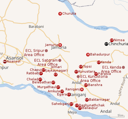 |
| Cities and towns in the eastern portion of Asansol Sadar subdivision in Paschim Bardhaman district MC: Municipal Corporation, CT: census town, N: neighbourhood, R: rural centre Owing to space constraints in the small map, the actual locations in a larger map may vary slightly |
Location
Chinchuria is located at 23°42′44″N 87°11′20″E / 23.71219°N 87.188974°E
Urbanisation
As per the 2011 census, 83.33% of the population of Asansol Sadar subdivision was urban and 16.67% was rural.[1]In 2015, the municipal areas of Kulti, Raniganj and Jamuria were included within the jurisdiction of Asansol Municipal Corporation.[2]Asansol Sadar subdivision has 26 (+1 partly) Census Towns.(partly presented in the map alongside; all places marked on the map are linked in the full-screen map).
Demographics
As per the 2011 Census of India, Chinchuria had a total population of 6,617 of which 3,458 (52%) were males and 3,159 (48%) were females. Population below 6 years was 691. The total number of literates in Chinchuria was 4,525 (76.36% of the population over 6 years).[3]
Economy
As per ECL website telephone numbers, operational collieries in the Kenda Area of Eastern Coalfields in 2018 are: Bahula Colliery, Chora Block Incline, CI Jambad Colliery, Chora OCP, Haripur Colliery, Lower Kenda Colliery, New Kenda Colliery, Siduli Colliery, SK OCP, West Kenda OCP.[4]
In Sonpur Bazari project located nearby, Seam R-IV is also referred to as Chinchuria seam.[5]
Education
Chinchuria has two primary and one higher secondary schools - Chinchuria Upendranath High School.[6]
References
- ↑ "District Statistical Handbook 2014 Burdwan". Table 2.2, 2.4(a). Department of Statistics and Programme Implementation, Government of West Bengal. Retrieved 4 September 2018.
- ↑ "The Kolkata Gazette" (PDF). Notification No. 335/MA/O/C-4/1M-36/2014 dated 3 June 2015. Department of Municipal Affairs, Government of West Bengal. Retrieved 4 September 2018.
- ↑ "2011 Census – Primary Census Abstract Data Tables". West Bengal – District-wise. Registrar General and Census Commissioner, India. Retrieved 27 August 2018.
- ↑ "Area wise Closed User Group (CUG) Telephone Numbers" (PDF). Kajora Area. Eastern Coalfields Limited. Retrieved 18 August 2018.
- ↑ "Name of Seam" (PDF). Eastern Coalfield Ltd. Retrieved 27 August 2018.
- ↑ 7th All-India School Education Survey 2003 Archived 2007-09-27 at the Wayback Machine.
Cities, towns and locations in Paschim Bardhaman district | |||||
|---|---|---|---|---|---|
| Cities, municipal and census towns | |||||
| Locations other than cities and towns |
| ||||
| Neighbourhoods in Asansol |
| ||||
| Related topics |
| ||||