Parasia
| Parasia | |
|---|---|
| Census Town | |
 Parasia Location in West Bengal, India  Parasia Parasia (India) | |
| Coordinates: 23°39′N 87°10′E / 23.65°N 87.16°ECoordinates: 23°39′N 87°10′E / 23.65°N 87.16°E | |
| Country |
|
| State | West Bengal |
| District | Paschim Bardhaman |
| Population (2011) | |
| • Total | 8,894 |
| Languages | |
| • Official | Bengali, English |
| Time zone | UTC+5:30 (IST) |
| ISO 3166 code | IN-WB |
| Vehicle registration | WB |
| Website |
wb |
Parasia is a census town in Jamuria CD Block and is served by Jamuria police station in Asansol Sadar subdivision of Paschim Bardhaman district in the Indian state of West Bengal.
Geography
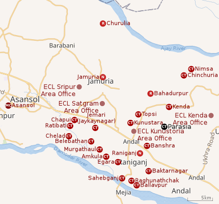 |
| Cities and towns in the eastern portion of Asansol Sadar subdivision in Paschim Bardhaman district MC: Municipal Corporation, CT: census town, N: neighbourhood, R: rural centre Owing to space constraints in the small map, the actual locations in a larger map may vary slightly |
Location
Parasia is at 23°39′N 87°10′E / 23.65°N 87.16°E.
Urbanisation
As per the 2011 census, 83.33% of the population of Asansol Sadar subdivision was urban and 16.67% was rural.[1]In 2015, the municipal areas of Kulti, Raniganj and Jamuria were included within the jurisdiction of Asansol Municipal Corporation.[2]Asansol Sadar subdivision has 26 (+1 partly) Census Towns.(partly presented in the map alongside; all places marked on the map are linked in the full-screen map).
Demographics
As per 2011 Census of India Parasia had a total population of 8,894 of which 4,794 (54%) were males and 4,100 (46%) were females. Population below 6 years was 1,194. The total number of literates in Parasia was 5,146 (66.83% of the population over 6 years).[3]
As of 2001 India census,[4] Parasia had a population of 8684. Males constitute 56% of the population and females 44%. Parasia has an average literacy rate of 55%, lower than the national average of 59.5%: male literacy is 65%, and female literacy is 42%. In Parasia, 14% of the population is under 6 years of age.
Economy
As per ECL website telephone numbers, operational collieries in the Kunustoria Area of Eastern Coalfields in 2018 are: Amritnagar Colliery, Amrasota Colliery, Bansra Colliery, Belbaid Colliery, Kunustoria Colliery, Mahabir OCP, North Searsole Colliery, Parasea Colliery, Parasea 6 & 7 Incline and Parasea OCP.[5]
References
- ↑ "District Statistical Handbook 2014 Burdwan". Table 2.2, 2.4(a). Department of Statistics and Programme Implementation, Government of West Bengal. Retrieved 4 September 2018.
- ↑ "The Kolkata Gazette" (PDF). Notification No. 335/MA/O/C-4/1M-36/2014 dated 3 June 2015. Department of Municipal Affairs, Government of West Bengal. Retrieved 4 September 2018.
- ↑ "2011 Census – Primary Census Abstract Data Tables". West Bengal – District-wise. Registrar General and Census Commissioner, India. Retrieved 18 February 2017.
- ↑ "Census of India 2001: Data from the 2001 Census, including cities, villages and towns (Provisional)". Census Commission of India. Archived from the original on 2004-06-16. Retrieved 2008-11-01.
- ↑ "Area wise Closed User Group (CUG) Telephone Numbers" (PDF). Kunustoria Area. Eastern Coalfields Limited. Retrieved 18 August 2018.
Cities, towns and locations in Paschim Bardhaman district | |||||
|---|---|---|---|---|---|
| Cities, municipal and census towns | |||||
| Locations other than cities and towns |
| ||||
| Neighbourhoods in Asansol |
| ||||
| Related topics |
| ||||