Bahula
| Bahula | |
|---|---|
| Census Town | |
 Bahula Location in West Bengal, India  Bahula Bahula (India) | |
| Coordinates: 23°39′27″N 87°11′46″E / 23.657419°N 87.195974°ECoordinates: 23°39′27″N 87°11′46″E / 23.657419°N 87.195974°E | |
| Country |
|
| State | West Bengal |
| District | Paschim Bardhaman |
| Population (2011) | |
| • Total | 17,510 |
| Languages | |
| • Official | Bengali, English |
| Time zone | UTC+5:30 (IST) |
| PIN | 713322 |
| Telephone code | 91 341 2666 |
| Lok Sabha constituency | Asansol |
| Vidhan Sabha constituency | Pandaveswar |
| Website |
bardhaman |
Bahula is a census town in Pandabeswar CD Block in Durgapur subdivision of Paschim Bardhaman district in the state of West Bengal, India.
Geography
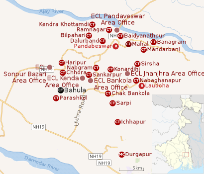 |
| Cities, towns and ECL Areas in the northern portion of Durgapur subdivision in Paschim Bardhaman district MC: Municipal Corporation, CT: census town, R: rural administrative centre Owing to space constraints in the small map, the actual locations in a larger map may vary slightly |
Location
Bahula is located at 23°39′27″N 87°11′46″E / 23.657419°N 87.195974°E.
The Asansol-Durgapur region is composed of undulating laterite soil. This area lies between two mighty rivers – the Damodar and the Ajay. They flow almost parallel to each other in the region – the average distance between the two rivers is around 30 km. For ages the area was heavily forested and infested with plunderers and marauders. The discovery of coal led to industrialisation of the area and most of the forests have been cleared.[1]
Konardihi, Nabgram, Chak Bankola, Sankarpur, Haripur, Bahula, Chhora and Parashkol form a cluster of census towns in the southern portion of Pandabeswar CD Block.[2]
Urbanisation
As per the 2011 census, 79.22% of the population of Durgapur subdivision was urban and 20.78% was rural. Durgapur subdivision has 1 municipal corporation at Durgapur and 38 (+1 partly) census towns (partly presented in the map alongside; all places marked on the map are linked in the full-screen map).[3]
Demographics
As per the 2011 Census of India Bahula had a total population of 17,510, of which 9,095 (52%) were males and 8,415 (48%) were females. Population below 6 years was 2,202. The total number of literates in Bahula was 11,445 (74.76% of the population over 6 years).[4]
As of 2001 India census,[5] Bahula had a population of 16,264. Males constitute 55% of the population and females 45%. Bahula has an average literacy rate of 58%, lower than the national average of 59.5%; with 64% of the males and 36% of females literate. 13% of the population is under 6 years of age.
Economy
This is a coal mining area. Bahula is part of Kenda Area of Eastern Coalfields Limited, a subsidiary of Coal India Limited. The area has been facing the problem of land subsidence.[6] There are some engineering workshops at Bahula.[7]
As per ECL website telephone numbers, operational collieries in the Kenda Area of Eastern Coalfields in 2018 are: Bahula Colliery, Chora Block Incline, CI Jambad Colliery, Chora OCP, Haripur Colliery, Lower Kenda Colliery, New Kenda Colliery, Siduli Colliery, SK OCP and West Kenda OCP.[8]
Education
Bahula has three primary and one higher secondary schools.[9]
Bahula Sashi Smriti High School is a co-educational higher secondary school.[10]
Healthcare
The 50-bed Regional Hospital of Eastern Coalfields is located at Bahula.[11]
References
- ↑ Chattopadhyay, Akkori, Bardhaman Jelar Itihas O Lok Sanskriti (History and Folk lore of Bardhaman District.), (in Bengali), Vol I, pp 14-15, Radical Impression. ISBN 81-85459-36-3
- ↑ "District Census Handbook Bardhaman, Series 20, Part XII A, Census of India 2011" (PDF). Map of Pandabeswar CD Block, page 243. Directorate of Census Operations, West Bengal. Retrieved 7 September 2018.
- ↑ "District Statistical Handbook 2014 Burdwan". Table 2.2, 2.4(a). Department of Statistics and Programme Implementation, Government of West Bengal. Retrieved 15 September 2018.
- ↑ "2011 Census – Primary Census Abstract Data Tables". West Bengal – District-wise. Registrar General and Census Commissioner, India. Retrieved 20 February 2017.
- ↑ "Census of India 2001: Data from the 2001 Census, including cities, villages and towns (Provisional)". Census Commission of India. Archived from the original on 2004-06-16. Retrieved 2008-11-01.
- ↑ Parliament Questions
- ↑ Chattopadhyay, Akkori, p 364
- ↑ "Area wise Closed User Group (CUG) Telephone Numbers" (PDF). Kajora Area. Eastern Coalfields Limited. Retrieved 18 August 2018.
- ↑ 7th All-India School Education Survey 2003 Archived 2007-09-27 at the Wayback Machine.
- ↑ "West Bengal Cuncil of Higher Secondary Education". Exam Venue. WBCHSE. Retrieved 29 July 2018.
- ↑ "Eastern Coalfields Limited's Hospitals" (PDF). ECL. Retrieved 23 April 2017.
Cities, towns and locations in Paschim Bardhaman district | |||||
|---|---|---|---|---|---|
| Cities, municipal and census towns | |||||
| Locations other than cities and towns |
| ||||
| Neighbourhoods in Asansol |
| ||||
| Related topics |
| ||||