Churulia
| Churulia | |
|---|---|
| Suburb of Asansol | |
 Churulia Location in West Bengal, India  Churulia Churulia (India) | |
| Coordinates: 23°47′N 87°05′E / 23.78°N 87.08°ECoordinates: 23°47′N 87°05′E / 23.78°N 87.08°E | |
| Country |
|
| State | West Bengal |
| District | Paschim Bardhaman |
| Elevation | 94 m (308 ft) |
| Demonym(s) | Asansolians / Asansolites/ Asansolbashi |
| Languages | |
| • Official | Bengali, English |
| Time zone | UTC+5:30 (IST) |
| Telephone code | 91 341 |
| Lok Sabha constituency | Asansol |
| Vidhan Sabha constituency | Jamuria |
| Website |
bardhaman |
Churulia is a suburb of Asansol under Jamuria block,[1] in Asansol Sadar subdivision of Paschim Bardhaman district in the state of West Bengal, India.
History
It is the birthplace of Bengali poet Kazi Nazrul Islam, and the resting place of his wife Pramila Devi. Many of the manuscripts, medallions and other belongings of the poet are preserved at Nazrul Academy in the village. Nearby, there is a college bearing the poet's name. A weeklong festival is held every year to celebrate the poet's birth anniversary. It is attended by leading cultural and literary figures from both India and Bangladesh. Nazrul Academy was established in 1958.[2]
It is believed that there was a fort at Churulia in olden days. It fell to Sher Khan, the Afghan chieftain in the 16th century.[3] A mound in the village is believed to contain the ruins of the fort.
During the Muslim rule a mosque was built at Churulia. It is a good example of Islamic architecture.[4]
Geography
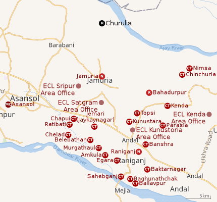 |
| Cities and towns in the eastern portion of Asansol Sadar subdivision in Paschim Bardhaman district MC: Municipal Corporation, CT: census town, N: neighbourhood, R: rural centre Owing to space constraints in the small map, the actual locations in a larger map may vary slightly |
Location
Churulia is located at 23°47′N 87°05′E / 23.78°N 87.08°E.[5] It has an average elevation of 94 metres (311 feet).
Churulia is located on the south bank of Ajay River.
Asansol is composed of undulating laterite region. This area lies between two mighty rivers – the Damodar and the Ajay. They flow almost parallel to each other in the region – the average distance between the two rivers is around 30 km. For ages the area was heavily forested and infested with plunderers and marauders. The discovery of coal led to industrialisation of the area and most of the forests have been cleared.[6]
Urbanisation
As per the 2011 census, 83.33% of the population of Asansol Sadar subdivision was urban and 16.67% was rural.[7]In 2015, the municipal areas of Kulti, Raniganj and Jamuria were included within the jurisdiction of Asansol Municipal Corporation.[8]Asansol Sadar subdivision has 26 (+1 partly) Census Towns.(partly presented in the map alongside; all places marked on the map are linked in the full-screen map).
Demographics
As per 2011 Census of India Churulia had a total population of 8,173 of which 4,203 (51%) were males and 3,970 (49%) were females. Population below 6 years was 1,286. The total number of literates in Churulia was 4,470 (64.70% of the population over 6 years).[9]
Economy
Churulia is situated in the heart of Raniganj Coalfield, one of India's coal mining areas.[10]
Transport
There are two minibus routes serving Churulia – one from Churulia to Asansol via Kalla and Domahani, and other from Churulia (Ajay Ghat) to Chittaranjan via Asansol and Chandrachur.[11]
Education
Kazi Nazrul Islam Mahavidyalaya was established in 1981 at Churulia. It is affiliated with Kazi Nazrul University. It offers honours courses in Bengali, Hindi, English, history, geography, political science and B.Com.[12]
Healthcare
References
- ↑ Villages in Bardhaman District Archived 2007-02-05 at the Wayback Machine.
- ↑ The Statesman 8 February 2007 Archived 29 September 2007 at the Wayback Machine.
- ↑ Chattopadhyay, Akkori, Bardhaman Jelar Itihas O Lok Sanskriti (History and Folk lore of Bardhaman District.), (in Bengali) , Vol I, p 181, Radical Impression. ISBN 81-85459-36-3
- ↑ Chattopadhyay, Akkori, p 249
- ↑ Falling Rain Genomics, Inc - Churulia
- ↑ Chattopadhyay, Akkori, pp 14-15
- ↑ "District Statistical Handbook 2014 Burdwan". Table 2.2, 2.4(a). Department of Statistics and Programme Implementation, Government of West Bengal. Retrieved 4 September 2018.
- ↑ "The Kolkata Gazette" (PDF). Notification No. 335/MA/O/C-4/1M-36/2014 dated 3 June 2015. Department of Municipal Affairs, Government of West Bengal. Retrieved 4 September 2018.
- ↑ "2011 Census – Primary Census Abstract Data Tables". West Bengal – District-wise. Registrar General and Census Commissioner, India. Retrieved 18 February 2017.
- ↑ Chattopadhyay, Akkori, p 48
- ↑ Minbus Permit Register Archived 2007-09-27 at the Wayback Machine.
- ↑ "Kazi Nazrul Islam Mahavidyalaya". KNIM. Retrieved 2 March 2017.
- ↑ "Bardhaman district". Medical Institutions. Bardhaman district administration. Retrieved 6 March 2017.
- ↑ "2011 District Census Handbook Bardhaman Part XII A" (PDF). Jamuria Block Map on page 189. Directorate of Census Operations, West Bengal. Retrieved 6 March 2017.
External links

- Satellite view
Cities, towns and locations in Paschim Bardhaman district | |||||
|---|---|---|---|---|---|
| Cities, municipal and census towns | |||||
| Locations other than cities and towns |
| ||||
| Neighbourhoods in Asansol |
| ||||
| Related topics |
| ||||