Panagarh
| Panagarh | |
|---|---|
| Village | |
 Panagarh railway station | |
 Panagarh Location in West Bengal, India  Panagarh Panagarh (India) | |
| Coordinates: 23°26′54″N 87°28′10″E / 23.4484°N 87.4694°ECoordinates: 23°26′54″N 87°28′10″E / 23.4484°N 87.4694°E | |
| Country |
|
| State | West Bengal |
| District | Paschim Bardhaman |
| Elevation | 58 m (190 ft) |
| Population (2011) | |
| • Total | 5,510 |
| Languages | |
| • Official | Bengali, English |
| Time zone | UTC+5:30 (IST) |
| Vehicle registration | WB |
| Lok Sabha constituency | Bardhaman-Durgapur |
| Vidhan Sabha constituency | Galsi |
| Website |
bardhaman |
Panagarh is the easternmost suburb of Durgapur, identified in 2011 census as a village in Kanksa CD Block in Durgapur subdivision of Paschim Bardhaman district of West Bengal.
Geography
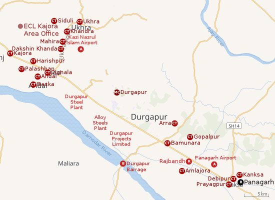 |
| Cities and towns in the southern portion of Durgapur subdivision in Paschim Bardhaman district MC: Municipal Corporation, CT: census town, R: rural centre, A: airport, B: barrage Owing to space constraints in the small map, the actual locations in a larger map may vary slightly |
Location
Panagarh is located at 23°27′N 87°26′E / 23.45°N 87.43°E.[1] It has an average elevation of 58 m (190 ft).
The Asansol-Durgapur region is composed of undulating laterite soil. This area lies between two mighty rivers – the Damodar and the Ajay. They flow almost parallel to each other in the region – the average distance between the two rivers is around 30 km. The entire Durgapur-Kanksa-Faridpur-Ausgram area was densely forested even in more recent times. The influx of refugees from East Pakistan and their rehabilitation in the area, and irrigation facilities extended by Damodar Valley Corporation led to destruction of much of the forests in the area, but some still remain.[2]
Urbanisation
As per the 2011 census, 79.22% of the population of Durgapur subdivision was urban and 20.78% was rural. The sole municipal corporation in Durgapur subdivision is located at Durgapur and the subdivision has 38 (+1 partly) census towns (partly presented in the map alongside; all places marked on the map are linked in the full-screen map).[3]
Indian Air Force base
Panagarh Airport was constructed in 1944, during the Second World War. It serves as a base for the Indian Air Force. In 2016, it was renamed as Air Force Station Arjan Singh.[4]
Cantonment
One of the 62 cantonments in the country is located at Panagarh.[5]
Demographics
As per the 2011 Census of India Panagar had a total population of 5,510, of which 2,796 (51%) were males and 2,714 (49%) were females. Population below 6 years was 650. The total number of literates in Panagar was 3,836 (78.93% of the population over 6 years).[6]
Transport
Panagarh is a station on the Bardhaman-Asansol section, which is a part of Howrah-Gaya-Delhi line, Howrah-Allahabad-Mumbai line and Howrah-Delhi main line.[7]
Earlier, NH 19 passed through Panagarh Bazar. A bypass was constructed in 2016, avoiding the crowded bazar area. The old Grand Trunk Road continues to pass through the town.[8]
SH 14 passes through Panagarh. The Dubrajpur-Panagarh sector of SH 14 is part of Panagarh–Morgram Highway.[9][10]
Education
Panagarh has five primary schools, Rama Krishna Ashrama Vidyapitha, the Kendriya Vidyalaya, Secondary School (Panagarh Railway Colony School) and two higher secondary schools (Panagarh Bazar Hindi High School and Kanksha High School).[11]
Professional Education
Panagarh has two engineering colleges viz. Aryabhatta Institute of Engineering & Management Durgapur[12] and Techno India, Durgapur.
Healthcare
There is a block primary health centre at Panagarh.[13]
References
- ↑ Falling Rain Genomics, Inc – Panagarh. Fallingrain.com. Retrieved on 2012-03-23.
- ↑ Chattopadhyay, Akkori, Bardhaman Jelar Itihas O Lok Sanskriti (History and Folk lore of Bardhaman District.), (in Bengali), Vol I, pp 14-15,38, 542 Radical Impression. ISBN 81-85459-36-3
- ↑ "District Statistical Handbook 2014 Burdwan". Table 2.2, 2.4(a). Department of Statistics and Programme Implementation, Government of West Bengal. Retrieved 15 September 2018.
- ↑ "Panagarh airbase renamed after former IAF chief Arjan Singh". News, National. The Hindu, 15 April 2016. Retrieved 20 February 2017.
- ↑ "Indian Army Facilities". Global Security.org. Retrieved 20 February 2017.
- ↑ "2011 Census – Primary Census Abstract Data Tables". West Bengal – District-wise. Registrar General and Census Commissioner, India. Retrieved 20 February 2017.
- ↑ "63509 Bardhaman-Asansol MEMU". Time Table. indiarailinfo. Retrieved 9 February 2017.
- ↑ "Political race to open road". The Telegraph, 11 December 2016. Retrieved 20 February 2017.
- ↑ "List of State Highways in West Bengal". West Bengal Traffic Police. Retrieved 23 February 2017.
- ↑ Google Maps
- ↑ All India Education Survey 2003. National Informatics Centre (Burdwan District Unit), Department of Information Technology, Ministry of Communications and Information Technology, India. bardhaman.gov.in,
- ↑ Welcome to AIEMD: HOME. Aiemd.org. Retrieved on 2012-03-23.
- ↑ "Bardhaman district". Medical Institutions. Bardhaman district administration. Retrieved 6 March 2017.
Cities, towns and locations in Paschim Bardhaman district | |||||
|---|---|---|---|---|---|
| Cities, municipal and census towns | |||||
| Locations other than cities and towns |
| ||||
| Neighbourhoods in Asansol |
| ||||
| Related topics |
| ||||