Majiara
| Majiara | |
|---|---|
| Census Town | |
 Majiara Location in West Bengal, India  Majiara Majiara (India) | |
| Coordinates: 23°43′30″N 87°01′03″E / 23.724944°N 87.017611°ECoordinates: 23°43′30″N 87°01′03″E / 23.724944°N 87.017611°E | |
| Country |
|
| State | West Bengal |
| District | Paschim Bardhaman |
| Population (2011) | |
| • Total | 5,444 |
| Languages | |
| • Official | Bengali, English |
| Time zone | UTC+5:30 (IST) |
| PIN | 713330 (Majhiara) |
| Telephone code | 91 341 |
| Lok Sabha constituency | Asansol |
| Vidhan Sabha constituency | Barabani |
| Website |
bardhaman |
Majiara is a census town in Barabani CD Block in Asansol Sadar subdivision of Paschim Bardhaman district in the Indian state of West Bengal.
Geography
Location
Majiara is located at 23°43′30″N 87°01′03″E / 23.724944°N 87.017611°E
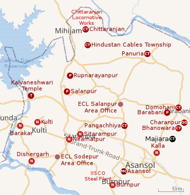 |
| Cities, towns and ECL Areas in the western portion of Asansol Sadar subdivision in Paschim Bardhaman district MC: municipal corporation, P: rural administrative centre, CT: census town, N: neighbourhood, OG: out growth, T: temple Owing to space constraints in the small map, the actual locations in a larger map may vary slightly |
The Asansol-Durgapur region is composed of undulating laterite soil. This area lies between two mighty rivers – the Damodar and the Ajay. They flow almost parallel to each other in the region – the average distance between the two rivers is around 30 km. For ages the area was heavily forested and infested with plunderers and marauders. The discovery of coal in the 18th century led to industrialisation of the area and most of the forests have been cleared.[1]
Pangachhiya, Majiara, Bhanowara, Domohani, Charanpur (OG), Ratibati and Chelad form a cluster of census towns and an outgrowth on the northern and eastern sides of Asansol.[2]
Urbanisation
As per the 2011 census, 83.33% of the population of Asansol Sadar subdivision was urban and 16.67% was rural.[3]In 2015, the municipal areas of Kulti, Raniganj and Jamuria were included within the jurisdiction of Asansol Municipal Corporation.[4]Asansol Sadar subdivision has 26 (+1 partly) Census Towns.(partly presented in the map alongside; all places marked on the map are linked in the full-screen map).
Demographics
As per the 2011 Census of India, Majiara had a total population of 5,444 of which 2,813 (52%) were males and 2,631 (48%) were females. Population below 6 years was 721. The total number of literates in Majiara was 3,341 (70,74% of the population over 6 years).[5]
As per the 2011 census, the urban agglomeration (UA) centred upon Asansol had a population of 1,243,414. In addition to the erstwhile municipalities of Kulti, Jamuria, and Raniganj subsequently incorporated into the Asansol Municipal Corporation, the agglomeration included the census towns of Amkula, Baktarnagar, Ballavpur, Bhanowara, Domohani, Egara, Jemari (J.K. Nagar Township), Majiara, Murgathaul, Raghunathchak, Sahebganj and Topsi, and also Charanpur, an outgrowth of Jamuria.[6][4]
References
- ↑ Chattopadhyay, Akkori, Bardhaman Jelar Itihas O Lok Sanskriti (History and Folk lore of Bardhaman District.), (in Bengali), Vol I, pp 14-15, Radical Impression. ISBN 81-85459-36-3
- ↑ "Census of India 2011, West Bengal: District Census Handbook, Barddhaman" (PDF). Map of Barabani CD Block, page 167 and Map of Raniganj CD Block, page 215. Directorate of Census Operations, West Bengal. Retrieved 31 August 2018.
- ↑ "District Statistical Handbook 2014 Burdwan". Table 2.2, 2.4(a). Department of Statistics and Programme Implementation, Government of West Bengal. Retrieved 4 September 2018.
- 1 2 "The Kolkata Gazette" (PDF). Notification No. 335/MA/O/C-4/1M-36/2014 dated 3 June 2015. Department of Municipal Affairs, Government of West Bengal. Retrieved 4 September 2018.
- ↑ "2011 Census – Primary Census Abstract Data Tables". West Bengal – District-wise. Registrar General and Census Commissioner, India. Retrieved 31 August 2018.
- ↑ "Constituents of Urban Agglomerations having population 1 lakh and above" (PDF). Provisional Population Total, Census of India 2011. Government of India. Retrieved 27 August 2018.
Cities, towns and locations in Paschim Bardhaman district | |||||
|---|---|---|---|---|---|
| Cities, municipal and census towns | |||||
| Locations other than cities and towns |
| ||||
| Neighbourhoods in Asansol |
| ||||
| Related topics |
| ||||