Debipur, India
| Debipur | |
|---|---|
| Census Town | |
 Debipur Location in West Bengal, India  Debipur Debipur (India) | |
| Coordinates: 23°27′22.7″N 87°27′14.0″E / 23.456306°N 87.453889°ECoordinates: 23°27′22.7″N 87°27′14.0″E / 23.456306°N 87.453889°E | |
| Country |
|
| State | West Bengal |
| District | Paschim Bardhaman |
| Government | |
| • Type | Municipal corporation |
| • Body | Nagar Palika |
| Elevation | 19 m (62 ft) |
| Population (2011) | |
| • Total | 9,967 |
| Languages | |
| • Official | Bengali, English |
| Time zone | UTC+5:30 (IST) |
| Vehicle registration | WB |
| Website |
bardhaman |
Debipur is a census town in Kanksa CD Block of Durgapur subdivision in Paschim Bardhaman district in the state of West Bengal, India.
Geography
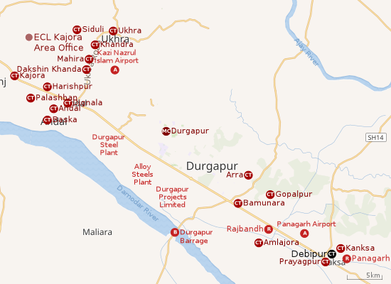 |
| Cities and towns in the southern portion of Durgapur subdivision in Paschim Bardhaman district MC: Municipal Corporation, CT: census town, R: rural centre, A: airport, B: barrage Owing to space constraints in the small map, the actual locations in a larger map may vary slightly |
Location
The Asansol-Durgapur region is composed of undulating laterite soil. This area lies between two mighty rivers – the Damodar and the Ajay. They flow almost parallel to each other in the region – the average distance between the two rivers is around 30 km. The entire Durgapur-Kanksa-Faridpur-Ausgram area was densely forested even in more recent times. The influx of refugees from East Pakistan and their rehabilitation in the area, and irrigation facilities extended by Damodar Valley Corporation led to destruction of much of the forests in the area, but some still remain.[1]
Urbanisation
As per the 2011 census, 79.22% of the population of Durgapur subdivision was urban and 20.78% was rural. The sole municipal corporation in Durgapur subdivision is located at Durgapur and the subdivision has 38 (+1 partly) census towns (partly presented in the map alongside; all places marked on the map are linked in the full-screen map).[2]
Demographics
As per the 2011 Census of India Debipur had a total population of 9,967, of which 5,064 (51%) were males and 4,903 (49%) were females. Population below 6 years was 1,084. The total number of literates in Debipur was 7,402 (83.33% of the population over 6 years).[3]
As of 2001 India census,[4] Debipur had a population of 9115. Males constitute 52% of the population and females 48%. Debipur has an average literacy rate of 68%, higher than the national average of 59.5%: male literacy is 75% and, female literacy is 60%. In Debipur, 12% of the population is under 6 years of age.
Transport
References
- ↑ Chattopadhyay, Akkori, Bardhaman Jelar Itihas O Lok Sanskriti (History and Folk lore of Bardhaman District.), (in Bengali), Vol I, pp 14-15,38, 542 Radical Impression. ISBN 81-85459-36-3
- ↑ "District Statistical Handbook 2014 Burdwan". Table 2.2, 2.4(a). Department of Statistics and Programme Implementation, Government of West Bengal. Retrieved 15 September 2018.
- ↑ "2011 Census – Primary Census Abstract Data Tables". West Bengal – District-wise. Registrar General and Census Commissioner, India. Retrieved 20 February 2017.
- ↑ "Census of India 2001: Data from the 2001 Census, including cities, villages and towns (Provisional)". Census Commission of India. Archived from the original on 2004-06-16. Retrieved 2008-11-01.
- ↑ "List of State Highways in West Bengal". West Bengal Traffic Police. Retrieved 23 February 2017.
- ↑ Google Maps
Cities, towns and locations in Paschim Bardhaman district | |||||
|---|---|---|---|---|---|
| Cities, municipal and census towns | |||||
| Locations other than cities and towns |
| ||||
| Neighbourhoods in Asansol |
| ||||
| Related topics |
| ||||