Kunustara
| Kunustara | |
|---|---|
| Census Town | |
 Kunustara Location in West Bengal, India  Kunustara Kunustara (India) | |
| Coordinates: 23°39′28″N 87°07′03″E / 23.657711°N 87.117422°ECoordinates: 23°39′28″N 87°07′03″E / 23.657711°N 87.117422°E | |
| Country |
|
| State | West Bengal |
| District | Paschim Bardhaman |
| Population (2011) | |
| • Total | 5,127 |
| Languages | |
| • Official | Bengali, English |
| Time zone | UTC+5:30 (IST) |
| Vehicle registration | WB |
| Website |
bardhaman |
Kunustara is a census town in Jamuria CD Block and is served by Jamuria police station in Asansol Sadar subdivision of Paschim Bardhaman district in the Indian state of West Bengal.
Geography
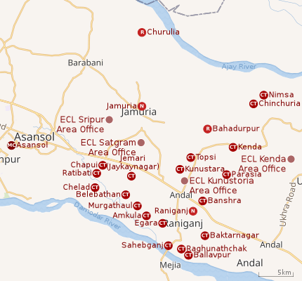 |
| Cities and towns in the eastern portion of Asansol Sadar subdivision in Paschim Bardhaman district MC: Municipal Corporation, CT: census town, N: neighbourhood, R: rural centre Owing to space constraints in the small map, the actual locations in a larger map may vary slightly |
Location
Kunustara is located at 23°39′28″N 87°07′03″E / 23.657711°N 87.117422°E.
The Asansol-Durgapur region is composed of undulating laterite soil. This area lies between two mighty rivers – the Damodar and the Ajay. They flow almost parallel to each other in the region – the average distance between the two rivers is around 30 km. For ages the area was heavily forested and infested with plunderers and marauders. The discovery of coal led to industrialisation of the area and most of the forests have been cleared.[1]
Urbanisation
As per the 2011 census, 83.33% of the population of Asansol Sadar subdivision was urban and 16.67% was rural.[2]In 2015, the municipal areas of Kulti, Raniganj and Jamuria were included within the jurisdiction of Asansol Municipal Corporation.[3]Asansol Sadar subdivision has 26 (+1 partly) Census Towns.(partly presented in the map alongside; all places marked on the map are linked in the full-screen map).
Demographics
As per 2011 Census of India Kunustara had a total population of 5,127 of which 2,720 (53%) were males and 2,407 (47%) were females. Population below 6 years was 587. The total number of literates in Kunustara was 3,451 (76.01% of the population over 6 years).[4]
As of 2001 India census,[5] Kunustara had a population of 5,416. Males constitute 56% of the population and females 44%. Kunustara has an average literacy rate of 67%, higher than the national average of 59.5%: male literacy is 77%, and female literacy is 55%. In Kunustara, 13% of the population is under 6 years of age.
Economy
As per ECL website telephone numbers, operational collieries in the Kunustoria Area of Eastern Coalfields in 2018 are: Amritnagar Colliery, Amrasota Colliery, Bansra Colliery, Belbaid Colliery, Kunustoria Colliery, Mahabir OCP, North Searsole Colliery, Parasea Colliery, Parasea 6 & 7 Incline and Parasea OCP.[6]
Education
Kunustara has two primary schools.[7]
References
- ↑ Chattopadhyay, Akkori, Bardhaman Jelar Itihas O Lok Sanskriti (History and Folk lore of Bardhaman District.), (in Bengali), Vol I, pp 14-15, Radical Impression. ISBN 81-85459-36-3
- ↑ "District Statistical Handbook 2014 Burdwan". Table 2.2, 2.4(a). Department of Statistics and Programme Implementation, Government of West Bengal. Retrieved 4 September 2018.
- ↑ "The Kolkata Gazette" (PDF). Notification No. 335/MA/O/C-4/1M-36/2014 dated 3 June 2015. Department of Municipal Affairs, Government of West Bengal. Retrieved 4 September 2018.
- ↑ "2011 Census – Primary Census Abstract Data Tables". West Bengal – District-wise. Registrar General and Census Commissioner, India. Retrieved 18 February 2017.
- ↑ "Census of India 2001: Data from the 2001 Census, including cities, villages and towns (Provisional)". Census Commission of India. Archived from the original on 2004-06-16. Retrieved 2008-11-01.
- ↑ "Area wise Closed User Group (CUG) Telephone Numbers" (PDF). Kunustoria Area. Eastern Coalfields Limited. Retrieved 18 August 2018.
- ↑ 7th All-India School Education Survey 2003 Archived 2007-09-27 at the Wayback Machine.
Cities, towns and locations in Paschim Bardhaman district | |||||
|---|---|---|---|---|---|
| Cities, municipal and census towns | |||||
| Locations other than cities and towns |
| ||||
| Neighbourhoods in Asansol |
| ||||
| Related topics |
| ||||