Ukhra
| Ukhra | |
|---|---|
| Census Town | |
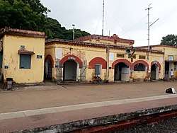 Ukhra railway station | |
 Ukhra Location in West Bengal, India  Ukhra Ukhra (India) | |
| Coordinates: 23°39′14″N 87°14′35″E / 23.654°N 87.243°ECoordinates: 23°39′14″N 87°14′35″E / 23.654°N 87.243°E | |
| Country |
|
| State | West Bengal |
| District | Paschim Bardhaman |
| Population (2011) | |
| • Total | 24,104 |
| Languages | |
| • Official | Bengali, English |
| Time zone | UTC+5:30 (IST) |
| Lok Sabha constituency | Asansol |
| Vidhan Sabha constituency | Raniganj |
| Website |
bardhaman |
Ukhra is a census town in Andal CD Block in Durgapur subdivision of Paschim Bardhaman district in the Indian state of West Bengal.
Geography
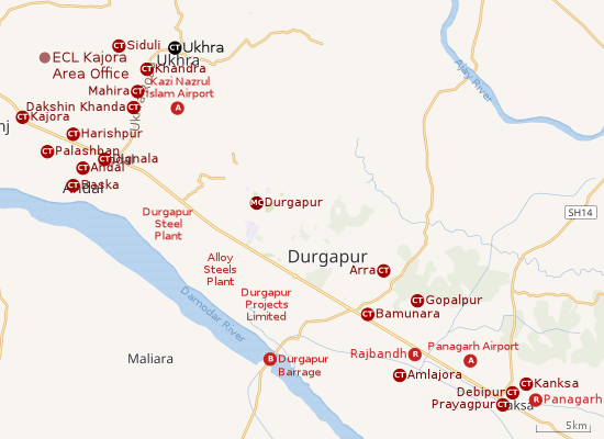 |
| Cities and towns in the southern portion of Durgapur subdivision in Paschim Bardhaman district MC: Municipal Corporation, CT: census town, R: rural centre, A: airport, B: barrage Owing to space constraints in the small map, the actual locations in a larger map may vary slightly |
Location
Ukhra is located at 23°39′14″N 87°14′35″E / 23.654°N 87.243°E.
Ukhra is a census town in Andal (community development block), as per Serial No. 237 of Towns/ Villages in the Bardhaman district section of 2011 census data and also the Map of CD Block Ondal on Page 229 of District Census Handbook for Bardhaman District.
The Asansol-Durgapur region is composed of undulating laterite soil. This area lies between the Damodar and the Ajay rivers. The discovery of coal in the 18th century led to industrialization of the area and most of the forests have been cleared.[1]
Urbanisation
As per the 2011 census, 79.22% of the population of Durgapur subdivision was urban and 20.78% was rural. The sole municipal corporation in Durgapur subdivision is located at Durgapur and the subdivision has 38 (+1 partly) census towns (partly presented in the map above; all places marked on the map are linked in the full-screen map).[2]
Siduli, Khandra, Ukhra, Mahira, Dakshin Khanda, Harishpur, Kajora, a part of Andal (gram), (all in Andal CD Block), Parashkol (partly in Pandabeswar CD Block and partly in Andal CD Block) and Chak Bankola (partly in Pandabeswar CD Block and partly in Andal CD Block), lying north of NH 19 (old numbering NH 2)/ Grand Trunk Road form a cluster of census towns. This cluster is linked with two more clusters of census towns – one located south of NH 19 in Andal CD Block and another lying in Pandabeswar CD Block.[3]
Demographics
As per 2011 Census of India Ukhra had a total population of 24,104 of which 12,500 (52%) were males and 11,604 (48%) were females. Population below 6 years was 2,489. The total number of literates in Ukhra was 17,591 (81.38% of the population over 6 years).[4]
As of 2001 India census,[5] Ukhra had a population of 19,868. Males constitute 53% of the population and females 47%. Ukhra has an average literacy rate of 69%, higher than the national average of 59.5%: male literacy is 76%, and female literacy is 61%. In Ukhra, 11% of the population is under 6 years of age.
Transport
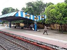
Ukhra railway station is 12 km from Andal on the Andal-Sainthia Branch Line of Eastern Railway.[6]
Healthcare
The 50-bed Bankola Area Hospital of Eastern Coalfields is located at Ukhra.[7]
References
- ↑ Chattopadhyay, Akkori, Bardhaman Jelar Itihas O Lok Sanskriti (History and Folk lore of Bardhaman District.), (in Bengali), Vol I, pp 14-15, Radical Impression. ISBN 81-85459-36-3
- ↑ "District Statistical Handbook 2014 Burdwan". Table 2.2, 2.4(a). Department of Statistics and Programme Implementation, Government of West Bengal. Retrieved 15 September 2018.
- ↑ "District Census Handbook Bardhaman, Series 20, Part XII A, Census of India 2011" (PDF). Map of Ondal CD Block, page 229. Directorate of Census Operations, West Bengal. Retrieved 16 September 2018.
- ↑ "2011 Census – Primary Census Abstract Data Tables". West Bengal – District-wise. Registrar General and Census Commissioner, India. Retrieved 20 February 2017.
- ↑ "Census of India 2001: Data from the 2001 Census, including cities, villages and towns (Provisional)". Census Commission of India. Archived from the original on 2004-06-16. Retrieved 2008-11-01.
- ↑ Eastern Railway time table
- ↑ "Eastern Coalfields Limited's Hospitals" (PDF). ECL. Retrieved 23 April 2017.
External links
Cities, towns and locations in Paschim Bardhaman district | |||||
|---|---|---|---|---|---|
| Cities, municipal and census towns | |||||
| Locations other than cities and towns |
| ||||
| Neighbourhoods in Asansol |
| ||||
| Related topics |
| ||||