Banagram, Paschim Bardhaman
| Banagram | |
|---|---|
| Census Town | |
 Banagram Location in West Bengal, India  Banagram Banagram (India) | |
| Coordinates: 23°42′55″N 87°19′27″E / 23.715252°N 87.324069°ECoordinates: 23°42′55″N 87°19′27″E / 23.715252°N 87.324069°E | |
| Country |
|
| State | West Bengal |
| District | Paschim Bardhaman |
| Population (2011) | |
| • Total | 5,635 |
| Languages | |
| • Official | Bengali, English |
| Time zone | UTC+5:30 (IST) |
| PIN | 713381 (Banagram) |
| Telephone code | 91 341 |
| Lok Sabha constituency | Asansol |
| Vidhan Sabha constituency | Pandaveswar |
| Website |
bardhaman |
Banagram is a census town in Faridpur Durgapur CD Block in Durgapur subdivision of Paschim Bardhaman district in the Indian state of West Bengal.
Geography
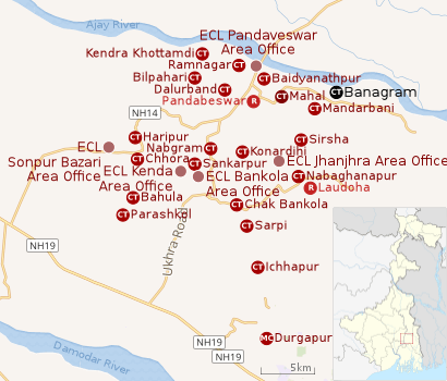 |
| Cities, towns and ECL Areas in the northern portion of Durgapur subdivision in Paschim Bardhaman district MC: Municipal Corporation, CT: census town, R: rural administrative centre Owing to space constraints in the small map, the actual locations in a larger map may vary slightly |
Location
Banagram is located at 23°42′55″N 87°19′27″E / 23.715252°N 87.324069°E.
The Asansol-Durgapur region is composed of undulating laterite region. This area lies between two mighty rivers – the Damodar and the Ajay. They flow almost parallel to each other in the region – the average distance between the two rivers is around 30 km. For ages the area was heavily forested and infested with plunderers and marauders. The discovery of coal in the 18th century led to industrialisation of the area and most of the forests have been cleared.[1]
Banagram, Mandarbani, Sirsha, Nabaghanapur, Sarpi and Ichhapur form a series of census towns along the western border of Faridpur-Durgapur CD Block.[2]
Urbanisation
As per the 2011 census, 79.22% of the population of Durgapur subdivision was urban and 20.78% was rural. Durgapur subdivision has 1 municipal corporation at Durgapur and 38 (+1 partly) census towns (partly presented in the map alongside; all places marked on the map are linked in the full-screen map).[3]
Demographics
As per the 2011 Census of India, Banagram had a total population of 5,635 of which 2,938 (52%) were males and 2,697 (48%) were females. Population below 6 years was 666. The total number of 1literates in Banagram was 3,431 (69.05% of the population over 6 years).[4]
Economy
As per ECL website telephone numbers, operational collieries in the Pandaveswar Area of Eastern Coalfields in 2018 are: Dalurband Colliery, Khottadih OCP, Khottadih UG, Madhaipur Colliery, Manderbony Colliery, Pandaveswar Colliery and South Samla Colliery.[5]
References
- ↑ Chattopadhyay, Akkori, Bardhaman Jelar Itihas O Lok Sanskriti (History and Folk lore of Bardhaman District.), (in Bengali), Vol I, pp 14-15, Radical Impression. ISBN 81-85459-36-3
- ↑ "District Census Handbook Bardhaman, Series 20, Part XII A, Census of India 2011" (PDF). Map of Faridpur Durgapur CD Block, page 257. Directorate of Census Operations, West Bengal. Retrieved 27 August 2018.
- ↑ "District Statistical Handbook 2014 Burdwan". Table 2.2, 2.4(a). Department of Statistics and Programme Implementation, Government of West Bengal. Retrieved 15 September 2018.
- ↑ "2011 Census – Primary Census Abstract Data Tables". West Bengal – District-wise. Registrar General and Census Commissioner, India. Retrieved 7 September 2018.
- ↑ "Area wise Closed User Group (CUG) Telephone Numbers" (PDF). Pandaveswar Area. Eastern Coalfields Limited. Retrieved 7 September 2018.
Cities, towns and locations in Paschim Bardhaman district | |||||
|---|---|---|---|---|---|
| Cities, municipal and census towns | |||||
| Locations other than cities and towns |
| ||||
| Neighbourhoods in Asansol |
| ||||
| Related topics |
| ||||