Barabani
| Barabani | |
|---|---|
| Village | |
 Barabani Location in West Bengal, India  Barabani Barabani (India) | |
| Coordinates: 23°45′24.8″N 86°59′59.8″E / 23.756889°N 86.999944°ECoordinates: 23°45′24.8″N 86°59′59.8″E / 23.756889°N 86.999944°E | |
| Country |
|
| State | West Bengal |
| District | Paschim Bardhaman |
| Population (2011) | |
| • Total | 2,330 |
| Languages | |
| • Official | Bengali, English |
| Time zone | UTC+5:30 (IST) |
| PIN | 713334 (Domahani Bazar) |
| Telephone/STD code | 0341 |
| Lok Sabha constituency | Asansol |
| Vidhan Sabha constituency | Barabani |
| Website |
bardhaman |
Barabani is a village, in Barabani CD Block in Asansol Sadar subdivision of Paschim Bardhaman district in the state of West Bengal, India.
Geography
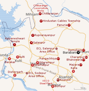 |
| Cities, towns and ECL Areas in the western portion of Asansol Sadar subdivision in Paschim Bardhaman district MC: municipal corporation, P: rural administrative centre, CT: census town, N: neighbourhood, OG: out growth, T: temple Owing to space constraints in the small map, the actual locations in a larger map may vary slightly |
Police station
Barabani police station has jurisdiction over Barabani CD Block. The area covered is 158.87 km2 and the population covered is 110,361.[1][2]
Urbanisation
As per the 2011 census, 83.33% of the population of Asansol Sadar subdivision was urban and 16.67% was rural.[3]In 2015, the municipal areas of Kulti, Raniganj and Jamuria were included within the jurisdiction of Asansol Municipal Corporation.[4]Asansol Sadar subdivision has 26 (+1 partly) Census Towns.(partly presented in the map alongside; all places marked on the map are linked in the full-screen map).
Demographics
As per 2011 Census of India Barabani had a total population of 2,330 of which 1,233 (53%) were males and 1,097 (47%) were females. Population below 6 years was 303. The total number of literates in Barabani was 1,204 (59.40% of the population over 6 years).[5]
Transport
Barabani is a station on the Andal-Jamuria-Sitarampur branch line.[6]
References
- ↑ "District Statistical Handbook 2014 Bardhaman". Tables 2.1, 2.2. Department of Statistics and Programme Implementation, Government of West Bengal. Retrieved 23 September 2018.
- ↑ "Asansol Durgapur Police Commissionerate". Find your police station. Asansol Durgapur Police. Archived from the original on 22 January 2012. Retrieved 18 February 2017.
- ↑ "District Statistical Handbook 2014 Burdwan". Table 2.2, 2.4(a). Department of Statistics and Programme Implementation, Government of West Bengal. Retrieved 4 September 2018.
- ↑ "The Kolkata Gazette" (PDF). Notification No. 335/MA/O/C-4/1M-36/2014 dated 3 June 2015. Department of Municipal Affairs, Government of West Bengal. Retrieved 4 September 2018.
- ↑ "2011 Census – Primary Census Abstract Data Tables". West Bengal – District-wise. Registrar General and Census Commissioner, India. Retrieved 18 February 2017.
- ↑ "73539 Andal-Jasidih DEMU". Time Table. indiarailinfo. Retrieved 18 February 2017.
Cities, towns and locations in Paschim Bardhaman district | |||||
|---|---|---|---|---|---|
| Cities, municipal and census towns | |||||
| Locations other than cities and towns |
| ||||
| Neighbourhoods in Asansol |
| ||||
| Related topics |
| ||||