Sirsha, India
| Sirsha | |
|---|---|
| Census Town | |
 Sirsha Location in West Bengal, India  Sirsha Sirsha (India) | |
| Coordinates: 23°41′06″N 87°18′06″E / 23.684932°N 87.301716°ECoordinates: 23°41′06″N 87°18′06″E / 23.684932°N 87.301716°E | |
| Country |
|
| State | West Bengal |
| District | Paschim Bardhaman |
| Government | |
| • Body | gram panchayat pradhan |
| Population (2011) | |
| • Total | 4,600 |
| Languages | |
| • Official | Bengali, English |
| Time zone | UTC+5:30 (IST) |
| Vehicle registration | WB |
| Lok Sabha constituency | Asansol |
| Vidhan Sabha constituency | Pandaveswar |
| Website |
bardhaman |
Sirsha is a census town in Faridpur Durgapur CD Block in Durgapur subdivision of Paschim Bardhaman district in the Indian state of West Bengal.
Geography
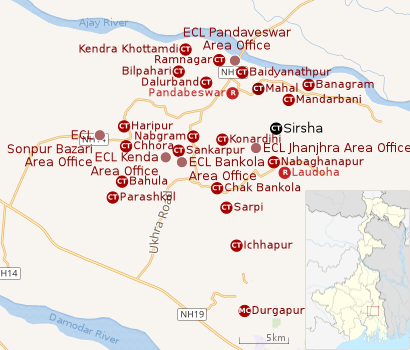 |
| Cities, towns and ECL Areas in the northern portion of Durgapur subdivision in Paschim Bardhaman district MC: Municipal Corporation, CT: census town, R: rural administrative centre Owing to space constraints in the small map, the actual locations in a larger map may vary slightly |
Location
Sirsha is located at 23°41′06″N 87°18′06″E / 23.684932°N 87.301716°E.
The Asansol-Durgapur region is composed of undulating laterite soil. This area lies between two mighty rivers – the Damodar and the Ajay. They flow almost parallel to each other in the region – the average distance between the two rivers is around 30 km. For ages the area was heavily forested and infested with plunderers and marauders. The discovery of coal in the 18th century led to industrialisation of the area and most of the forests have been cleared.[1]
Banagram, Mandarbani, Sirsha, Nabaghanapur, Sarpi and Ichhapur form a series of census towns along the western border of Faridpur-Durgapur CD Block.[2]
Urbanisation
As per the 2011 census, 79.22% of the population of Durgapur subdivision was urban and 20.78% was rural. Durgapur subdivision has 1 municipal corporation at Durgapur and 38 (+1 partly) census towns (partly presented in the map alongside; all places marked on the map are linked in the full-screen map).[3]
Demographics
As per the 2011 Census of India Sirsha had a total population of 4,600, of which 2,436 (53%) were males and 2,164 (47%) were females. Population below 6 years was 390. The total number of literates in Sirsha was 3,394 (80.62% of the population over 6 years).[4]
As of 2001 India census,[5] Sirsha had a population of 5,215. Males constitute 56% of the population and females 44%. Sirsha has an average literacy rate of 66%, higher than the national average of 59.5%: male literacy is 75%, and female literacy is 55%. In Sirsha, 12% of the population is under 6 years of age.
Education
Sirsha has one primary school.[6]
References
- ↑ Chattopadhyay, Akkori, Bardhaman Jelar Itihas O Lok Sanskriti (History and Folk lore of Bardhaman District.), (in Bengali), Vol I, pp 14-15, Radical Impression. ISBN 81-85459-36-3
- ↑ "District Census Handbook Bardhaman, Series 20, Part XII A, Census of India 2011" (PDF). Map of Faridpur Durgapur CD Block, page 257. Directorate of Census Operations, West Bengal. Retrieved 27 August 2018.
- ↑ "District Statistical Handbook 2014 Burdwan". Table 2.2, 2.4(a). Department of Statistics and Programme Implementation, Government of West Bengal. Retrieved 15 September 2018.
- ↑ "2011 Census – Primary Census Abstract Data Tables". West Bengal – District-wise. Registrar General and Census Commissioner, India. Retrieved 20 February 2017.
- ↑ "Census of India 2001: Data from the 2001 Census, including cities, villages and towns (Provisional)". Census Commission of India. Archived from the original on 2004-06-16. Retrieved 2008-11-01.
- ↑ 7th All-India School Education Survey 2003 Archived 2007-09-27 at the Wayback Machine.
Cities, towns and locations in Paschim Bardhaman district | |||||
|---|---|---|---|---|---|
| Cities, municipal and census towns | |||||
| Locations other than cities and towns |
| ||||
| Neighbourhoods in Asansol |
| ||||
| Related topics |
| ||||