Topsi
| Topsi | |
|---|---|
| Census Town | |
 Topsi Location in West Bengal, India  Topsi Topsi (India) | |
| Coordinates: 23°39′57″N 87°07′50″E / 23.665711°N 87.130422°ECoordinates: 23°39′57″N 87°07′50″E / 23.665711°N 87.130422°E | |
| Country |
|
| State | West Bengal |
| District | Paschim Bardhaman |
| Population (2011) | |
| • Total | 4,329 |
| Languages | |
| • Official | Bengali, English |
| Time zone | UTC+5:30 (IST) |
| PIN | 713362 (Toposi) |
| Telephone code | 91 341 |
| Lok Sabha constituency | Asansol |
| Vidhan Sabha constituency | Jamuria |
| Website |
bardhaman |
Topsi is a census town in Jamuria CD Block in Asansol Sadar subdivision of Paschim Bardhaman district in the Indian state of West Bengal.
Geography
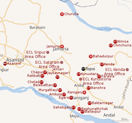 |
| Cities and towns in the eastern portion of Asansol Sadar subdivision in Paschim Bardhaman district MC: Municipal Corporation, CT: census town, N: neighbourhood, R: rural centre Owing to space constraints in the small map, the actual locations in a larger map may vary slightly |
Location
Topsi is located at 23°39′57″N 87°07′50″E / 23.665711°N 87.130422°E
Urbanisation
As per the 2011 census, 83.33% of the population of Asansol Sadar subdivision was urban and 16.67% was rural.[1]In 2015, the municipal areas of Kulti, Raniganj and Jamuria were included within the jurisdiction of Asansol Municipal Corporation.[2]Asansol Sadar subdivision has 26 (+1 partly) Census Towns.(partly presented in the map alongside; all places marked on the map are linked in the full-screen map).
Demographics
As per the 2011 Census of India, Topsi had a total population of 4,329 of which 2,249 (52%) were males and 2,080 (48%) were females. Population below 6 years was 556. The total number of literates in Topsi was 2,733 (72.44% of the population over 6 years).[3]
As per the 2011 census, the urban agglomeration (UA) centred upon Asansol had a population of 1,243,414. In addition to the erstwhile municipalities of Kulti, Jamuria, and Raniganj subsequently incorporated into the Asansol Municipal Corporation, the agglomeration included the census towns of Amkula, Baktarnagar, Ballavpur, Bhanowara, Domohani, Egara, Jemari (J.K. Nagar Township), Majiara, Murgathaul, Raghunathchak, Sahebganj and Topsi, and also Charanpur, an outgrowth of Jamuria.[4][2]
Economy
As per ECL website telephone numbers, operational collieries in the Kunustoria Area in 2018 are: Amritnagar Colliery, Amrasota Colliery, Bansra Colliery, Belbaid Colliery, Kunustoria Colliery, Mahabir OCP, North Searsole Colliery, Parasea Colliery, Parasea 6 & 7 Incline and Parasea OCP.[5]
Transport
Tapasi is a station on the Andal-Jamuria-Sitarampur branch line.[6]
References
- ↑ "District Statistical Handbook 2014 Burdwan". Table 2.2, 2.4(a). Department of Statistics and Programme Implementation, Government of West Bengal. Retrieved 4 September 2018.
- 1 2 "The Kolkata Gazette" (PDF). Notification No. 335/MA/O/C-4/1M-36/2014 dated 3 June 2015. Department of Municipal Affairs, Government of West Bengal. Retrieved 4 September 2018.
- ↑ "2011 Census – Primary Census Abstract Data Tables". West Bengal – District-wise. Registrar General and Census Commissioner, India. Retrieved 27 August 2018.
- ↑ "Constituents of Urban Agglomerations having population 1 lakh and above" (PDF). Provisional Population Total, Census of India 2011. Government of India. Retrieved 27 August 2018.
- ↑ "Area wise Closed User Group (CUG) Telephone Numbers" (PDF). Kunustoria Area. Eastern Coalfields Limited. Retrieved 18 August 2018.
- ↑ "73539 Andal-Jasidih DEMU". Time Table. indiarailinfo. Retrieved 18 August 2018.
Cities, towns and locations in Paschim Bardhaman district | |||||
|---|---|---|---|---|---|
| Cities, municipal and census towns | |||||
| Locations other than cities and towns |
| ||||
| Neighbourhoods in Asansol |
| ||||
| Related topics |
| ||||