Jhanjra
| Jhanjra | |
|---|---|
| Village | |
 Jhanjra Location in West Bengal, India  Jhanjra Jhanjra (India) | |
| Coordinates: 23°38′59.3″N 87°17′22.6″E / 23.649806°N 87.289611°ECoordinates: 23°38′59.3″N 87°17′22.6″E / 23.649806°N 87.289611°E | |
| Country |
|
| State | West Bengal |
| District | Paschim Bardhaman |
| • Rank | 2,125 |
| Languages | |
| • Official | Bengali, English |
| Time zone | UTC+5:30 (IST) |
| Telephone/STD code | 0343 |
| Lok Sabha constituency | Asansol |
| Vidhan Sabha constituency | Pandaveswar |
| Website |
bardhaman |
Jhanjra is a village in Faridpur Durgapur CD Block in Durgapur subdivision of Paschim Bardhaman district in the state of West Bengal, India.
Geography
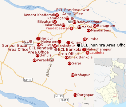 |
| Cities, towns and ECL Areas in the northern portion of Durgapur subdivision in Paschim Bardhaman district MC: Municipal Corporation, CT: census town, R: rural administrative centre Owing to space constraints in the small map, the actual locations in a larger map may vary slightly |
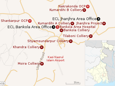 |
| Collieries in the Bankola and Jhanjhra Areas of Eastern Coalfields UG: Undergroud Colliery, OC: Open Cast Colliery, S: Mining support, A: Administrative headquarters Owing to space constraints in the small map, the actual locations in a larger map may vary slightly |
Location
The Jhanjra coal block is located on the north-eastern side of Raniganj Coalfield, 15 km north of NH 19 (old numbering NH 2)/ Grand Trunk Road and about the same distance by road from Durgapur.[1]
Urbanisation
As per the 2011 census, 79.22% of the population of Durgapur subdivision was urban and 20.78% was rural. Durgapur subdivision has 1 municipal corporation at Durgapur and 38 (+1 partly) census towns (partly presented in the map alongside; all places marked on the map are linked in the full-screen map).[2]
Demographics
As per the 2011 Census of India Jhanjra had a total population of 2,125, of which 1,098 (52%) were males and 1,027 (48%) were females. Population below 6 years was 219. The total number of literates in Jhanjra was 1,496 (78.49% of the population over 6 years).[3]
Economy
As per ECL website telephone numbers, operational collieries in the Jhanjra Area of Eastern Coalfields in 2018 are: Main Incline, I & II Incline, I & B Incline and 3 & 4 Incline.[4]
Jhanjra Project
The Jhanjra Area of Eastern Coalfields consists of only one colliery, the underground mechanised Jhanjra mine. The Jhanjra coal block covering a surface area of 11.50 km2, spread across 8 extractable seems, has a total reserve of about 200 miilion tonnes of coal. Development of this mine was initiated in the 1980s. While open-cast mining is cheaper and less labour-intensive, it is much less environment friendly compared to underground mining. Therefore, although India has depended on large scale open-cast mining to raise production of coal, the Jhanjra Project is an example of its new focus on underground mining.[1]
As of 2015-16, with the deployment of continuous miner mass production technology has been introduced in the Jhanjra mines. Longwall mining has also been introduced. Man riding system and free steered vehicle are already functional.[5]
See also - Pandaveswar Area#Mining plan - it includes Jhanjra
References
- 1 2 "Underground mining at Jhanjra allowed". Guru Mavin, 20 May 2015. Retrieved 18 August 2018.
- ↑ "District Statistical Handbook 2014 Burdwan". Table 2.2, 2.4(a). Department of Statistics and Programme Implementation, Government of West Bengal. Retrieved 15 September 2018.
- ↑ "2011 Census – Primary Census Abstract Data Tables". West Bengal – District-wise. Registrar General and Census Commissioner, India. Retrieved 20 February 2017.
- ↑ "Area wise Closed User Group (CUG) Telephone Numbers" (PDF). Kajora Area. Eastern Coalfields Limited. Retrieved 17 September 2018.
- ↑ "Planning". Eastern Coalfields Limited. Retrieved 22 February 2017.
Cities, towns and locations in Paschim Bardhaman district | |||||
|---|---|---|---|---|---|
| Cities, municipal and census towns | |||||
| Locations other than cities and towns |
| ||||
| Neighbourhoods in Asansol |
| ||||
| Related topics |
| ||||