Kiamba, Sarangani
| Kiamba | ||
|---|---|---|
| Municipality | ||
| Municipality of Kiamba | ||
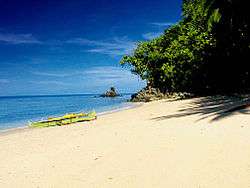 Tuka Beach | ||
| ||
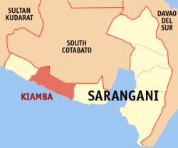 Map of Sarangani with Kiamba highlighted | ||
.svg.png) Kiamba Location within the Philippines | ||
| Coordinates: 5°59′N 124°37′E / 5.98°N 124.62°ECoordinates: 5°59′N 124°37′E / 5.98°N 124.62°E | ||
| Country |
| |
| Region | Soccsksargen (Region XII) | |
| Province | Sarangani | |
| District | Lone District | |
| Founded | 1947 | |
| Barangays | 19 (see Barangays) | |
| Government [1] | ||
| • Type | Sangguniang Bayan | |
| • Mayor | Raul C. Martinez | |
| • Electorate | 33,978 voters (2016) | |
| Area [2] | ||
| • Total | 328.68 km2 (126.90 sq mi) | |
| Population (2015 census)[3] | ||
| • Total | 61,058 | |
| • Density | 190/km2 (480/sq mi) | |
| Time zone | UTC+8 (PST) | |
| ZIP code | 9514 | |
| PSGC | 128003000 | |
| IDD : area code | +63 (0)83 | |
| Climate type | Tropical rainforest climate | |
| Income class | 1st municipal income class | |
| Revenue (₱) | 156,845,994.95 (2016) | |
| Native languages |
Cebuano Tboli Maguindanao language Blaan language Tagalog | |
| Website |
kiamba | |

Kiamba, officially the Municipality of Kiamba, is a 1st class municipality in the province of Sarangani, Philippines. According to the 2015 census, it has a population of 61,058 people.[3]
It is bordered on the west by Maitum, on the east by Maasim, on the north by South Cotabato, and on the south by the Celebes Sea.
Notable residents include Manny Pacquiao. It is the hometown of his wife Jinkee Pacquiao.[4][5][6]
History
The municipality was formed in August 18, 1947 when Executive Order No. 82 was signed by the government by merging the municipal districts of Kraan and Kling.
Maitum on the west became an independent municipality in 1959. In 1971, Maasim, on the east, also became an independent municipality. [7]
Barangays
Kiamba is politically subdivided into 19 barangays.
- Badtasan
- Datu Dani
- Gasi
- Kapate
- Katubao
- Kayupo
- Kling (Lumit)
- Lagundi
- Lebe
- Lomuyon
- Luma
- Maligang
- Nalus
- Poblacion
- Salakit
- Suli
- Tablao
- Tamadang
- Tambilil
Demographics
| Population census of Kiamba | ||
|---|---|---|
| Year | Pop. | ±% p.a. |
| 1990 | 35,418 | — |
| 1995 | 39,717 | +2.17% |
| 2000 | 44,724 | +2.58% |
| 2007 | 53,040 | +2.38% |
| 2010 | 54,871 | +1.24% |
| 2015 | 61,058 | +2.06% |
| Source: Philippine Statistics Authority[3][8][9][10] | ||
Majority of the population speak Cebuano although early settlers were of Ilocano origin. There are a lot of Moro people (Sangil and Maguindanaon) who settles in the area long before the Christians from Luzon came. One of the indigenous peoples living in mountainous areas of Kiamba is known as T'boli.
Economy
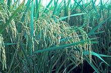
The economy of Kiamba is largely based on agriculture with vast ricefields surrounding the municipality. Aqua-culture is the second biggest income earner, notably the culture of milkfish and shrimps (locally called "sugpo" or "lukon") for export. Also, coastal communities depend on deep-sea fishing as a primary livelihood.
Tourism
The Timpuyog festival celebrates the town's foundation anniversary. Timpuyog is an Ilocano word for unity, and the festival includes tribal shows and carnaval. Kiamba celebrate their Timpuyog Festival and Foundation Anniversary every February 14.
Visitors attractions include:
- Waterfalls in lush rainforests (ex. Nalus Falls)
- Short, narrow roads lined with Japanese era houses
- Cockfights
- Tuka Marine Park, a protected area where fishing is banned. It has four protected coves and only one (Tuka 2) is open to the public. The site has coral formations.
- Beaches of Kiamba (ex. Wakap Beach in Datu Dani)
Notable educational institutions
- Kiamba National High School
- Notre Dame of Kiamba
- Southern Cotabato Academy
- J.B.T. Caing Sr. Memorial Integrated School
- James L. Chiongbian National Trade School (Formerly Kling National High school)
- Cabales-Enarbia Integrated School
- Salakit National High School
References
- ↑ "Municipality". Quezon City, Philippines: Department of the Interior and Local Government. Retrieved 31 May 2013.
- ↑ "Province: Sarangani". PSGC Interactive. Quezon City, Philippines: Philippine Statistics Authority. Retrieved 12 November 2016.
- 1 2 3 Census of Population (2015). "Region XII (Soccsksargen)". Total Population by Province, City, Municipality and Barangay. PSA. Retrieved 20 June 2016.
- ↑ http://balita.ph/2009/04/25/pacquiao-builds-house-in-sarangani/
- ↑ http://www.pia.gov.ph/?m=12&fi=p070220.htm&no=39
- ↑ http://sports.inquirer.net/breakingnews/breakingnews/view/20081216-178334/Pacquiao-to-run-for-House-seat
- ↑ "Kiamba Municipality was Born". Local Government of Kiamba. Retrieved 11 April 2017.
- ↑ Census of Population and Housing (2010). "Region XII (Soccsksargen)". Total Population by Province, City, Municipality and Barangay. NSO. Retrieved 29 June 2016.
- ↑ Censuses of Population (1903–2007). "Region XII (Soccsksargen)". Table 1. Population Enumerated in Various Censuses by Province/Highly Urbanized City: 1903 to 2007. NSO.
- ↑ "Province of Sarangani". Municipality Population Data. Local Water Utilities Administration Research Division. Retrieved 17 December 2016.
External links
- Kiamba Municipal Profile at the Province of Sarangani Official Website
- Kiamba - Official Website
- Philippine Standard Geographic Code
- Philippine Census Information
- Local Governance Performance Management System
- Tourism Article By Rene Venenzuela, Manila Bulletin
Places adjacent to Kiamba, Sarangani | |
|---|---|