Batu (city)
| Batu Kota Batu | ||
|---|---|---|
| City | ||
| City of Batu | ||
| Other transcription(s) | ||
| • Javanese | ꦏꦸꦛꦧꦠꦸ | |
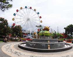 Alun-alun of Batu | ||
| ||
|
Motto(s): Javanese: ꦲꦏꦂꦪꦒꦸꦤꦩꦩꦪꦸꦧꦮꦤ English: Work to Advancing the World | ||
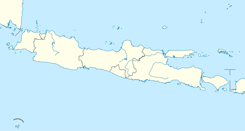
 Location within East Java | ||
| Coordinates: 7°52′19″S 112°31′30″E / 7.872°S 112.525°ECoordinates: 7°52′19″S 112°31′30″E / 7.872°S 112.525°E | ||
| Country |
| |
| Region | Java | |
| Province |
| |
| Government | ||
| • Mayor | Punjul Santoso | |
| • Vice Mayor | vacant[1] | |
| Area | ||
| • Total | 202.30 km2 (78.11 sq mi) | |
| Elevation | 953 m (3,127 ft) | |
| Population (2010) | ||
| • Total | 190,184[2] | |
| • Density | 873/km2 (2,260/sq mi) | |
| Time zone | UTC+7 (Indonesia Western Time) | |
| Area code | (+62) 341 | |
| Website |
batukota | |


Batu, officially the City of Batu (Indonesian: Kota Batu, Javanese: ꦏꦸꦛꦧꦠꦸ), is a city in the East Java Province of Indonesia. It is about 20 km to the northwest of Malang. Formerly, it was a part of Malang Regency; but in 2001, Batu became an independent city legalized by Act No. 11 of 2001, when it became an independent municipal city with its own mayor and council.[3]
With a population of 190,000 people, it lies on the southern slopes of Gunung Welirang. Its population largely consists of Javanese. The town used to be a recreation place for the Dutch colonial officers in the Dutch colonial area (before 1945). Batu means "rock" in Indonesian.
Geography
The city of Batu lies on a slope of several mountains. The most prominent are Mount Anjasmoro (2,277 m), Mount Arjuno (3,339 m), Mount Welirang (3,156 m), Mount Banyak (1,306 m), Mount Kawi (2,551 m), Mount Panderman (2,045 m), Mount Semeru (3.676 m), and Mount Wukir (335 m).
Batu is in a fertile mountainous area surrounded by agricultural land. In the 19th century, the Dutch East Indies government developed Batu as a mountain resort. Villas and resort facilities were built in Batu during the period.
Buta is a near-exact antipode (or polar opposites) to the city of San Fernando de Apure, Venezuela.
Administration
The city is divided into three districts (kecamatan): Batu, Bumiaji, and Junrejo. The districts are further subdivided into 24 villages (kelurahan).
The name of the villages are:
- Kecamatan Batu
- Ngaglik
- Oro - Oro Ombo RO
- Pesanggrahan
- Sidomulyo
- Sisir
- Songgokerto
- Sumberejo
- Temas
- Kecamatan Bumiaji
- Bulukerto
- Bumiaji
- Giripurno
- Gunungsari
- Pandanrejo
- Punten
- Sumberbrantas
- Sumbergondo
- Tulungrejo
- Kecamatan Junrejo
- Beji
- Dadaprejo
- Junrejo
- Mojorejo
- Pendem
- Tlekung
- Torongrejo
Tourism
Batu is well known for its tourism areas. Some of them are:
- Cuban Rondo Waterfall
- Jatim Park (Jawa Timur Park): a place for learning and playing.
- Jatim Park 2
- Selecta Pool and Garden
- BNS: Batu Night Spectacular
- Alun-Alun Batu
- Eco-Green Park
- Museum Angkut
- Pasar Parkiran
- Paralayang
- Coban Pitu
There is a historic colonial-style hotel, the Kartika Wijaya, which was founded in 1891 by the Sarkies Brothers, prominent Armenian immigrants best known for founding a chain of luxury hotels throughout Southeast Asia, especially Dutch East Indies. It was originally built as a vacation villa for the Sarkies family and was later turned into a hotel.
References
- ↑ "KPK Investigators Search Batu Police Station"
- ↑ http://jatim.bps.go.id
- ↑ Indonesia Humanity Foundation, Batu, Indonesia
External links
| Wikimedia Commons has media related to Batu (city). |
- Official website (in Indonesian)

- (in Indonesian)BPS