Soccsksargen
| SOCCSKSARGEN Region XII Central Mindanao (formerly) | |
|---|---|
| Region | |
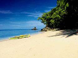 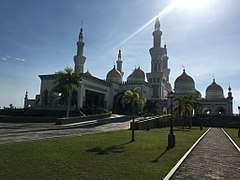 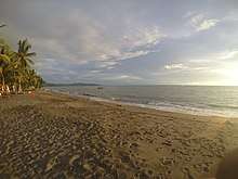    Tuka Beach in Kiamba, Sarangani; Sultan Haji Hassanal Bolkiah Masjid in Cotabato City; shoreline of Lebak, Sultan Kudarat; Asik-Asik Falls in Alamada, North Cotabato; skyline of General Santos City, the center for commerce, industry, and economy; and Koronadal City, South Cotabato, the political regional center | |
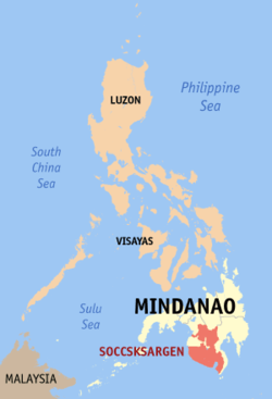 Location in the Philippines | |
| Coordinates: 6°30′N 124°51′E / 6.5°N 124.85°ECoordinates: 6°30′N 124°51′E / 6.5°N 124.85°E | |
| Country | Philippines |
| Island group | Mindanao |
| Regional center | Koronadal |
| Area | |
| • Total | 22,513.30 km2 (8,692.43 sq mi) |
| Population (2015 census)[1] | |
| • Total | 4,545,276 |
| • Density | 200/km2 (520/sq mi) |
| Time zone | UTC+8 (PST) |
| ISO 3166 code | PH-12 |
| Provinces | |
| Cities | |
| Municipalities | 45 |
| Barangays | 1,195 |
| Cong. districts | 6 |
| Languages | |
Soccsksargen (officially styled as SOCCSKSARGEN[2]) (pronounced [sokˈsardʒɛn]), formerly known simply as Cotabato or Kota Bato, is an administrative region of the Philippines, located in south-central Mindanao. It is numerically designated as Region XII. The name is an acronym that stands for the region's four provinces and 2 cities (South Cotabato, Cotabato City, Cotabato Province, Sultan Kudarat, Sarangani and General Santos City). The region used to be called Central Mindanao. The regional center is in Koronadal located in the province of South Cotabato, and the center of commerce and industry is General Santos City, which is the most populous city in the Region.
SOCCSKSARGEN encompasses Cotabato City situated within the borders of Maguindanao, a province of the Autonomous Region in Muslim Mindanao (ARMM).
Geography
The region is bounded on the north by Northern Mindanao, on the east by the Davao Region, and on the southwest by the Celebes Sea. The province of Maguindanao is situated between Cotabato City, North Cotabato province, and Sultan Kudarat.
The region has extensive coastlines, valleys and mountain ranges. Known for its river system, the region is the drainage basin of Mindanao, particularly at the Cotabato Basin, a large depression surrounded by mountain ranges on three sides.[3][4] Within the basin runs the Rio Grande de Mindanao, the longest river in Mindanao and the second longest in the Philippines. The river empties into the Illana Bay of the larger Moro Gulf at the west of Cotabato City.
At the south of the basin lie the Tiruray Highlands, a moderately high mountain range blocking the basin from the southern coastline.[3] Southeast of the mountains lie the Sarangani Bay.
History
The oldest civilization in the region is located in Maitum, Sarangani, where the Maitum Anthropomorphic Pottery were found. The jars have been declared as National Cultural Treasures, and are subject to the high protections ensured by Philippine and international laws.
The region used to be named Central Mindanao. Prior to the creation of the Autonomous Region in Muslim Mindanao (ARMM) it comprised the following provinces:
With the creation of ARMM, Lanao del Sur,and Maguindanao (excluding Cotabato City) were removed from the region, leaving Lanao del Norte, Cotabato and Sultan Kudarat, and Marawi and Cotabato City as constituent provinces and cities.[5] Lanao del Norte was later transferred to Northern Mindanao, while Marawi became part of the ARMM.
On September 2001, Executive Order No. 36 was signed by President Gloria Macapagal-Arroyo transferring South Cotabato, Sarangani, General Santos (also known as the SocSarGen District), and Koronadal from Southern Mindanao to Region XII, and renaming the region, from Central Mindanao, to SOCCSKSARGEN.[2][6]
Administrative divisions
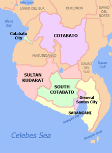
Soccsksargen comprises 4 provinces, 1 highly urbanized city, 1 independent component city, 3 component cities, 45 municipalities and 1,195 barangays.
| Province or City | Capital | Population (2015)[1] | Area[7][8] | Density | Cities | Muni. | Bgy. | |||||
|---|---|---|---|---|---|---|---|---|---|---|---|---|
| km2 | sq mi | /km2 | /sq mi | |||||||||
| Cotabato | Kidapawan | 30.4% | 1,379,747 | 9,008.90 | 3,478.36 | 150 | 390 | 1 | 17 | 543 | ||
| Sarangani | Alabel | 12.0% | 544,261 | 3,601.25 | 1,390.45 | 150 | 390 | 0 | 7 | 141 | ||
| South Cotabato | Koronadal | 20.1% | 915,289 | 3,935.95 | 1,519.68 | 230 | 600 | 1 | 10 | 199 | ||
| Sultan Kudarat | Isulan | 17.9% | 812,095 | 5,298.34 | 2,045.70 | 150 | 390 | 1 | 11 | 249 | ||
| Cotabato City | ‡ | — | 6.6% | 299,438 | 176.00 | 67.95 | 1,700 | 4,400 | — | — | 37 | |
| General Santos | † | — | 13.1% | 594,446 | 492.86 | 190.29 | 1,200 | 3,100 | — | — | 26 | |
| Total | 4,545,276 | 22,513.30 | 8,692.43 | 200 | 520 | 5 | 45 | 1,195 | ||||
| ||||||||||||
Cities
Component cities
Independent Component City
- Cotabato City — the regional center of the Autonomous Region in Muslim Mindanao, but the city is actually under the jurisdiction of the SOCCSKSARGEN region and does not belong to the ARMM
Highly-urbanized city
- General Santos — a highly urbanized city, it serves as the center of the Metropolitan and Regional Center for trade and industry of Soccsksargen.
| Rank | City | Area
in sq.km |
Population
as of 2015 |
Tax collection
as of 2012[9] |
IRA
as of 2015 |
Income class |
|---|---|---|---|---|---|---|
| 1. | General Santos | 492.86 | 594,446 | P1.175 billion | Php 1,086.25 million | 1st |
| 2. | Cotabato City | 176.00 | 299,438 | P1.168 billion
(including 1st district of Maguindanao) |
Php 580.18 million | 2nd |
| 3. | Koronadal | 277.00 | 174,942 | P917 million
(including South Cotabato) |
Php 504.77 million | 3rd |
| 4. | Kidapawan | 358.47 | 140,195 | P554 million
(including Cotabato Province) |
Php 509.68 million | 3rd |
| 5. | Tacurong | 153.40 | 98,316 | P555 million
(including Sultan Kudarat Province) |
Php 350.57 million | 4th |
Demographics
| Population census of SOCCSKSARGEN | ||
|---|---|---|
| Year | Pop. | ±% |
| 1990 | 2,399,953 | — |
| 2000 | 3,222,169 | +34.3% |
| 2010 | 4,109,571 | +27.5% |
| 2015 | 4,545,276 | +10.6% |
| Source: Philippine Statistics Authority[1] | ||
Government
Provincial Governors
HUC/ICC MAYORS
Economy
The region contributes to the national GDP with 2.6% with 5% growth compared to 2016. 18.3% of Mindanao Gross Regional Domestic Product (GRDP).[10]
Musical heritage
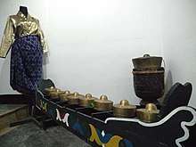
The culture of native Maguindanaon and other native groups, both Muslim and non-Muslim, revolves around kulintang music, a specific type of gong music, found in the SoCCSKSarGen.
References
- 1 2 3 Census of Population (2015). Highlights of the Philippine Population 2015 Census of Population. PSA. Retrieved 20 June 2016.
- 1 2 "Executive Order No. 36; Providing for the Reorganization of the Administrative Regions in Mindanao and for Other Purposes". Official Gazette of the Republic of the Philippines. Malacañang, Manila, Philippines. 19 September 2001. Retrieved 29 March 2016.
SECTION 4. Region XII is hereby reorganized to be known as SOCCSKSARGEN and shall be composed of the following provinces and cities: a. Provinces i. North Cotabato ii. Sarangani iii. South Cotabato iv. Sultan Kudarat b. Cities i. Cotabato City ii. General Santos City iii. Kidapawan City iv. Koronadal City v. Tacurong City
- 1 2 Wernstedt, Frederick L.; Spencer, Joseph Earl (1978). The Philippine Island World: A Physical, Cultural, and Regional Geography. Berkeley: University of California Press. pp. 32–37. ISBN 9780520035133. Retrieved 27 January 2016.
- ↑ Hinz, Erhard (1985). Human Helminthiases in the Philippines the Epidemiological and Geomedical Situation. Berlin, Heidelberg: Springer Berlin Heidelberg. pp. 129–131. ISBN 9783642708411. Retrieved 27 January 2016.
- ↑ "2000 Census of Population and Housing; Central Mindanao: Literacy Rate at 87 Percent". Philippine Statistics Authority. 9 December 2002. Retrieved 29 March 2016.
As of May 1, 2000, the total population of Central Mindanao which covers the provinces of Lanao del Norte, North Cotabato, and Sultan Kudarat; and the cities of Iligan, Marawi and Cotabato, was 2,598,210 persons.
- ↑ "Southern Mindanao Is Now All Davao Region". RDC XI Bulletin (Oct-Dec 2001, Volume 7). National Statistical Coordination Board. 29 January 2002. Archived from the original on 2 January 2016. Retrieved 29 March 2016.
Southern Mindanao or Region XI is now known as Davao Region and comprises four provinces (Compostela Valley, Davao del Norte, Davao del Sur and Davao Oriental) and five cities (Davao, Digos, Panabo, Tagum and the Island Garden City of Samal. Said provinces and cities are situated along the Davao Gulf area. South Cotabato, Sarangani, General Santos City (SOCSARGEN) and Koronadal City, which were part of the old Region XI) have been transferred to Region XII.
- ↑ "List of Provinces". PSGC Interactive. Makati City, Philippines: National Statistical Coordination Board. Retrieved 20 March 2013.
- ↑ "List of Cities". PSGC Interactive. Makati City, Philippines: National Statistical Coordination Board. Retrieved 20 March 2013.
- ↑ Zonio, Aquiles Z. "Central Mindanao PH's top tax revenue generator next to Metro Manila". business.inquirer.net. Retrieved 2017-05-18.
- ↑ NEDA launches regional dev’t plan in SOCCSKSARGEN.
External links

- National Statistical Coordination Board: REGION XII (SOCCSKSARGEN)
Places adjacent to Soccsksargen | |
|---|---|

