Lake Sebu, South Cotabato
| Lake Sebu | ||
|---|---|---|
| Municipality | ||
| Municipality of Lake Sebu | ||
 The eponymous Lake Sebu | ||
| ||
|
Nickname(s): Home of the T'nalak Weavers(ing) Philippines' Natural Wonder Summer Capital of Southern Mindanao Bowl of Forest and Mountains | ||
 Map of South Cotabato with Lake Sebu highlighted | ||
.svg.png) Lake Sebu Location within the Philippines | ||
| Coordinates: 6°13′N 124°42′E / 6.22°N 124.7°ECoordinates: 6°13′N 124°42′E / 6.22°N 124.7°E | ||
| Country |
| |
| Region | Soccsksargen (Region XII) | |
| Province | South Cotabato | |
| District | 2nd District | |
| Barangays | 19 (see Barangays) | |
| Government [1] | ||
| • Type | Sangguniang Bayan | |
| • Mayor | Antonio Fungan | |
| • Electorate | 33,269 voters (2016) | |
| Area [2] | ||
| • Total | 702.00 km2 (271.04 sq mi) | |
| Population (2015 census)[3] | ||
| • Total | 87,442 | |
| • Density | 120/km2 (320/sq mi) | |
| Time zone | UTC+8 (PST) | |
| ZIP code | 9506 | |
| PSGC | 126319000 | |
| IDD : area code | +63 (0)83 | |
| Climate type | Tropical rainforest climate | |
| Income class | 1st municipal income class | |
| Revenue (₱) | 224,578,056.21 (2016) | |
| Native languages |
Tboli Hiligaynon Cebuano Blaan language Tagalog | |
| Website |
lakesebuscot | |

Lake Sebu, officially the Municipality of Lake Sebu, is a 1st class municipality in the province of South Cotabato, Philippines. According to the 2015 census, it has a population of 87,442 people.[3]
The bestselling Lonely Planet described Lake Sebu as a place located in a “bowl of forests and mountains.” The 42,450-hectare landscape consisting the domains of the Allah Valley is recognized by United Nations Educational, Scientific and Cultural Organization (UNESCO) as a cultural landscape in Mindanao.[4]
Geography
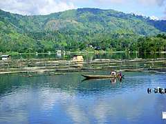
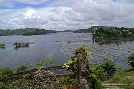
The placid lake of Lake Sebu can be found in Allah Valley near the municipality of Surallah, South Cotabato. Surrounded by rolling hills and mountains covered with thick rain forest, the lake has an area of 354 hectares (870 acres), with an elevation of approximately 1,000 metres (3,300 ft).
Barangays
Lake Sebu is politically subdivided into 19 barangays.
- Bacdulong
- Denlag
- Halilan
- Hanoon
- Klubi
- Lake Lahit
- Lamcade
- Lamdalag
- Lamfugon
- Lamlahak
- Lower Maculan
- Luhib
- Ned
- Poblacion
- Lake Seloton
- Talisay
- Takunel
- Upper Maculan
- Tasiman
≤SML?≥→
Demographics
| Population census of Lake Sebu | ||
|---|---|---|
| Year | Pop. | ±% p.a. |
| 1990 | 34,350 | — |
| 1995 | 47,617 | +6.31% |
| 2000 | 54,142 | +2.79% |
| 2007 | 60,401 | +1.52% |
| 2010 | 76,170 | +8.81% |
| 2015 | 87,442 | +2.66% |
| Source: Philippine Statistics Authority[3][5][6][7] | ||
The lake's shores and the surrounding rainforest are home to the indigenous T'bolis, Tirurays, Ubos and Manobos. One of the major tribes, the T'bolis are known for their weaving skills and brassware production as well as fishing skills. The rest of the population are made of Ilonggos, Bicolanos and Ilocanos.
Economy
The economy is based on aquaculture of Tilapia grown in large fish cages floating in the lake. More than one half of the land around the lake is cultivated for agriculture. The Philippine government is also trying to promote ecotourism in the area. The finishing of a concrete road cut the travel time from 4 hours to less than 30 minutes greatly improving trade and commerce.
Wildlife
Wild boars and Philippine Deer which are considered endangered live around the lake. The lake and the surrounding rainforest are natural habitat to egrets, kingfishers, swallows, herons, Philippine cockatoos and kites.
Environmental conservation
The Philippine government proclaimed a 924.5 square kilometres (357.0 sq mi) area as a protected landscape. On the south-eastern watershed of the lake, a bamboo plantation was established.
References
- ↑ "Municipality". Quezon City, Philippines: Department of the Interior and Local Government. Retrieved 31 May 2013.
- ↑ "Province: South Cotabato". PSGC Interactive. Quezon City, Philippines: Philippine Statistics Authority. Retrieved 12 November 2016.
- 1 2 3 Census of Population (2015). "Region XII (Soccsksargen)". Total Population by Province, City, Municipality and Barangay. PSA. Retrieved 20 June 2016.
- ↑ https://www.rappler.com/life-and-style/travel/ph-travel/89575-beautiful-beaches-waterfalls-lakes-mindanao
- ↑ Census of Population and Housing (2010). "Region XII (Soccsksargen)". Total Population by Province, City, Municipality and Barangay. NSO. Retrieved 29 June 2016.
- ↑ Censuses of Population (1903–2007). "Region XII (Soccsksargen)". Table 1. Population Enumerated in Various Censuses by Province/Highly Urbanized City: 1903 to 2007. NSO.
- ↑ "Province of South Cotabato". Municipality Population Data. Local Water Utilities Administration Research Division. Retrieved 17 December 2016.
External links
| Wikimedia Commons has media related to Lake Sebu, South Cotabato. |
Places adjacent to Lake Sebu, South Cotabato | |
|---|---|
Koronadal (capital) | |
| Municipalities | |
| Component City | |
| Highly Urbanized City |
|