Banisilan, Cotabato
| Banisilan | ||
|---|---|---|
| Municipality | ||
| Municipality of Banisilan | ||
| ||
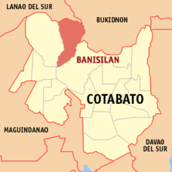 Map of Cotabato with Banisilan highlighted | ||
.svg.png) Banisilan Location within the Philippines | ||
| Coordinates: 7°30′N 124°42′E / 7.5°N 124.7°ECoordinates: 7°30′N 124°42′E / 7.5°N 124.7°E | ||
| Country |
| |
| Region | Soccsksargen (Region XII) | |
| Province | Cotabato | |
| District | 3rd District | |
| Founded | February 8, 1982 | |
| Barangays | 20 (see Barangays) | |
| Government [1] | ||
| • Type | Sangguniang Bayan | |
| • Mayor | Jesus F. Alisasis | |
| • Vice Mayor | John Raymund P. Allado | |
| • Electorate | 23,288 voters (2016) | |
| Area [2] | ||
| • Total | 577.22 km2 (222.87 sq mi) | |
| Population (2015 census)[3] | ||
| • Total | 43,677 | |
| • Density | 76/km2 (200/sq mi) | |
| Time zone | UTC+8 (PST) | |
| ZIP code | 9416 | |
| PSGC | 124716000 | |
| IDD : area code | +63 (0)64 | |
| Climate type | Tropical rainforest climate | |
| Income class | 2nd municipal income class | |
| Revenue (₱) | 151,858,075.56 (2016) | |
| Native languages |
Hiligaynon Cebuano Western Bukidnon language Iranun Tagalog | |
| Website |
www | |

Banisilan, officially the Municipality of Banisilan, is a 2nd class municipality in the province of Cotabato, Philippines. According to the 2015 census, it has a population of 43,677 people.[3]
Geography
Located at the northern quadrant of Cotabato Province bounded on the north by the municipality of Wao, Lanao del Sur, on the east to north-east by the municipality of Carmen and Bukidnon, on the west by Alamada, on the south by the municipality of Pikit.
Barangays
Banisilan is politically subdivided into 20 barangays. [2]
- Busaon
- Capayangan
- Carugmanan
- Gastav
- Kalawaig
- Kiaring
- Malagap
- Malinao
- Miguel Macasarte
- Pantar
- Paradise
- Pinamulaan
- Poblacion I
- Poblacion II
- Puting-bato
- Salama
- Thailand
- Tinimbacan
- Tumbao-Camalig
- Wadya
Climate
Banisilan has wet and dry seasons, a general characteristic of the Philippian climate.[4]
History
Banisilan accidentally acquired its name from a type of fresh water shell called the Banisil[5] which were then abundant in the area.
Before Banisilan was created as a separate municipality from Carmen, its mother town, President Ramon Magsaysay signed Proclamation No. 317 dated July 17, 1956 reserving an area of 100,018 hectares of land for a resettlement project which was under the general administration (NARRA) now known as the Department of Agrarian Reform. This resettlement project covers three (3) municipalities and part of these is the North Cotabato Resettlement Project No. 1. As years passed, hundreds of landless and qualified citizens coming from almost all parts of the country were resettled in the area. On March 19, 1959 the first batch of settlers from Panay called SAKADA, headed by Jesus T. Alisasis who become the first Vice Mayor, set foot in Banisilan and in the succeeding months, other tribes from Luzon followed.
Possible isolation due to future establishment of Bangsamoro
During the 2001 Referendum for inclusion to the Autonomous Region in Muslin Mindanao, two (2) out of twenty-eight (28) barangays of Carmen, Cotabato chose to be part of ARMM, but were excluded because they are not connected to the main region of ARMM. During 2010-2016 Administration, the Bangsamoro ideal sprouted and a newly proposed region was in the making. According to the agreements signed by the Moro Islamic Liberation Front and the Administration of Noynoy Aquino, Carmen will be included in Bangsamoro because of the two out of twenty-eight barangays that voted in favor of joining the Muslim region back in 2001. Unfortunately, Bangsamoro was not implemented before the term of Aquino ended. Despite this, the current administration aims to establish a Federal Government, where Bangamoro will be realized into a State of the Philippines wherein Carmen will be included in Bangsamoro.
Plans to establish a new municipality in the south of Carmen so that the indigenous and Christian central and northern part of Carmen will be retained in North Cotabato has yet to be confirmed. The idea arose because once the entire municipality of Carmen is included in Bangsamoro, the province of North Cotabato will be cut into half, leaving three towns (Banisilan, Alamada, and Libungan) at its west without connection to the center of North Cotabato, isolating these towns in the process.
Demographics
| Population census of Banisilan | ||
|---|---|---|
| Year | Pop. | ±% p.a. |
| 1990 | 36,213 | — |
| 1995 | 29,352 | −3.86% |
| 2000 | 35,539 | +4.19% |
| 2007 | 36,567 | +0.39% |
| 2010 | 39,914 | +3.24% |
| 2015 | 43,677 | +1.73% |
| Source: Philippine Statistics Authority[3] [6] [7] [8] | ||
In the 2015 census, the population of Banisilan, Cotabato, was 43,677 people,[3] with a density of 76 inhabitants per square kilometre or 200 inhabitants per square mile.
Natural resources
A large agricultural area is devoted to agri-production, producing resources like corn, palay, rubber, sugar cane and fruit trees.
Tourist attractions
- Mount Opao - This mountain is located between the boundaries of Banisilan and Alamada. It has natural grown trees and a cold spring.
References
- ↑ "Municipality". Quezon City, Philippines: Department of the Interior and Local Government. Retrieved 31 May 2013.
- 1 2 "Province: North Cotabato". PSGC Interactive. Quezon City, Philippines: Philippine Statistics Authority. Retrieved 12 November 2016.
- 1 2 3 4 Census of Population (2015). "Region XII (Soccsksargen)". Total Population by Province, City, Municipality and Barangay. PSA. Retrieved 20 June 2016.
- ↑ http://www.philippines.hvu.nl/climate1.htm
- ↑ http://www.cotabatoprov.gov.ph/lgus/banisilan
- ↑ Census of Population and Housing (2010). "Region XII (Soccsksargen)". Total Population by Province, City, Municipality and Barangay. NSO. Retrieved 29 June 2016.
- ↑ Censuses of Population (1903–2007). "Region XII (Soccsksargen)". Table 1. Population Enumerated in Various Censuses by Province/Highly Urbanized City: 1903 to 2007. NSO.
- ↑ "Province of North Cotabato". Municipality Population Data. Local Water Utilities Administration Research Division. Retrieved 17 December 2016.
External links
Places adjacent to Banisilan, Cotabato | |
|---|---|