Windham, New Hampshire
Windham is a suburban town in Rockingham County, New Hampshire, United States. The population was 13,592 at the 2010 census.[2] The estimated population in 2018 was 14,747.[3]
Windham, New Hampshire | |
|---|---|
Town | |
 Seal | |
| Motto(s): Old Values, New Horizons | |
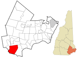 Location in Rockingham County and the state of New Hampshire. | |
| Coordinates: 42°48′02″N 71°18′15″W | |
| Country | United States |
| State | New Hampshire |
| County | Rockingham |
| Incorporated | 1742 |
| Villages | Windham West Windham Windham Depot |
| Government | |
| • Board of Selectmen | Ross McLeod, Chair Heath Partington Roger Hohenberger Joel Desilets Bruce Breton[1] |
| • Town Administrator | David Sullivan |
| Area | |
| • Total | 27.9 sq mi (72.2 km2) |
| • Land | 26.8 sq mi (69.4 km2) |
| • Water | 1.1 sq mi (2.7 km2) 3.80% |
| Elevation | 194 ft (59 m) |
| Population (2010) | |
| • Total | 13,592 |
| • Density | 490/sq mi (190/km2) |
| Time zone | UTC-5 (Eastern) |
| • Summer (DST) | UTC-4 (Eastern) |
| ZIP code | 03087 |
| Area code(s) | 603 |
| FIPS code | 33-85780 |
| GNIS feature ID | 0873758 |
| Website | www |
History
The area was initially home to the Pawtucket Native Americans. Scottish immigrants began to settle in the area in 1719. The region was known as “Nutfield” and included what are now the neighboring towns of Derry and Londonderry.[4] By 1721 some of the original settlers petitioned to form a separate independent community. Governor Benning Wentworth granted this request in 1742.[4] One published theory holds that the community's name refers to Windham, Ireland, harkening back to the petitioners' homeland. However, it has been alternatively postulated that the town was named after Sir Charles Wyndham, 2nd Earl of Egremont, a member of Parliament from 1734 to 1750, Secretary of State for the Southern Department from 1761 to 1763, and a good friend of Governor Wentworth.[4] The town of Windham was originally a parish of Londonderry. Windham was the second town designated by Governor Benning Wentworth following the establishment of the New Hampshire-Massachusetts border. Windham was the birthplace of Samuel Dinsmoor, Governor of New Hampshire from 1831 to 1834. The first census ever taken in Windham totaled at 663 residents in the year 1790.[5]
Historic landmarks in Windham include the Searles School, Searles Castle, the town center, and the Armstrong Memorial Building.[4] Searles Castle is one of Windham's most prominent landmarks. Edward F. Searles, an interior decorator and antique collector, built the castle.[6] The architect, Henry Vaughn, modeled the castle's architecture after the style of the Stanton Harcourt Manor in Oxfordshire, England.[6] The building was completed in 1915 at a cost of over $1,250,000. The castle contains over 20 rooms and is available to the public to be rented out for functions and events.[6] In July 1909, Mr. Searles erected a commemorative plaque honoring governor Samuel Dinsmoor "a few rods" from his birthplace on Jenny's Hill,[7] which stands today as a designated historic landmark.[4][8]
Geography
Windham is situated in Rockingham County in southeastern New Hampshire, approximately 3 miles (5 km) north of the Massachusetts border. It is accessible from Exit 3 of Interstate 93.[9] Windham is considered a bedroom community because of its growing population (over 10,000), only about 160 commercial land parcels, and lack of public transportation.[9] The nearest airport to Windham is Manchester-Boston Regional Airport, about 20 miles (32 km) to the north. Boston, Massachusetts, is 37 miles (60 km) to the south along Interstate 93.[9] The landscape of Windham consists of suburban subdivisions, rural open spaces and large areas of undeveloped land.[10]
According to the United States Census Bureau, the town has a total area of 27.9 square miles (72 km2), of which 26.8 sq mi (69 km2) is land and 1.1 sq mi (2.8 km2) is water, comprising 3.80% of the town. The highest point is Jenny's Hill, at 505 feet (154 m) above sea level.
Adjacent municipalities
- Derry, New Hampshire (north)
- Salem, New Hampshire (east)
- Pelham, New Hampshire (south)
- Hudson, New Hampshire (southwest)
- Londonderry, New Hampshire (northwest)
Demographics
| Historical population | |||
|---|---|---|---|
| Census | Pop. | %± | |
| 1790 | 663 | — | |
| 1800 | 751 | 13.3% | |
| 1810 | 742 | −1.2% | |
| 1820 | 889 | 19.8% | |
| 1830 | 1,006 | 13.2% | |
| 1840 | 926 | −8.0% | |
| 1850 | 818 | −11.7% | |
| 1860 | 846 | 3.4% | |
| 1870 | 753 | −11.0% | |
| 1880 | 695 | −7.7% | |
| 1890 | 632 | −9.1% | |
| 1900 | 641 | 1.4% | |
| 1910 | 656 | 2.3% | |
| 1920 | 543 | −17.2% | |
| 1930 | 538 | −0.9% | |
| 1940 | 630 | 17.1% | |
| 1950 | 964 | 53.0% | |
| 1960 | 1,317 | 36.6% | |
| 1970 | 3,008 | 128.4% | |
| 1980 | 5,664 | 88.3% | |
| 1990 | 9,000 | 58.9% | |
| 2000 | 10,709 | 19.0% | |
| 2010 | 13,592 | 26.9% | |
| Est. 2017 | 14,562 | [11] | 7.1% |
| U.S. Decennial Census[12] | |||
As of the census of 2010, there were 13,592 people, 4,724 households, and 3,773 families residing in the town. The population density was 507.2 people per square mile of land (195.9/km²). There were 5,164 housing units at an average density of 192.7 per square mile (74.4/km²). The racial makeup of the town was 95.2% White, 0.4% African American, 0.2% Native American, 2.9% Asian, 0.1% Pacific Islander, 0.2% some other race, and 1.1% from two or more races. Hispanic or Latino of any race were 1.6% of the population.
There were 4,724 households, out of which 35.3% had children under the age of 18 living with them, 71.6% were headed by a married couple living together, 6.0% had a female householder with no husband present, and 20.1% were non-families. 15.7% of all households were made up of individuals, and 7.2% were someone living alone who was 65 years of age or older. The average household size was 2.87, and the average family size was 3.25.
In the town, the population was spread out with 27.9% under the age of 18, 5.5% from 18 to 24, 22.1% from 25 to 44, 33.1% from 45 to 64, and 11.5% who were 65 years of age or older. The median age was 41.8 years. For every 100 females, there were 97.2 males. For every 100 females age 18 and over, there were 94.0 males.[2]
For the period 2006-2010, the median income for a household in the town was $112,386 (in 2010 dollars) and the median income for a family was $121,452. Male full-time year-round workers had a median income of $93,588 versus $55,445 for females. The per capita income for the town was $46,071. About 0% of families and 0.6% of the population were below the poverty line, including 0% of those under age 18 and 3.6% of those age 65 or over.[13]
Transportation
Four New Hampshire state routes and one Interstate highway cross Windham.
- NH 28 follows the longer Rockingham Road along the eastern edge of town, connecting Windham to Salem in the south and Derry in the north.
- NH 111 is the main east–west route across Windham, following Haverhill Road west of the town center, Indian Rock Road east of the town center, and Range Road after intersecting with 111-A.
- NH 111-A runs from south-central Windham, where it enters the town from Pelham, to a terminus with Route 111 at the eastern edge of town. The route passes between Cobbett's Pond and Canobie Lake along Range Road.
- NH 128 passes briefly across the western edge of town, running north–south near the border with Hudson. It forms part of the larger Mammoth Road.
- Interstate 93 crosses the town from southeast to northwest. There is one interchange in Windham, Exit 3, which provides access to NH 111.
The nearest airport is Manchester–Boston Regional Airport along the border of Londonderry and Manchester. The nearest rail service is the Lowell Line of the MBTA Commuter Rail which can be accessed at the Charles A. Gallagher Transit Terminal in Lowell, Massachusetts. The nearest Amtrak stations are Boston's North Station or South Station.
Education
The Windham School District currently serves over 3,000 students at the four public schools.[14] Pre-kindergarten through fourth-grade students attend Golden Brook School. In 2019, the Golden Brook School welcomed its first all-day kindergarten class for the first year. Fifth through sixth-grade students attend Windham Center School. Windham Middle School, home of the Wildcats, is occupied by seventh and eighth-graders. Windham High School, home to the Jaguars, consists of grades nine through twelve and opened in the fall of 2009. The class of 2012 was the first graduating class at Windham High School.[15][14] Prior to opening its own high school, students from Windham went to the high school in neighboring Salem, beginning in 1995. The class of 2011 was the last Windham/Salem graduating class from Salem High School. Earlier, in the 1990s and late 1980s, students attended Pinkerton Academy in Derry.
Windham is part of the School Administrative Unit 95, consisting only of the Windham School District.[16]
Recreation and town services
Windham includes a variety of local attractions such as municipal parks, golf courses, tennis courts, bowling facilities, youth recreation programs, fishing, hunting, boating, snowmobile transits, bike trails, and waterfront access. The Windham Country Club golf course is an 18-hole premier course voted four stars by Golf Digest. Men's leagues, women's leagues, and youth leagues are offered at the course.[17] Griffin Park, built in 2005, offers three baseball fields, a soccer field, tennis and basketball courts, and a playground. Windham's town beach is located on Cobbetts Pond. Lifeguards are on duty from mid-June to Labor Day. Swimming lessons are available every summer. An open boat launch is available to Windham residents next to the town beach. The Windham Rail Trail, which extends from Windham into Derry, is 4.1 miles (6.6 km) of level, paved trail for walking/biking. [upper-alpha 1] Windham's Recreation Athletic youth programs include football and cheerleading, baseball, tennis, lacrosse, basketball, and soccer.[19]
The Nesmith Library is Windham's public library. Each June Friends of the Library of Windham (FLOW) host Windham's annual Strawberry Festival. The festival hosts local food businesses around Windham such as The Village Bean. Residents of Windham take part in the annual three to five-mile walk known as the Turkey Trot. It takes place every year on Thanksgiving morning through the neighborhoods of Windham and raises money for the local Shepherd's Food Pantry.[20] The Strawberry Festival was moved to Windham High School in 2009 due to the overcrowding at the library in previous years.
The Windham Fire Department is a full-time, 24-hour department. In addition to providing emergency services, the department also works closely with community organizations on fire prevention units in the school district, and CPR and first aid classes. The Windham Police Department is a full-time department staffed by seventeen personnel, including the chief, captain, four sergeants, two detectives, and eight patrol officers. Internal assignments include a Traffic and Community Resource Officer. Resource officers are placed at the Middle School and High School. The department also has on staff a full-time prosecutor, a part-time records clerk and full-time department secretary. Both the fire and police department are located in the center of Windham across from the Windham Town Hall. The nearest hospital is Parkland Medical Center, 5 miles (8.0 km) away in Derry.
Notable people
- Samuel Dinsmoor, fourteenth Governor of New Hampshire[21]
- Sully Erna, vocalist of rock band Godsmack[22]
- Corey Lewandowski, political operative[23]
Coronavirus (COVID-19)
As of Friday, March 13, there has been one confirmed case of Covid-19. This was confirmed by the town government on their website.
References
Notes
- However, with the I-93 transit study came a suggestion to revitalize the line that ran through Windham for commuter and freight rail. Since there is not enough space for both rail and trail, the trail would have to be discontinued.[18]
Citations
- "Board of Selectmen". Town of Windham. Retrieved July 10, 2019.
- "Profile of General Population and Housing Characteristics: 2010 Demographic Profile Data (DP-1) - Windham town, Rockingham County, New Hampshire". U.S. Census Bureau. Archived from the original on February 12, 2020. Retrieved November 27, 2012.
- "Annual Estimates of the Resident Population: April 1, 2010 to July 1, 2018 (PEPANNRES): New Hampshire Minor Civil Divisions". American Factfinder. U.S. Census Bureau. Archived from the original on February 13, 2020. Retrieved January 7, 2020.
- "The Birth of Windham". The Birth of Windham. Archived from the original on February 4, 2012. Retrieved November 4, 2011.
- "Windham Government". Windham Government. Archived from the original on June 9, 2011. Retrieved November 10, 2011.
- "Searles Castle at Windham". Searles Castle at Windham. Retrieved November 4, 2011.
- Bradford R. Dinsmore (2003). Windham. Arcadia Publishing. ISBN 978-0-7385-1320-1.
- https://www.panoramio.com/photo/74538187
- "Welcome to Windham, NH Demographics". Welcome to Windham, NH Demographics. Archived from the original on February 5, 2012. Retrieved November 4, 2011.
- "Welcome to the town of Windham, NH". Welcome to the Town of Windham, NH. Retrieved November 4, 2011.
- "Annual Estimates of the Resident Population: April 1, 2010 to July 1, 2017 (PEPANNRES): Minor Civil Divisions – New Hampshire". Archived from the original on February 13, 2020. Retrieved November 15, 2018.
- "Census of Population and Housing". Census.gov. Retrieved June 4, 2016.
- "Selected Economic Characteristics: 2006-2010 American Community Survey 5-Year Estimates (DP03) - Windham town, Rockingham County, New Hampshire". U.S. Census Bureau. Archived from the original on February 12, 2020. Retrieved November 27, 2012.
- "Welcome to the Windham School District". Windham School District. Archived from the original on November 12, 2011. Retrieved November 10, 2011.
- "New Windham High has its first senior class". Eagle Tribune. September 7, 2011. Retrieved November 29, 2012.
- "SAU Schools | NH Department of Education". my.doe.nh.gov. Retrieved January 7, 2020.
- "Windham Country Club". Windham Country Club. Archived from the original on August 17, 2011. Retrieved November 10, 2011.
- HNTB Corporation; Parsons Brinckerhoff Quade & Douglas, Inc.; Fitzgerald & Halliday, Inc.; KKO & Associates. "I-93 Corridor Multi-Modal Transit Investment Study" (PDF). New Hampshire Department of Transportation. p. 7. Retrieved December 2, 2015.
- "Windham Recreational Department". Windham Recreational Department. Archived from the original on February 4, 2012. Retrieved November 10, 2011.
- "Welcome to the Town of Windham". Welcome to the Town of Windham. Retrieved November 10, 2011.
- "DINSMOOR, Samuel, (1766 - 1835)". Biographical Directory of the United States Congress. Retrieved January 11, 2014.
- Godsmack singer involved in I-93 crash » Merrimack Valley » EagleTribune.com, North Andover, MA
- Eder, Steve; Bidgood, Jess (April 14, 2016). "Before Trump Campaign, Corey Lewandowski Rode Herd on a Town's Leaders". The New York Times. Retrieved January 6, 2017.
External links
Places adjacent to Windham, New Hampshire | ||||||||||
|---|---|---|---|---|---|---|---|---|---|---|
| ||||||||||
Municipalities and communities of Rockingham County, New Hampshire, United States | ||
|---|---|---|
| City |  Map of New Hampshire highlighting Rockingham County | |
| Towns |
| |
| CDPs | ||
| Other villages | ||
| Authority control |
|
|---|