North Hampton, New Hampshire
North Hampton is a town in Rockingham County, New Hampshire, United States. The population was 4,301 at the 2010 census.[1] While the majority of the town is inland, North Hampton includes a part of New Hampshire's limited Atlantic seacoast.
North Hampton, New Hampshire | |
|---|---|
 1844 Town Hall | |
 Seal | |
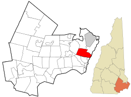 Location in Rockingham County and the state of New Hampshire. | |
| Coordinates: 42°58′21″N 70°49′47″W | |
| Country | United States |
| State | New Hampshire |
| County | Rockingham |
| Incorporated | November 30, 1742 |
| Villages | North Hampton North Hampton Center Cemetery Corners Fogg Corner Little Boars Head |
| Government | |
| • Board of Selectmen | Jim Maggiore, Chair Larry Miller Kathleen Kilgore |
| • Town Administrator | Bryan Kaenrath |
| Area | |
| • Total | 14.4 sq mi (37.3 km2) |
| • Land | 13.9 sq mi (36.0 km2) |
| • Water | 0.5 sq mi (1.3 km2) 3.47% |
| Elevation | 79 ft (24 m) |
| Population (2010) | |
| • Total | 4,301 |
| • Density | 300/sq mi (120/km2) |
| Time zone | UTC-5 (Eastern) |
| • Summer (DST) | UTC-4 (Eastern) |
| ZIP code | 03862 |
| Area code(s) | 603 |
| FIPS code | 33-54580 |
| GNIS feature ID | 0873687 |
| Website | www |
History
First settled in 1639, this town was a part of Hampton known as "North Hill" or "North Parish". Residents began petitioning for separation from Hampton as early as 1719, but township was not granted until 1742 by Colonial Governor Benning Wentworth, following separation of New Hampshire from Massachusetts. In 1831, North Hampton was represented in the New Hampshire House of Representatives by Benning Leavitt.[2]
Little Boar's Head, a seaside promontory, became a fashionable summer resort area in the 19th century, and contains elegant examples of late Victorian and Edwardian architecture.[3]
Geography
According to the United States Census Bureau, the town has a total area of 14.4 square miles (37 km2), of which 13.9 sq mi (36 km2) is land and 0.5 sq mi (1.3 km2) is water, comprising 3.47% of the town. The highest point in North Hampton is the summit of Pine Hill, at 160 feet (49 m) above sea level, on the town's western border. The town is drained to the east by the Little River and to the northwest by the Winnicut River.
U.S. Route 1 and state routes 1A and 151 run north-south through North Hampton, while 111 runs east-west. Interstate 95 runs through North Hampton without access to the town; Route 101 provides easier freeway access to North Hampton despite never entering the town. The nearest commercial airport is Portsmouth International Airport; the two closest major airports are Logan Airport in Boston and Portland International Jetport.
Adjacent municipalities
- Greenland, New Hampshire (north)
- Rye, New Hampshire (northeast)
- Hampton, New Hampshire (south)
- Stratham, New Hampshire (west)
Demographics
| Historical population | |||
|---|---|---|---|
| Census | Pop. | %± | |
| 1790 | 657 | — | |
| 1800 | 653 | −0.6% | |
| 1810 | 651 | −0.3% | |
| 1820 | 764 | 17.4% | |
| 1830 | 767 | 0.4% | |
| 1840 | 885 | 15.4% | |
| 1850 | 822 | −7.1% | |
| 1860 | 771 | −6.2% | |
| 1870 | 723 | −6.2% | |
| 1880 | 774 | 7.1% | |
| 1890 | 804 | 3.9% | |
| 1900 | 812 | 1.0% | |
| 1910 | 782 | −3.7% | |
| 1920 | 677 | −13.4% | |
| 1930 | 695 | 2.7% | |
| 1940 | 818 | 17.7% | |
| 1950 | 1,104 | 35.0% | |
| 1960 | 1,910 | 73.0% | |
| 1970 | 3,259 | 70.6% | |
| 1980 | 3,425 | 5.1% | |
| 1990 | 3,637 | 6.2% | |
| 2000 | 4,259 | 17.1% | |
| 2010 | 4,301 | 1.0% | |
| Est. 2017 | 4,456 | [4] | 3.6% |
| U.S. Decennial Census[5] | |||
As of the census[6] of 2000, there were 4,259 people, 1,671 households, and 1,234 families residing in the town. The population density was 306.3 people per square mile (118.2/km²). There were 1,782 housing units at an average density of 128.1 per square mile (49.5/km²). The racial makeup of the town was 98.40% White, 0.31% African American, 0.05% Native American, 0.63% Asian, 0.21% from other races, and 0.40% from two or more races. Hispanic or Latino of any race were 0.77% of the population.
There were 1,671 households out of which 29.8% had children under the age of 18 living with them, 64.6% were married couples living together, 7.0% had a female householder with no husband present, and 26.1% were non-families. 20.0% of all households were made up of individuals and 8.3% had someone living alone who was 65 years of age or older. The average household size was 2.55 and the average family size was 2.96.
In the town, the population was spread out with 23.3% under the age of 18, 4.4% from 18 to 24, 27.4% from 25 to 44, 30.5% from 45 to 64, and 14.3% who were 65 years of age or older. The median age was 42 years. For every 100 females, there were 95.3 males. For every 100 females age 18 and over, there were 94.3 males.
The median income for a household in the town was $66,696, and the median income for a family was $72,500. Males had a median income of $51,451 versus $31,512 for females. The per capita income for the town was $34,187. About 1.6% of families and 3.3% of the population were below the poverty line, including 0.7% of those under age 18 and 6.1% of those age 65 or over.
Notable people
- Henry Dearborn, general, US congressman from Massachusetts, and the 5th US Secretary of War
- Abraham Drake, commanded 2nd N.H. Militia during Saratoga campaign[7]
- Alvan T. Fuller, 50th governor of Massachusetts (summer residence)[8]
- Ogden Nash, poet; buried in North Hampton
- Bonnie Newman, politician[9]
- Herbert Philbrick, Boston ad executive; noted Cold War citizen spy for the FBI
Thoroughbreds
- Mom's Command and Dancer's Image were notable Thoroughbreds owned by Peter D. Fuller at Runnymede Farm in North Hampton; the former horse is buried there.[10] Both horses are featured on a billboard along NH Route 111.
Sites of interest
References
- United States Census Bureau, U.S. Census website, 2010 Census figures. Retrieved March 23, 2011.
- Rules and Orders of the Senate and House of Representatives of the State of New Hampshire, Published by Order of Both Houses, Printed by Hill and Barton, Concord, N.H., 1831
- "NRHP nomination for Little Boar's Head Historic District". National Park Service. Retrieved 2014-07-04.
- "Annual Estimates of the Resident Population: April 1, 2010 to July 1, 2017 (PEPANNRES): Minor Civil Divisions – New Hampshire". Archived from the original on February 13, 2020. Retrieved November 15, 2018.
- "Census of Population and Housing". Census.gov. Retrieved June 4, 2016.
- "U.S. Census website". United States Census Bureau. Retrieved 2008-01-31.
- State Builders: An Illustrated Historical and Biographical Record of the State of New Hampshire, 1903
- "Congratulating Fuller". The Portsmouth Herald. Portsmouth, New Hampshire. September 10, 1924. p. 1. Retrieved June 30, 2019 – via newspapers.com.
- Milne, John (June 21, 1987). "New breed of politician emerging in N.H." The Boston Globe. p. 50. Retrieved June 30, 2019 – via newspapers.com.
- Kane, Amy (February 16, 2007). "Last remembrance of champion horse". seacoastonline.com. Retrieved June 30, 2019.
External links
- Town of North Hampton official website
- North Hampton Public Library
- New Hampshire Economic and Labor Market Information Bureau Profile
Places adjacent to North Hampton, New Hampshire | |
|---|---|
Municipalities and communities of Rockingham County, New Hampshire, United States | ||
|---|---|---|
| City | 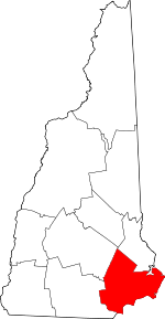 Map of New Hampshire highlighting Rockingham County | |
| Towns |
| |
| CDPs | ||
| Other villages | ||
| Authority control |
|
|---|