Interstate 93
Interstate 93 (I-93) is an Interstate Highway in the New England region of the United States. It begins in Canton, Massachusetts, in the Boston metropolitan area, at I-95;[3] and ends near St. Johnsbury, Vermont, at I-91.[4] It is one of three mainline Interstate highways located wholly within New England, the other two being I-89 and I-91. The largest cities along its route are Manchester, New Hampshire, and Boston, Massachusetts. It also passes through the New Hampshire state capital of Concord.
| ||||||||||||
|---|---|---|---|---|---|---|---|---|---|---|---|---|

I-93 highlighted in red | ||||||||||||
| Route information | ||||||||||||
| Length | 189.95 mi[1] (305.69 km) | |||||||||||
| Existed | 1957–present | |||||||||||
| Restrictions | No hazardous goods and cargo tankers between exits 18 and 26 in Massachusetts[2] | |||||||||||
| Major junctions | ||||||||||||
| South end | ||||||||||||
| ||||||||||||
| North end | ||||||||||||
| Location | ||||||||||||
| States | Massachusetts, New Hampshire, Vermont | |||||||||||
| Counties | MA: Norfolk, Suffolk, Middlesex, Essex NH: Rockingham, Hillsborough, Merrimack, Belknap, Grafton VT: Caledonia | |||||||||||
| Highway system | ||||||||||||
|
State highways in Vermont
| ||||||||||||

For most of its length, I-93 indirectly parallels U.S. Route 3. Particularly in New Hampshire, the two highways have several interchanges with each other, as well as a concurrency through Franconia Notch State Park. I-93 follows the Southeast Expressway south of downtown Boston, the Central Artery through Boston, and the Northern Expressway from Boston to the New Hampshire state line.
Route description
| mi[5][6][7] | km | |
|---|---|---|
| MA | 46.25 | 74.43 |
| NH | 131.764 | 212.054 |
| VT | 11.104 | 17.870 |
| Total | 189.118 | 304.356 |
Massachusetts
Interstate 93's southern terminus is at exit 12 of I-95 in Canton, co-signed with U.S. Route 1 North. At this junction, I-95 North heads to the northwest (co-signed with U.S. Route 1 South, as well as Route 128, which begins at the interchange), to serve as the beltway around Boston, while I-95 South runs by itself southwest through Boston's southwestern suburbs toward Rhode Island. This violates the numbering plan for the highway system of the United States, which dictates that the signed number for odd-numbered interstates increase from west to east, and therefore I-95 should be farther east than I-93.
The southernmost 3 miles (4.8 km) of I-93 run east through Boston's southern suburbs, passing through Canton and Randolph. In Randolph, I-93 meets the northern end of Route 24 (Fall River Expressway/AMVETS Memorial Highway) at Exit 4. I-93 continues east into Braintree, interchanging with Route 3, the major freeway linking Boston to Cape Cod, at Exit 7 (known locally as the "Braintree Split"). Route 3 North joins I-93 and US-1, and the highway turns north toward Boston. These first 7 miles (11 km) of I-93 follows what was formerly part of Massachusetts Route 128 before it was truncated at the I-95/I-93 junction and many locals still refer to this section of roadway as part of Route 128.

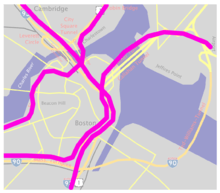
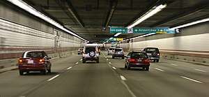
Upon turning northward, the highway is known as the Southeast Expressway passing through Quincy and Milton before crossing into the city of Boston over the Neponset River. After the Massachusetts Avenue connector exit, the highway officially becomes the John F. Fitzgerald Expressway, which is also known as the Central Artery, and passes beneath downtown Boston. A major intersection with the Massachusetts Turnpike/Interstate 90 (Exit 20) takes place just south of downtown Boston. After the massive interchange, motorists use the Thomas P. O'Neill Jr. Tunnel to travel underneath the city and then use Zakim Bunker Hill Bridge to cross the Charles River. Two exits are located in the tunnel, where the speed limit is 45 miles (72 km) an hour. Route 3 leaves the Artery just before the Zakim bridge via Exit 26, and U.S. Route 1 leaves the Artery just after the bridge, via Exit 27 (no southbound access). From Boston through the rest of Massachusetts, Concord, NH appears as the control city on northbound overhead signs. The Artery ends as I-93 continues north out of the city.
I-93 continues through the northern suburbs of Boston, coming to a second interchange with Interstate 95 and Route 128, which run concurrently. Travelers going north can either change over to I-95 north to eventually reach Maine, or remain on I-93 toward New Hampshire. Farther north, in Andover, I-93 meets I-495, providing access to Worcester to the southwest and New Hampshire's seacoast region to the northeast. Just south of the state line, I-93 crosses the Merrimack River into Methuen, where it interchanges with Routes 110 and 113 at exit 46 just north of the river crossing. Prior to August 2016, the Route 110 and 113 junction beneath I-93 was a rotary, but current construction routes the highways straight under I-93. While two new ramps are being built at the interchange to complete the new partial cloverleaf format, there are temporary signals and inlets at the end of two existing ramps to serve traffic that will soon be using the new loop ramps. Work began in July 2014, on the project, and with the rotary closed, demolition of the rotary will be underway in late 2016. The full project is scheduled for completion in June 2018.[8] I-93 then interchanges with the western end of Route 213, a connector between I-93 and I-495. I-93 then crosses into New Hampshire after about 1 mile (1.6 km).
In all, I-93 has 48 numbered exits in Massachusetts, although several numbers are skipped in and near Boston. One noteworthy reason that some exits were removed from I-93 is to further address traffic problems in addition to converting the Central Artery from six to eight to ten lanes, by reducing the combined number of on- and off-ramps from 27 to 14.[9] Exit 48 in Methuen, just before the New Hampshire state line, is the highest-numbered exit along the entire route. I-93 once had only 22 exits prior to the re-routing of I-95 onto MA 128.[10] Due to the highway being one of the two major Interstates that enter Boston directly (Interstate 90 is the other), nearly the entire length of the highway in Massachusetts carries four lanes in each direction. Average daily traffic volumes on I-93 in the state range from 100,000 vehicles at the New Hampshire border[11] and 150,000 vehicles at the southern end at I-95[12] to over 200,000 vehicles through Braintree and Quincy.[11]
New Hampshire
Interstate 93 travels just over 131 miles (211 km) in the Granite State, around two-thirds of the highway's total distance. Serving as the main interstate route in New Hampshire, it connects the state capital, Concord, and its largest city, Manchester. Beyond Concord are the towns of Tilton, Plymouth, and Littleton. I-93 is designated as the Alan B. Shepard Highway,[13] from the Massachusetts line to Hooksett (just north of Manchester at the northern terminus of I-293), as the F.E. Everett Turnpike from Hooksett to Concord, and as the Styles Bridges Highway from Concord to the Vermont line. This section of roadway was constructed between 1961 and 1977.
Between the northern end of I-293 in Hooksett and the beginning of I-89 in Bow, I-93 also carries the northern end of the Everett Turnpike. There is one toll booth along this section, at Exit 11 in Hooksett; the toll for passenger cars is $1 (50¢ at the ramp toll booth). This is the only toll collected along the entire length of Interstate 93. I-93 in New Hampshire is also notable for having state liquor stores serve as rest areas, which are passed just after the toll plaza, traveling north. There are separate stores on both sides of the Interstate for travelers in each direction.
I-93 enters New Hampshire at Salem. A rest area/welcome center is available on the northbound side of the freeway, directly before Exit 1. I-93 remains three lanes wide in each direction for its first 7 miles (11 km), until after the exit 3 interchange in Windham. It then drops to two lanes until the split with Interstate 293 and the junction with New Hampshire Route 101 add a third and fourth lane back to the freeway. I-93 and New Hampshire Route 101 run concurrently for about 1 mile (1.6 km) before New Hampshire Route 101 heads directly east as its own freeway, serving Portsmouth and the Seacoast region. I-93 keeps three lanes of traffic in each direction until the junction with Interstate 89, when each side reduces back to two, and remains a four-lane freeway through most of its journey northward, with the only exception being the Franconia Notch section.

It crosses the Merrimack River again before going through the state capital of Concord. In Concord, Interstate 393 heads directly east (co-signed with eastbound U.S. Route 4 and U.S. Route 202), providing another route to the Seacoast region. Westbound U.S. Route 4 joins I-93 and runs concurrently with it until Exit 17 for Penacook, about 5 miles (8.0 km) further north, before exiting westward. Continuing north, I-93 traverses the Lake Winnipesaukee tourist region and makes its way north through the heart of the White Mountains Region. I-93 passes through Franconia Notch State Park as a Super-2 parkway (one lane in each direction) with a 45 miles per hour (70 km/h) speed limit, designed to reduce I-93's impact on Franconia Notch. For the trip through Franconia Notch, I-93 and U.S. Route 3 run concurrently.
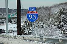
Beyond Franconia Notch State Park, U.S. 3 heads northeastward through the Great North Woods region, while I-93 runs to the northwest. The final town along I-93 in New Hampshire is Littleton, served by four exits. Many motorist services are available at Exit 42. After passing through town, it crosses the Connecticut River into Vermont. The last exit along I-93 is exit 44 for Monroe, through which a rest area/welcome center is accessible to travelers on both sides of the highway.
In 2013, a bill was signed by governor Maggie Hassan to raise the speed limit on Interstate 93 to 70 mph (115 km/h) from mile marker 45 to the Vermont border. The new limit took effect on January 1, 2014.
Vermont

Interstate 93 runs for 11 miles (18 km) in Vermont, with one numbered exit in the state before ending at the interchange with Interstate 91 in St. Johnsbury in the Northeast Kingdom of Vermont. A rest area/welcome center is located along the northbound side of the highway for travelers entering from New Hampshire. The final 3 miles (4.8 km) of the Interstate, just before its terminus, actually veer to the southwest. Vehicles bound for Canada can use northbound I-91 to reach the Derby Line/Stanstead border crossing at that Interstate's end, and northwards into Canada as an "autoroute" freeway into the Canadian province of Quebec. The portion of I-93 in Vermont parallels both U.S. Route 2 and Vermont Route 18.
History
Southeast Expressway
The Southeast Expressway was constructed between 1954 and 1959, at the same time the John F. Fitzgerald Expressway (Central Artery) was built. Its northern terminus is at Exit 18 (Massachusetts Avenue) in South Boston, a former Y-interchange where the cancelled Inner Belt (I-695) was to meet with the expressway and the Central Artery. The southern terminus is at the Y-interchange (the "Braintree Split") at Exit 7 in Braintree (the former southern terminus of Route 128). A section of the Expressway, beginning south of the Savin Hill overpass and ending just before the Braintree Split utilizes a zipper lane, in which a movable barrier carves out a reversible high occupancy vehicle lane on the non-peak side of the highway during rush hour. Most of the right of way for the Granite Railway in Milton and Quincy was incorporated into the expressway.[14]
Boston

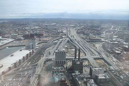
The Central Artery, officially the John F. Fitzgerald Expressway, was a section of highway in downtown Boston constructed in the 1950s and was originally designed as a fully elevated highway. This new highway was greatly disliked by the citizens of the city because it cut the heart of the city in half, cast long, dreary shadows and was an eyesore to the community. Because of the public outcry, Gov. John Volpe ordered the southern half of the highway redesigned so that it was underground; this section became known as the Dewey Square Tunnel. With the cancellation of the highway projects leading into the city in 1972 by Gov. Francis W. Sargent, the Central Artery gained the designation of Interstate 93 in 1974. It has also carried the local highway designations of U.S. 1 (since 1989) and Route 3.
By the mid-1970s, I-93 had outgrown its capacity and had begun to deteriorate due a lack of maintenance. State Transportation Secretary Frederick P. Salvucci, aware of the issues surrounding the elevated roadway, proposed a plan conceived in the early 1970s by the Boston Transportation Planning Review to replace the rusting elevated six-lane Central Artery with a new, more efficient underground roadway. This plan was merged with a long-standing proposal to build a third harbor tunnel to alleviate congestion in the Sumner and Callahan tunnels to East Boston; the new plan became known as the Central Artery/Tunnel Project or the Big Dig.
These new roadways were built during a twelve-year period from 1994 to early 2006. The massive project became the largest urban construction project ever undertaken in American history.[15] Construction on the new I-93 segment was not without serious issues: a lengthy Federal environmental review pushed the start of construction back from approximately 1990, causing many inflationary increases; funding for the project was the subject of several political battles between Pres. Ronald Reagan and Rep. Thomas P. O'Neill, Jr. Major construction on the new roadway was done while maintaining the old roadway, a step that also greatly increased the cost of the project. The original Charles River crossing, named Scheme Z, was the object to great public outcry similar to that of the building of the original highway. The outcry eventually led to the replacement of Scheme Z with a newer, more sleek cable-stayed bridge and complementing exit for Cambridge, increasing the cost even more.
In Downtown Boston, I-93 is made up of the Thomas P. O'Neill Jr. Tunnel and the Zakim Bunker Hill Bridge, which spans the Charles River. The underground construction of the tunnel system was completed as of October 2006; however, repairs continue to many parts of the tunnel due to water leakage because of improper construction of the slurry walls supporting the O'Neill tunnel. The former route of the above-ground Artery, so named "the other Green Monster" by Mayor Thomas Menino, was replaced mostly by open space known formally as the Rose Kennedy Greenway.
Additional improvements were done in the South Bay section of the highway: The I-90/I-93 interchange was completely redesigned, a new HOV lane extending from the zipper lane in Quincy was added and the South Boston Haul road that was constructed to bypass truck traffic around residential streets in the South End is open to general traffic.
Hazardous cargoes are prohibited from I-93 in Boston due to safety issues in the tunnels; these cargoes must exit at either the Leverett Circle connector when traveling southbound or at the Massachusetts Ave. exit when traveling northbound.
Northern Expressway
The Northern Expressway was constructed from Medford to the New Hampshire border between 1956 and 1963. It was extended through Somerville and Charlestown to the Central Artery, U.S. Route 1, and the planned route of the Inner Belt between 1965 and 1973. Because it was already under construction, the highway was granted an exception to the moratorium on highway expansion inside Route 128 which was announced in 1970.[16]
I-93's original southern terminus was in Cambridge (just north of Boston) where it was to meet the Inner Belt (I-695). However, when that route was canceled, and the I-95 section into Boston was canceled and rerouted along Route 128 in the mid-1970s, I-93's route was extended an additional 18 miles (29 km) down the Central Artery (which had been signed as a concurrency of I-95/MA-3 before I-95 was rerouted) and the Southeast Expressway (what was then just Route 3) from Boston to Braintree and then west along former Route 128 to its intersection with I-95 in Canton.
In an attempt to alleviate rush-hour traffic jams, travel in the breakdown lane of I-93 is permitted on a small stretch between Exit 41 and Exit 47/48. This extra travel is permitted on the southbound side on weekdays between 6AM and 10AM, and on the northbound side between 3PM and 7PM. However, on most busy days this fails to prevent traffic delays. The Massachusetts State Police is displeased with this arrangement, citing that traffic in the breakdown lanes interferes with the ability of emergency vehicles to respond to accidents.
Rapid bridge replacement project
In August 2010, in Medford, a 25-by-7-foot (7.6 m × 2.1 m) section of bridge deck on the northbound side partially collapsed due to age-related structural fatigue.[17] The collapse forced the Massachusetts Department of Transportation to evaluate the remaining bridges along the corridor, eventually deciding to replace several bridges along the highway in a plan called 93 Fast 14. The MassDOT set in motion a plan to replace the superstructure and concrete decks on 14 overpass bridges along that section of the interstate, using rapid bridge replacement methods. The $98.1 million project replaced bridges originally built in 1957 with a set of prefabricated modular concrete bridges in a series of weekend roadway closures. Traffic was diverted into a series of crossover lanes during construction. The main part of the project took place each weekend from June through August 2011,with the exception of the July 4th holiday weekend. One or two bridges were replaced each weekend during the construction time frame. The project was part of the Commonwealth's Accelerated Bridge Program.[18][19]
Methuen Rotary
Off exit 46 in Methuen, Massachusetts, the surface level traffic circle was rebuilt as part of an overall infrastructure improvement that also included constructing a new bridge carrying the interstate over the local road, reconstructing on- and off-ramps to the highway, and realigning the interstate itself.[20]
New Hampshire
Exit 1 in Salem was originally designed and built with ramps allowing northbound traffic to exit to Rockingham Park and return drivers to southbound 93 only. The complementary ramps were added much later, with the southbound off ramp being a particularly tight and dangerous turn squeezed within the curve of the southbound on ramp, which was replaced in August 2012.
A 7.6-mile (12 km) section of I-93 through Franconia Notch State Park, called the Franconia Notch Parkway, was constructed as a two-lane freeway with a median divider. This was built as a compromise between the state's park department and highway officials. The speed limit on the parkway is 45 mph (70 km/h). Originally, this section's signage read "U.S. 3 TO I-93", complete with its own exit number sequence, but this has since been replaced by I-93 and US-3 signage along the entire length of the parkway. The exits were renumbered to Exit 34A, 34B, and 34C. This section of the highway is the only remaining section of two-lane freeway on an Interstate highway in the United States.
Future expansion
Massachusetts plans
Since 1996, MassHighway has studied rebuilding the intersection of I-93 and I-95 in Woburn along the border with Stoneham and Reading.[23] The project was expected to start in Spring 2017 and cost $267 million, however continued community opposition has postponed the project indefinitely.[24] A project to upgrade the I-93/I-95 interchange in Canton is proposed.
An additional proposal around 2010, to upgrade MA Route 24, running southwards from I-93's Exit 4, to Interstate 195 near Fall River, MA also has been put off due to studies showing the cost of the project being very high.[25]
The Massachusetts Department of Transportation and its predecessor MassHighway have planned on widening I-93 to a uniform four travel lanes in both directions from the lane drop near Exit 41 in Wilmington to the New Hampshire border since the beginning of the 2000s.[26] The first section of widening will be done as part of the I-93 Tri-Town Interchange Project. The project will construct a new interchange in Wilmington. I-93 will be widened from 3 to 4 lanes in each direction from Exit 41 to I-495, a distance of approximately 5 miles (8 km), as the first phase in widening I-93 from Exit 41 to the New Hampshire state line. Early estimates of the entire project place the cost at $567 million.[27]
New Hampshire plans
Initial plans to widen I-93 to a uniform four travel lanes in both directions from Salem to Manchester beginning in 2008 were put on hold due to a lawsuit designed to force the New Hampshire Department of Transportation (NHDOT) to update the plans to include other transportation options. Under orders from US District Court, the NHDOT and US Department of Transportation must provide an updated environmental review. The Conservation Law Foundation (CLF) filed a lawsuit in February 2006, hoping to force any expansion plans in the area to include the restoration of commuter rail service between Manchester and Boston.[28] Despite the suit, the Exit 1 interchange construction was allowed to undergo upgrading and expansion; other associated projects related to the widening, chiefly around Exits 3 and 5, were also eventually allowed to proceed. The whole set of projects were eventually allowed to move forward when an agreement between the state and the CLF that removed the group's opposition to construction which does not pose a threat to the environment.[29]
As part of the 2009 stimulus package, New Hampshire was set to receive several million dollars in highway construction funds. One of the projects was the widening of a portion of the highway between the Massachusetts border and Manchester. Bidding was set to begin in February 2009 with construction slated to begin in late 2009 or early 2010.[30] The plans call for the New Hampshire Department of Transportation to widen the southernmost 20 miles (32 km) of I-93 to four lanes in each direction, from the two. In addition, all five interchanges along this length will be upgraded to accommodate larger amounts of traffic, including replacing many aging bridges. Smaller construction projects at some of the interchanges are already taking place.[29] According to plans filed by the state with US DOT, the project is scheduled to run from 2009 through 2016, with work starting at the Massachusetts line and moving northward to Manchester. The project is designed with an intermodal transit bent; new or improved park and ride facilities deployed at exits 1, 3 and 5 and a widened median strip that is designed to accommodate a planned commuter rail service between Boston and Manchester.[31]
As a way to help defray the costs of the expansion, in early 2010 the NHDOT made a formal request to the Federal Highway Administration to add tolls to I-93 at the Massachusetts-New Hampshire border. The new toll facility was to be located in Salem, New Hampshire, approximately .5 mi (0.80 km) from the state line, and would cost travelers $2 per car. The proposal faced opposition from state legislators in both states who claimed the tolls would cause severe congestion in the area and lead to an economic burden to local residents. Opponents included US senator Scott Brown (R-Massachusetts).[32] The proposal was eventually dropped in favor of issuing new state bonds to pay for expansion. The new policy was laid out by Transportation Commissioner George Campbell after reviewing the proposal and receiving a promise from the MassDOT that it would not be enacting a similar toll on the Massachusetts side of the border.[33]
Plans were announced in 2012 that I-93 would have a new northbound and southbound bridge over Interstate 89 in Bow. To reduce traffic on the southbound bridge the NHDOT added a third lane to ease congestion. The bridges were completed in 2014.
More plans were announced in 2014 that the Hooksett rest areas would be rebuilt. The new rest areas would feature a 14-pump Irving gas station, a new New Hampshire liquor and wine outlet, and a few restaurants and shops. The project was completed in 2015.
In Londonderry, a new Exit 4A and connector road to the town of Derry were in final planning stages as of June 2020. Construction of Exit 4A, to be located approximately a mile north of Exit 4 in Londonderry, was slated to begin construction in late 2020.[34]
Exit list
Exits 17, 19, 21, and 25 in Massachusetts were eliminated as part of the Big Dig. Massachusetts exit numbers were to be changed to those based on I-93 mileposts with a project that was due to start in early 2016, but this project was postponed by the MassDOT for several years.[35][36][37] On November 18, 2019, the MassDOT confirmed that beginning in late summer 2020 the exit renumbering project would begin.[36][37]
| State | County | Location [5][6][7][38] | mi [5][6][7][38] | km | Old exit [39][40] | New exit [37] | Destinations[39][40] | Notes |
|---|---|---|---|---|---|---|---|---|
| Massachusetts | Norfolk | Canton | 0.000– 0.267 | 0.000– 0.430 | 1 | 1 | Signed as exits 1A (south) and 1B (north);[37] southern terminus of US 1 concurrency; exit 12 (scheduled to be exit 26[41]) on I-95; southern terminus of Route 128 | |
| 1.415 | 2.277 | 2 | 2 | Signed as exits 2A (south) and 2B (north)[37] | ||||
| Milton | 2.615 | 4.208 | 3 | 3 | Ponkapoag Trail – Houghton's Pond | |||
| Randolph | 3.480 | 5.601 | 4 | 4 | Left exit and entrance southbound; northern terminus of Route 24; exit 21 (scheduled to be exit 41[42]) on Route 24 | |||
| 4.233 | 6.812 | 5 | 5 | Signed as exits 5A (south) and 5B (north)[37] | ||||
| Braintree | 6.450 | 10.380 | 6 | 6 | Northern terminus of Route 37 | |||
| 6.802 | 10.947 | 7 | 7 | Braintree Split; left exit and entrance southbound; southern terminus of Route 3 concurrency; former southern terminus of Route 128 | ||||
| South end of the Southeast Expressway | ||||||||
| Quincy | 8.182 | 13.168 | 8 | 8 | Furnace Brook Parkway – Quincy | |||
| Milton | 9.162 | 14.745 | 9 | 9 | Adams Street – Milton, North Quincy | Northbound signage | ||
| 9.410 | 15.144 | Bryant Avenue – West Quincy | Southbound signage | |||||
| 10.134 | 16.309 | 10 | 10 | Squantum Street – Milton | Southbound exit only[37] | |||
| 10.832 | 17.432 | 11A | 11A | Granite Avenue east – East Milton | Southbound exit and northbound entrance | |||
| 10.842 | 17.449 | 11B | 11B | Signed as exit 11 northbound; no northbound entrance | ||||
| Suffolk | Boston | 11.575 | 18.628 | 12 | 12 | No northbound exit[37] | ||
| 12.456 | 20.046 | 13 | 13A | Freeport Street – Dorchester | Northbound exit only[37] | |||
| 12.728 | 20.484 | 14 | 13B | Morrissey Boulevard – Savin Hill | Northbound exit and southbound entrance; commercial vehicles and buses prohibited | |||
| 14.343 | 23.083 | 15 | 14 | Columbia Road – Dorchester, South Boston | ||||
| 14.820 | 23.850 | 16 | 15A | Southampton Street – Andrew Square | Northbound exit and southbound entrance | |||
| 17 | Frontage Road | Former northbound exit removed during Big Dig reconstruction | ||||||
| 15.100– 15.929 | 24.301– 25.635 | 18 | 15 | Frontage Road / Massachusetts Avenue – Roxbury, Andrew Square | Signed as exit 15B northbound[37] | |||
| 19 | East Berkeley Street / Broadway / Albany Street | Closed as part of Big Dig reconstruction | ||||||
| North end of the Southeast Expressway, south end of the John F. Fitzgerald Expressway | ||||||||
| 15.340 | 24.687 | 20 | 16 | Northbound exit and southbound entrance; exits 24/24C (scheduled to be exits 134/134C[43]) on I-90 | ||||
| — | Northbound exit and southbound entrance to HOV lane | |||||||
| South end of the Thomas P. O'Neill Jr. Tunnel | ||||||||
| 17.253 | 27.766 | 20A 20B | 16A | Southbound exit and northbound left entrance | ||||
| Southbound exit and northbound entrance; exits 24/24B (scheduled to be exits 134/134B[43]) on I-90 | ||||||||
| 21 | Kneeland Street – Chinatown | Former southbound exit and northbound entrance; closed during Big Dig reconstruction | ||||||
| 16.694 | 26.866 | 22 | — | Surface Road – Chinatown | Southbound entrance only | |||
| 17.340 | 27.906 | 23 | 17 | Government Center | Northbound exit and southbound entrance via North Street | |||
| 17.487 | 28.143 | 23 | 16B | Purchase Street | Southbound exit and entrance only | |||
| 17.874 | 28.765 | 24A | 17A | Government Center | Southbound exit only; northbound entrance closed; formerly served Clinton Street | |||
| 24B | 17B | Southbound exit and northbound entrance | ||||||
| North end of the Thomas P. O'Neill Jr. Tunnel | ||||||||
| 25 | Causeway Street – North Station / Haymarket Square / Government Center | Closed as part of Big Dig reconstruction | ||||||
| Leonard P. Zakim Bunker Hill Memorial Bridge over the Charles River | ||||||||
| 17.892– 19.585 | 28.794– 31.519 | 26 | 18 | Leverett Connector; signed as Storrow Drive northbound; northern terminus of concurrency with Route 3 | ||||
| Charlestown High Bridge over the Charles River (demolished 2004 as part of Big Dig reconstruction; existed west of current alignment) | ||||||||
| 18.603 | 29.939 | 27 | 19 | Northbound left exit and southbound entrance; northern terminus of concurrency with US 1 | ||||
| North end of the John F. Fitzgerald Expressway | ||||||||
| Middlesex | Somerville | 19.230 | 30.948 | 28 | 20 | Northbound exit only, partially in Boston | ||
| 20.415 | 32.855 | Sullivan Square, Charlestown, Assembly Square | Southbound exit and northbound entrance | |||||
| 20.259 | 32.604 | 29 | 21 | Northbound exit and southbound entrance; southern terminus of Route 38 | ||||
| Medford | 21.323 | 34.316 | 30 | 21 | Southbound exit and northbound entrance | |||
| 21.743 | 34.992 | 31 | 22 | Northbound signage | ||||
| 21.859 | 35.179 | Southbound signage | ||||||
| 22.554 | 36.297 | 32 | 23 | Also to Route 16 southbound; to Tufts University's Medford/Somerville Campus | ||||
| 23.229 | 37.383 | 33 | 24 | Roosevelt Circle | ||||
| Stoneham | 25.276 | 40.678 | 34 | 25 | Northbound exit and southbound entrance | |||
| 26.087 | 41.983 | 35 | 26 | Park Street – Stoneham, Melrose | Southbound exit and northbound entrance | |||
| Woburn | 26.929 | 43.338 | 36 | 27 | Montvale Avenue – Stoneham, Woburn | |||
| Reading | 28.476 | 45.828 | 37A-B | 28 | Split into exits 37A (north) and 37B (south);[37] exits 37A-B (scheduled to be exits 55A-B[41]) on I-95 / Route 128 | |||
| Woburn | 29.965 | 48.224 | 37C | 30 | Commerce Way / Atlantic Avenue – Anderson RTC | |||
| Wilmington | 31.136 | 50.109 | 38 | 31 | ||||
| 32.635 | 52.521 | 39 | 33 | Concord Street – Wilmington | ||||
| 34.064 | 54.821 | 40 | 34 | |||||
| 34.629 | 55.730 | 41 | 35 | |||||
| Essex | Andover | 37.682 | 60.643 | 42 | 38 | Dascomb Road – Tewksbury, Andover | ||
| 39.196 | 63.080 | 43 | 39 | Signed as exits 43A (east) and 43B (west) southbound[37] | ||||
| 40.521 | 65.212 | 44 | 40 | Split into exits 44A (north) and 44B (south);[37] exits 40A-B (scheduled to be exits 97A-B[45]) on I-495 | ||||
| 42.423 | 68.273 | 45 | 42 | River Road – South Lawrence | ||||
| Merrimack River | 43.139 | 69.425 | General Edward D. Sirois Memorial Bridge | |||||
| Methuen | 43.465 | 69.950 | 46 | 43 | Interchange rebuilt in 2017; signed as exits 46A (east) and 46B (west) northbound[37][8] | |||
| 45.113 | 72.602 | 47 | 45 | Pelham Street | ||||
| 45.483 | 73.198 | 48 | 46 | Western terminus of Route 213; exits 1A/1B on Route 213 | ||||
| 46.25 0.000 | 74.43 0.000 | Massachusetts–New Hampshire line | ||||||
| New Hampshire | Rockingham | Salem | ||||||
| 1.368 | 2.202 | 1 | Originally northbound exit, southbound entrance only | |||||
| 3.001 | 4.830 | 2 | ||||||
| Windham | 5.821 | 9.368 | 3 | |||||
| Londonderry | 11.341 | 18.252 | 4 | |||||
| 12 | 19 | 4A | New connector road to Folsom Road, Derry | Future interchange[46] | ||||
| Rockingham | Londonderry | 15.291 | 24.608 | 5 | ||||
| Hillsborough | Manchester | 18.488 | 29.754 | — | Southern terminus of I-293; Southern terminus of concurrency with NH 101 | |||
| 20.591 | 33.138 | 6 | Candia Road / Hanover Street | Northbound entrance to NH 101 East only; Southbound exit from I-93 only | ||||
| 20.967 | 33.743 | 7 | Northern terminus of concurrency with NH 101 | |||||
| 22.093 | 35.555 | 8 | ||||||
| Merrimack | Hooksett | 23.922 | 38.499 | 9 | Split into exits 9N (north) and 9S (south) | |||
| 25.727 | 41.404 | 10 | ||||||
| 26.689 | 42.952 | — | Northern terminus of I-293; Southern terminus of concurrency with the Everett Turnpike | |||||
| 28.659 | 46.122 | Hooksett Main Toll Plaza | ||||||
| 28.751 | 46.270 | 11 | Hooksett Ramp Toll Plaza | |||||
| Bow | 35.495 | 57.124 | — | Southern terminus of I-89 | ||||
| Concord | 35.977 | 57.899 | 12 | Split into exits 12S (south) and 12N (north) | ||||
| 37.331 | 60.078 | 13 | ||||||
| 38.454 | 61.886 | 14 | Northern terminus of the Everett Turnpike Southern terminus of Styles Bridges Highway | |||||
| 38.977 | 62.727 | 15E | Western terminus of I-393; Southern terminus of concurrency with US 4 | |||||
| 15W | ||||||||
| 40.188 | 64.676 | 16 | ||||||
| 44.582 | 71.748 | 17 | Northern terminus of concurrency with US 4; signed as exits 17W and 17E going southbound | |||||
| Canterbury | 47.869 | 77.038 | 18 | |||||
| Northfield | 54.976 | 88.475 | 19 | Northbound exit and southbound entrance | ||||
| Belknap | Tilton | 56.907 | 91.583 | 20 | ||||
| Sanbornton | 61.159 | 98.426 | 22 | |||||
| New Hampton | 69.229 | 111.413 | 23 | |||||
| Grafton | Ashland | 75.308 | 121.196 | 24 | ||||
| Holderness | 79.992 | 128.735 | 25 | |||||
| Plymouth | 80.877 | 130.159 | 26 | Northern terminus of Route 3A | ||||
| Campton | 83.762 | 134.802 | 27 | |||||
| 86.819 | 139.722 | 28 | ||||||
| Thornton | 88.542 | 142.495 | 29 | |||||
| Woodstock | 94.400 | 151.922 | 30 | |||||
| 97.334 | 156.644 | 31 | ||||||
| 100.499 | 161.737 | 32 | ||||||
| Lincoln | 102.538 | 165.019 | 33 | |||||
| South end of the Franconia Notch Parkway | ||||||||
| 104.315– 106.006 | 167.879– 170.600 | 1 | 34A | Southern terminus of concurrency with US 3; No southbound entrance | ||||
| Franconia | 110.158 | 177.282 | 2 | 34B | Cannon Mountain Tramway – Old Man Historic Site | |||
| 110.858 | 178.409 | 3 | 34C | Southern terminus of NH 18 | ||||
| 111.401 | 179.283 | North end of the Franconia Notch Parkway | ||||||
| 112.315 | 180.753 | 35 | Northern terminus of concurrency with US 3; northbound exit and southbound entrance | |||||
| 112.947 | 181.771 | 36 | ||||||
| 115.946 | 186.597 | 37 | Northbound exit and southbound entrance | |||||
| 116.728 | 187.856 | 38 | NH 142 not signed northbound | |||||
| Bethlehem | 119.295 | 191.987 | 39 | Southbound exit and northbound entrance | ||||
| 120.777 | 194.372 | 40 | ||||||
| Littleton | 122.418 | 197.013 | 41 | |||||
| 124.397 | 200.198 | 42 | ||||||
| 126.129 | 202.985 | 43 | ||||||
| 130.355 | 209.786 | 44 | ||||||
| Connecticut River | 131.764 0.000 | 212.054 0.000 | Senator Andrew Poulsen Bridge[6] New Hampshire–Vermont line | |||||
| Vermont | Caledonia | Waterford | 7.510 | 12.086 | 1 | |||
| 11.104 | 17.870 | Exit 19 on I-91 | ||||||
1.000 mi = 1.609 km; 1.000 km = 0.621 mi
| ||||||||
Auxiliary routes
- Manchester, New Hampshire—I-293: The southernmost portion of this highway, between I-93 and the Everett Turnpike, was once known as Interstate 193.
- Concord, New Hampshire—I-393
References
- Federal Highway Administration (October 31, 2002). "FHWA Route Log and Finder List: Table 1". Retrieved March 28, 2007.
- "Hazardous material route designation". Mass.gov. Retrieved January 15, 2018.
- Google (June 8, 2009). "Interstate 93" (Map). Google Maps. Google. Retrieved June 8, 2009.
- Google (June 8, 2009). "Interstate 93" (Map). Google Maps. Google. Retrieved June 8, 2009.
- MassDOT Planning Division. "Massachusetts Route Log Application". Massachusetts Department of Transportation. Archived from the original on August 26, 2014. Retrieved August 23, 2014.
- Bureau of Planning & Community Assistance (February 20, 2015). "NH Public Roads". Concord, New Hampshire: New Hampshire Department of Transportation. Retrieved April 7, 2015.
- Traffic Research Unit (May 2013). "2012 (Route Log) AADTs for State Highways" (PDF). Policy, Planning and Intermodal Development Division, Vermont Agency of Transportation. Retrieved March 7, 2015.
- "Methuen Rotary Project: Home". Massachusetts Department of Transportation (MassDOT). Retrieved December 8, 2012.
- "404". Massachusetts Department of Transportation. Retrieved September 25, 2014.
- "Alps' Roads I-93 Photos". Alps' Roads. Retrieved November 18, 2012.
- "Traffic Counts for Rte. I-93". Massachusetts Highway Department. Archived from the original on July 21, 2009. Retrieved September 14, 2008.
- "Traffic Counts for Rte. 1 & I-93". Massachusetts Highway Department. Archived from the original on February 10, 2012. Retrieved September 14, 2008.
- "Alan B Shepard Highway (I-93)". Retrieved September 25, 2014.
- "The Successor Railroads". Thomas Crane Library. Retrieved September 12, 2017.
- "Review Begins After Big Dig Tunnel Collapse". CNN. July 12, 2006. Archived from the original on July 15, 2006. Retrieved July 25, 2006.
- "Northern Expressway (I-93)". Retrieved October 4, 2014.
- Moskowitz, Eric (August 4, 2010). "Officials expect I-93 north lanes in Medford to be open for a.m. commute". Boston Globe. Retrieved August 5, 2010.
- "I-93 Medford Bridges: 93Fast14 Video". Massachusetts Department of Transportation. May 5, 2011. Retrieved June 20, 2011.
- "MassDot Accelerated Bridge Program: About the program". Massachusetts Department of Transportation. Archived from the original on June 8, 2011. Retrieved June 20, 2011.
- Kashinsky, Leah (December 21, 2017). "MassDOT: 'Majority of construction' complete at former Methuen rotary". The Eagle-Tribune. North Andover, Massachusetts.
- "Vermont @ AARoads - Interstate 93". www.aaroads.com. Retrieved May 22, 2017.
- "Everett Turnpike (US 3, I-293, and I-93)". www.bostonroads.com. Retrieved May 22, 2017.
- "I-93\I-95 Interchange Transportation Study". Retrieved October 4, 2014.
- https://web.archive.org/web/20130616015526/http://www.mhd.state.ma.us/ProjectInfo/Main.asp?ACTION=ViewProject&PROJECT_NO=605605, archived from the original on June 16, 2013 Missing or empty
|title=(help) - Timmins, Steve. "personal correspondence" (Microsoft Word DOC). Mass Highway.
- "I-93/Lowell Junction Development Area Background". Archived from the original on July 2, 2014. Retrieved October 4, 2014.
- Anderson, Steve. "Northern Expressway". BostonRoads.com. Retrieved May 22, 2010.
- James Vaznis (August 31, 2007). "I-93 widening in N.H. set back". The Boston Globe. Retrieved October 14, 2007.
- Davidson, Kate (August 24, 2008). "I-93 projects move forward, not sideways". Concord Monitor. Retrieved September 13, 2008.
- John Distaso (February 18, 2009). "NH hustles for its slice of stimulus pie". New Hampshire Union Leader. MSNBC. Archived from the original on February 20, 2009. Retrieved February 20, 2009.
The biggest project on its list, the $31 million widening of Interstate 93 from Salem to Manchester, will be advertised on Feb. 24, Jannelle said.
- NH Department of Transportation. "Rebuilding 93:Salem to Manchester – Project background". NH DOT. Retrieved August 23, 2009.
- Date, Terry (February 23, 2010). "NH, Massachusetts lawmakers speak against I-93 toll". Eagle-Tribune. Retrieved May 22, 2010.
- Landrigan, Kevin (March 20, 2010). "Tolls nixed to pay for I-93 widening". Nashua Telegraph. Retrieved May 22, 2010.
- NH Department of Transportation. "I93 Exit 4A Project". NH DOT. Retrieved June 24, 2020.
- Commonwealth of Massachusetts (November 17, 2015). "608024 - STATEWIDE "Exit Signage Conversion to Milepost-Based Numbering System along Various Interstates, Routes and the Lowell Connector"". Retrieved August 9, 2016.
- "Milepost-based Exit Renumbering" (PDF). Massachusetts Department of Transportation. December 5, 2019. Retrieved December 5, 2019.
- "I-93 Renumbering" (PDF). Massachusetts Department of Transportation. December 5, 2019. Retrieved December 5, 2019.
- Bureau of Planning & Community Assistance (April 3, 2015). "Nodal Reference 2015, State of New Hampshire". New Hampshire Department of Transportation. Retrieved April 7, 2015.
- Town of Salem, Rockingham County
- Town of Windham, Rockingham County
- Town of Londonderry, Rockingham County
- City of Manchester, Hillsborough County
- Town of Hooksett, Merrimack County
- Town of Bow, Merrimack County
- Town of Canterbury, Merrimack County
- Town of Northfield, Merrimack County
- Town of Tilton, Belknap County
- Town of Sanbornton, Belknap County
- Town of New Hampton, Belknap County
- Town of Ashland, Grafton County
- Town of Holderness, Grafton County
- Town of Plymouth, Grafton County
- Town of Campton, Grafton County
- Town of Thornton, Grafton County
- Town of Woodstock, Grafton County
- Town of Lincoln, Grafton County
- Town of Franconia, Grafton County
- Town of Bethlehem, Grafton County
- Town of Littleton, Grafton County
- Massachusetts Department of Transportation. "Exit Numbers and Names: Route I-93 (Canton to Route US 1)". Archived from the original on August 26, 2014. Retrieved August 23, 2014.
- "Exit Numbers and Names: Route I-93 (Route US 1 to Methuen)". Massachusetts Department of Transportation. Archived from the original on August 26, 2014. Retrieved August 23, 2014.
- "I-95 Renumbering" (PDF). Massachusetts Department of Transportation. December 5, 2019. Retrieved December 5, 2019.
- "Route 24 and Route 25 Renumbering" (PDF). Massachusetts Department of Transportation. December 5, 2019. Retrieved December 5, 2019.
- "I-90 Renumbering" (PDF). Massachusetts Department of Transportation. December 5, 2019. Retrieved December 5, 2019.
- Google Maps (September 2013). "Street View". Retrieved August 23, 2014.
- "I-495 Renumbering" (PDF). Massachusetts Department of Transportation. December 5, 2019. Retrieved December 5, 2019.
- "I-93 Exit 4A Project". New Hampshire Department of Transportation. Retrieved June 24, 2020.
| Wikimedia Commons has media related to Interstate 93. |
| Signed | |
|---|---|
| Unsigned | |
| Lists | |
| Other | |
Major Interstates highlighted | |
1Former | ||