Atkinson, New Hampshire
Atkinson is a town in Rockingham County, New Hampshire, United States. The population was 6,751 at the 2010 census.[2]
Atkinson, New Hampshire | |
|---|---|
 Main Street | |
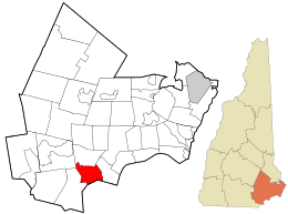 Location in Rockingham County and the state of New Hampshire. | |
| Coordinates: 42°50′18″N 71°08′49″W | |
| Country | United States |
| State | New Hampshire |
| County | Rockingham |
| Incorporated | 1767[1] |
| Villages | Atkinson Atkinson Heights |
| Government | |
| • Board of Selectmen | William G. Friel, Chair Jason B. Grosky Gregory S. Spero William M. Baldwin Harold J. Morse |
| • Town Administrator | David Cressman |
| Area | |
| • Total | 11.3 sq mi (29.3 km2) |
| • Land | 11.2 sq mi (28.9 km2) |
| • Water | 0.2 sq mi (0.4 km2) 1.42% |
| Elevation | 302 ft (92 m) |
| Population (2010) | |
| • Total | 6,751 |
| • Estimate (2017) | 6,901 |
| • Density | 619/sq mi (239.1/km2) |
| Time zone | UTC-5 (Eastern) |
| • Summer (DST) | UTC-4 (Eastern) |
| ZIP code | 03811 |
| Area code(s) | 603 |
| FIPS code | 33-02340 |
| GNIS feature ID | 0873535 |
| Website | www |
History
Atkinson's history dates back to the American Revolution. The community was incorporated 3 September[3][4] 1767,[1][5] and was named after Colonel Theodore Atkinson,[3] a local landowner.[6]
Atkinson Academy, the second-oldest co-educational school in the country,[7] was founded as a boys' school in 1787 by Reverend Stephen Peabody, General Nathaniel Peabody and Doctor William Cogswell; it began admitting girls in 1791. The school building burnt to the ground in 1802, and was rebuilt in 1803 at a cost of $2,500. That building remains a part of the Academy, which has since been expanded, with only four classrooms. Other historic buildings include the Atkinson Historical Society, the Kimball Public Library, and the Rockwell School (current police station).
Atkinson's history can be read about in the book Atkinson Then and Now, which can be purchased at the Atkinson Public Library on Academy Avenue.
Atkinson celebrated its 250-year anniversary Labor Day weekend 2017.[8]
Geography
According to the United States Census Bureau, the town has a total area of 11.3 square miles (29.3 km2), of which 11.2 square miles (28.9 km2) are land and 0.2 square miles (0.4 km2) are water, comprising 1.42% of the town. The highest point in Atkinson is Hog Hill, at 430 feet (130 m) above sea level. Atkinson lies fully within the Merrimack River watershed.[9]
In 2011 the New Hampshire Scenic and Cultural Byways program named 3.74 miles of Main Street the "Stage Coach Byway".[10]
Adjacent municipalities
- Hampstead, New Hampshire (north)
- Plaistow, New Hampshire (east)
- Haverhill, Massachusetts (south)
- Salem, New Hampshire (west)
- Derry, New Hampshire (northwest)
Demographics
| Historical population | |||
|---|---|---|---|
| Census | Pop. | %± | |
| 1790 | 479 | — | |
| 1800 | 474 | −1.0% | |
| 1810 | 556 | 17.3% | |
| 1820 | 563 | 1.3% | |
| 1830 | 555 | −1.4% | |
| 1840 | 567 | 2.2% | |
| 1850 | 600 | 5.8% | |
| 1860 | 546 | −9.0% | |
| 1870 | 488 | −10.6% | |
| 1880 | 502 | 2.9% | |
| 1890 | 483 | −3.8% | |
| 1900 | 442 | −8.5% | |
| 1910 | 440 | −0.5% | |
| 1920 | 413 | −6.1% | |
| 1930 | 407 | −1.5% | |
| 1940 | 434 | 6.6% | |
| 1950 | 492 | 13.4% | |
| 1960 | 1,017 | 106.7% | |
| 1970 | 2,291 | 125.3% | |
| 1980 | 4,397 | 91.9% | |
| 1990 | 5,188 | 18.0% | |
| 2000 | 6,178 | 19.1% | |
| 2010 | 6,751 | 9.3% | |
| Est. 2017 | 6,901 | [11] | 2.2% |
| U.S. Decennial Census[12] | |||
As of the census[13] of 2000, there were 6,178 people, 2,317 households, and 1,777 families residing in the town. The population density was 555.2 people per square mile (214.3/km2). There were 2,431 housing units at an average density of 218.5 per square mile (84.3/km2). The racial makeup of the town was 97.62% White, 0.26% African American, 0.06% Native American, 1.18% Asian, 0.21% from other races, and 0.66% from two or more races. Hispanic or Latino of any race were 0.70% of the population.
There were 2,317 households, out of which 32.5% had children under the age of 18 living with them, 68.8% were married couples living together, 5.7% had a female householder with no husband present, and 23.3% were non-families. 19.0% of all households were made up of individuals, and 6.4% had someone living alone who was 65 years of age or older. The average household size was 2.66 and the average family size was 3.08.
In the town, the population was spread out, with 24.5% under the age of 18, 5.0% from 18 to 24, 28.4% from 25 to 44, 30.7% from 45 to 64, and 11.4% who were 65 years of age or older. The median age was 41 years. For every 100 females, there were 94.9 males. For every 100 females age 18 and over, there were 96.1 males.
The median income for a household in the town was $69,729, and the median income for a family was $77,631. Males had a median income of $53,229 versus $34,760 for females. The per capita income for the town was $30,412. About 2.3% of families and 3.3% of the population were below the poverty line, including 4.5% of those under age 18 and 2.2% of those age 65 or over.
Arts and culture
Museums and other points of interest
The Kimball House Museum was built in 1772 by Reverend Stephen Peabody. It served as a medical office and town library before becoming a museum.[14]
Education
Atkinson Public Schools are part of the Timberlane Regional School District. The district serves the communities of Atkinson, Danville, Plaistow and Sandown. The district has five elementary schools, a middle school and a high school. Students in Atkinson attend Atkinson Academy, Timberlane Regional Middle School, and Timberlane Regional High School.[15][16]
Notable people
- Brad Delp (1951–2007), lead singer of Boston and RTZ[17]
- John Noyes (1764–1841), member of the United States House of Representatives from Vermont.
- Elizabeth Barrows Ussher (1873-1915), Christian missionary and witness of the Armenian Genocide
References
- "Atkinson, New Hampshire". City-Data.com. Retrieved November 10, 2012.
- United States Census Bureau, U.S. Census website, 2010 Census figures. Retrieved March 23, 2011.
- Article in Statistics and Gazetteer of New-Hampshire (1875)
- Article in Hayward’s New England Gazetteer (1839)
- "Town of Atkinson New Hampshire". Town of Atkinson New Hampshire. Retrieved November 10, 2012.
- "Profile for Atkinson, New Hampshire, NH". ePodunk. Retrieved November 10, 2012.
- Montalto, Jim (July 28, 2006). "School to many of Atkinson's own". The Eagle-Tribune. Retrieved 2009-12-21.
- "Celebrate Atkinson". atkinsonnh250th.com. Retrieved August 30, 2017.
- Foster, Debra H.; Batorfalvy, Tatianna N.; Medalie, Laura (1995). Water Use in New Hampshire: An Activities Guide for Teachers. U.S. Department of the Interior and U.S. Geological Survey.
- Hogan, Cara (August 3, 2011). "Atkinson's Main Street earns special designation". Eagle Tribune. Retrieved April 24, 2013.
- "Annual Estimates of the Resident Population: April 1, 2010 to July 1, 2017 (PEPANNRES): Minor Civil Divisions – New Hampshire". Archived from the original on February 13, 2020. Retrieved November 15, 2018.
- "Census of Population and Housing". Census.gov. Retrieved June 4, 2016.
- "U.S. Census website". United States Census Bureau. Retrieved 2008-01-31.
- "Kimball House Museum/Library History". Atkinson NH Historical Society. Archived from the original on August 12, 2013. Retrieved November 10, 2012.
- "Timberlane Regional School District". Timberlane Regional School District. Retrieved November 10, 2012.
- "Timberlane Regional School District". education.com. Retrieved November 10, 2012.
- Pareles, Jon (2007-03-10). "Brad Delp, 55, Lead Singer for Boston, Dies". The New York Times. ISSN 0362-4331. Retrieved 2016-03-30.
External links
| Wikimedia Commons has media related to Atkinson, New Hampshire. |
- Town of Atkinson official website
- AtkinsonWeather.com
- New Hampshire Economic and Labor Market Information Bureau Profile
- Timberlane Regional School District
- Atkinson Academy, Grades 1-5
- Timberlane Regional Middle School, Grades 6-8, located in Plaistow
- Timberlane Regional High School, Grades 9-12, located in Plaistow
- City-Data.com
- ePodunk: Profile for Atkinson, New Hampshire
Places adjacent to Atkinson, New Hampshire | |
|---|---|
Municipalities and communities of Rockingham County, New Hampshire, United States | ||
|---|---|---|
| City |  Map of New Hampshire highlighting Rockingham County | |
| Towns |
| |
| CDPs | ||
| Other villages | ||
| Authority control |
|
|---|