Bow, New Hampshire
Bow is a town in Merrimack County, New Hampshire, United States. The population was 7,519 at the 2010 census.[1]
Bow, New Hampshire | |
|---|---|
 Bow Center School (1894) | |
 Seal | |
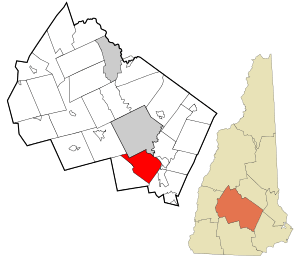 Location in Merrimack County and the state of New Hampshire | |
| Coordinates: 43°07′55″N 71°32′57″W | |
| Country | United States |
| State | New Hampshire |
| County | Merrimack |
| Incorporated | 1727 |
| Villages | Bow Mills Bow Center Bow Bog |
| Government | |
| • Board of Selectmen | Christopher Nicolopoulos, Chair Colleen Hunter Harold Judd Matthew Poulin Mike Wayne |
| • Town Manager | David Stack |
| Area | |
| • Total | 28.4 sq mi (73.6 km2) |
| • Land | 28.0 sq mi (72.6 km2) |
| • Water | 0.4 sq mi (1.0 km2) 1.38% |
| Elevation | 597 ft (182 m) |
| Population (2010) | |
| • Total | 7,519 |
| • Density | 268.5/sq mi (103.7/km2) |
| Time zone | UTC-5 (Eastern) |
| • Summer (DST) | UTC-4 (Eastern) |
| ZIP code | 03304 |
| Area code(s) | 603 |
| FIPS code | 33-06500 |
| GNIS feature ID | 0873548 |
| Website | www |
History
The town was granted by the authorities of New Hampshire, to Jonathan Wiggin and others, in 1727, and was originally 9 miles (14 km) square, and covered nearly all the territory granted to Ebenezer Eastman and others, by the authorities of Massachusetts, two years previous, under the name of Pennacook (now Concord). Massachusetts claimed to hold authority over a large portion of the territory of New Hampshire for many years, till the final boundary line was established, in 1741, giving New Hampshire more territory than it had ever claimed. These complicated lines of the two towns coming from two different authorities, were not settled decisively till after the final separation of the two colonial provinces. The government of New Hampshire gave Bow the preference in its grant of 1727, and did not recognize the title of the Pennacook grantees, and in the bill giving a charter for the parish of Concord, it was worded as "taking a part of the town of Bow," etc. Although Concord was granted and surveyed before Bow, its final organization was 38 years after it. Bow gained a victory over Concord in its original title; still it was obliged to yield over two-thirds of its territory to Concord, Pembroke and Hopkinton, establishing their final boundary lines at different times, from 1759 to 1765.[2]
The town's name comes from its establishment along a bend, or "bow", in the Merrimack River. The first census, taken in 1790, reported 568 residents.[3]
In 1874, the Concord Railroad passed along the eastern border of Bow.[2] It is now the New England Southern Railroad.
On September 28, 2019, hundreds of climate activists protested in Bow against Merrimack Station, one of the last remaining coal-fired power plants in New England. 67 people, who carried buckets signifying their intent to physically remove coal from the site, were arrested by state police.[4]
Geography
According to the United States Census Bureau, the town has a total area of 28.4 square miles (73.6 km2), of which 28.0 sq mi (72.6 km2) is land and 0.39 sq mi (1.0 km2) is water, comprising 1.38% of the town.[1] The highest point in Bow is Picked Hill, at 915 feet (279 m) above sea level, in the southern part of town. Nearby Wood Hill and Brown Hill also top 900 feet (270 m). Bow lies fully within the Merrimack River watershed.[5]
Adjacent municipalities
- Concord, New Hampshire (north)
- Pembroke, New Hampshire (northeast)
- Allenstown, New Hampshire (east)
- Hooksett, New Hampshire (southeast)
- Dunbarton, New Hampshire (southwest)
- Hopkinton, New Hampshire (northwest)
Demographics
| Historical population | |||
|---|---|---|---|
| Census | Pop. | %± | |
| 1790 | 568 | — | |
| 1800 | 719 | 26.6% | |
| 1810 | 729 | 1.4% | |
| 1820 | 935 | 28.3% | |
| 1830 | 1,065 | 13.9% | |
| 1840 | 1,001 | −6.0% | |
| 1850 | 1,055 | 5.4% | |
| 1860 | 909 | −13.8% | |
| 1870 | 745 | −18.0% | |
| 1880 | 734 | −1.5% | |
| 1890 | 725 | −1.2% | |
| 1900 | 617 | −14.9% | |
| 1910 | 676 | 9.6% | |
| 1920 | 568 | −16.0% | |
| 1930 | 780 | 37.3% | |
| 1940 | 942 | 20.8% | |
| 1950 | 1,062 | 12.7% | |
| 1960 | 1,340 | 26.2% | |
| 1970 | 2,479 | 85.0% | |
| 1980 | 4,015 | 62.0% | |
| 1990 | 5,500 | 37.0% | |
| 2000 | 7,138 | 29.8% | |
| 2010 | 7,519 | 5.3% | |
| Est. 2017 | 7,815 | [6] | 3.9% |
| U.S. Decennial Census[7] | |||
At the 2000 census there were 7,138 people in 2,304 households, including 2,045 families, in the town. The population density was 254.3 people per square mile (98.2/km²). There were 2,330 housing units at an average density of 83.0 per square mile (32.0/km²). The racial makeup of the town was 97.79% White, 0.13% African American, 0.10% Native American, 1.04% Asian, 0.29% from other races, and 0.66% from two or more races. Hispanic or Latino of any race were 0.49%.[8]
Of the 2,304 households 49.1% had children under the age of 18 living with them, 81.0% were married couples living together, 5.9% had a female householder with no husband present, and 11.2% were non-families. 8.6% of households were one person and 3.6% were one person aged 65 or older. The average household size was 3.10 and the average family size was 3.28.
The age distribution was 32.6% under the age of 18, 4.4% from 18 to 24, 27.3% from 25 to 44, 27.2% from 45 to 64, and 8.4% 65 or older. The median age was 39 years. For every 100 females, there were 99.5 males. For every 100 females age 18 and over, there were 93.7 males.
The median household income was $79,329 and the median family income was $83,567. Males had a median income of $60,375 versus $30,929 for females. The per capita income for the town was $29,557. About 2.0% of families and 1.8% of the population were below the poverty line, including 0.6% of those under age 18 and 4.2% of those age 65 or over.
Education
In 1997, Bow built its first high school, Bow High School, along Turee Pond. Bow Memorial School (the middle school) and Bow Elementary School are located on Bow Center Road, less than a mile from the high school.
Notable people
- Jamie Aube (b. 1957), NASCAR driver
- Mary Baker Eddy (1821–1910), founder of the Church of Christ, Scientist; born in Bow
- Sam Knox (1910–1981), American football player
- John Ordway (1775–1817), member of the Lewis and Clark Expedition
- Caleb Scofield (1979-2018), bassist/vocalist for Cave In, Old Man Gloom, Zozobra
- Dick Swett (b. 1957), former U.S. representative
References
- "Geographic Identifiers: 2010 Demographic Profile Data (G001): Bow town, Merrimack County, New Hampshire". U.S. Census Bureau, American Factfinder. Archived from the original on February 12, 2020. Retrieved December 16, 2013.
- Article in Statistics and Gazetteer of New-Hampshire (1875)
- "Schedule of the Whole Number of Persons Within the Several Districts of the United States..." (PDF). U.S. Census. 1793. Retrieved June 7, 2018.
- Ropeik, Annie (30 September 2019). "Dozens Arrested At Protest Outside New England's Largest Coal Power Plant, In Bow, N.H." New Hampshire Public Radio. Retrieved 30 September 2019.
- Foster, Debra H.; Batorfalvy, Tatianna N.; Medalie, Laura (1995). Water Use in New Hampshire: An Activities Guide for Teachers. U.S. Department of the Interior and U.S. Geological Survey.
- "Annual Estimates of the Resident Population: April 1, 2010 to July 1, 2017 (PEPANNRES): Minor Civil Divisions – New Hampshire". Archived from the original on February 13, 2020. Retrieved November 15, 2018.
- "Census of Population and Housing". Census.gov. Retrieved June 4, 2016.
- "U.S. Census website". United States Census Bureau. Retrieved 2008-01-31.
External links
- Town of Bow official website
- New Hampshire Economic and Labor Market Information Bureau Profile
- Bow Open Spaces, non-profit group dedicated to stewardship of forests and conserved lands, some with trails, in Bow
Places adjacent to Bow, New Hampshire | |
|---|---|
Municipalities and communities of Merrimack County, New Hampshire, United States | ||
|---|---|---|
| Cities | 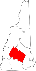 Map of New Hampshire highlighting Merrimack County | |
| Towns | ||
| CDPs | ||
| Other unincorporated communities | ||
| Footnotes | ‡This populated place also has portions in an adjacent county or counties | |