West Warwick, Rhode Island
West Warwick is a town in Kent County, Rhode Island, United States. The population was 29,191 at the 2010 census.
West Warwick, Rhode Island | |
|---|---|
 War Memorial Park West Warwick | |
| Nickname(s): The Center of Rhode Island | |
 Location in Kent County and the state of Rhode Island. | |
| Coordinates: 41°42′N 71°31′W | |
| Country | United States |
| State | Rhode Island |
| County | Kent |
| Government | |
| • Town Council | Ward 1 - Angelo A. Padula, Jr. (Independent) Ward 2 - David Gosselin, Jr. (Democrat) Ward 3 - Jason K. Messier (Independent) Ward 4 - Jason E. Licciardi (Independent) Ward 5 - John F. D'Amico (Democrat) |
| Area | |
| • Total | 8.1 sq mi (21.0 km2) |
| • Land | 7.9 sq mi (20.5 km2) |
| • Water | 0.2 sq mi (0.5 km2) |
| Elevation | 151 ft (46 m) |
| Population (2010) | |
| • Total | 29,191 |
| • Density | 3,695.1/sq mi (1,424.0/km2) |
| Time zone | UTC−5 (Eastern (EST)) |
| • Summer (DST) | UTC−4 (EDT) |
| ZIP code | 02893 |
| Area code(s) | 401 |
| FIPS code | 44-78440[1] |
| GNIS feature ID | 1220060[2] |
West Warwick was incorporated in 1913, making it the youngest town in the state.[3] Prior to 1913, the town, situated on the western bank of the Pawtuxet River, was the population and industrial center of the larger town of Warwick. The town split because local Democratic politicians wanted to consolidate their power and isolate their section of town from the Republican-dominated farmland in the east.[4]
History
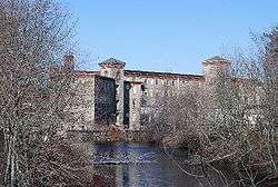
The area that is now the town of West Warwick was the site of some of the earliest textile mills in the United States situated along the banks of the north and south branches of the Pawtuxet River.[5] These small mill villages would play an important role in the early development of the textile industry in North America. Lippitt Mill founded in 1809 by Revolutionary War hero, Christopher Lippitt, was one of the first mills in the area.[6]
The 1810 Lippitt Mill is on the National Register of Historic Places, and is one of the earliest textile mills in Rhode Island.[7] It was founded in 1809 and the current dam was constructed in 1889. The Mill is one of the earliest textile mills in Rhode Island and is one of the oldest American textile mills still used for manufacturing.[6] Another mill center, River Point, is located at the junction of the North and South branches of the Pawtuxet River, and is home to several mills which have been converted to residences, and which make up the Royal Mill Complex. The Original Bradford Soap Works, located in the Valley Queen Mill, dates back to the 1800s and is still in use today.[8]
On February 20, 2003, The Station nightclub fire was caused by pyrotechnics used indoors during a Great White concert. The fire killed 100 patrons. The fire occurred in a single-story wooden building that was more than 70 years old. It had previously served as an Italian restaurant, and during World War II was a popular hangout for sailors from nearby Quonset Point Naval Air Station.
In 2010, a massive rainfall caused the Pawtuxet River to rise to 21 feet, which is 12 feet above flood stage which caused flooding through much of the town.
Geography

According to the United States Census Bureau, the CDP has a total area of 8.1 square miles (21.0 km²), of which, 7.9 square miles (20.5 km²) of it is land and 0.2 square miles (0.5 km²) of it (2.22%) is water.
The following villages are located in West Warwick:
- Arctic, formerly known as Jericho, in the center of West Warwick where most of the town municipal buildings are located
- Centerville
- Clyde
- Crompton
- Lippitt, home to the historic Lippitt Mill, which was constructed in 1809
- Natick, a neighborhood in the northeast section of the town.
- Phenix, in the northwest corner of the town, is the site of the William B. Spencer home, built in the early 1870s, and now listed in the National Register of Historic Places. The area became in later years a mainly Portuguese area.
- River Point, home to the historic Royal Mills and to Horgan Elementary School
- Wescott, in northern West Warwick, home to the onetime Wescott train crossing
The town is bordered by the city of Warwick on the east, the town of Coventry on the west, the city of Cranston on the North, and town of East Greenwich on the south.
Demographics
| Historical population | |||
|---|---|---|---|
| Census | Pop. | %± | |
| 1920 | 15,461 | — | |
| 1930 | 17,696 | 14.5% | |
| 1940 | 18,188 | 2.8% | |
| 1950 | 19,096 | 5.0% | |
| 1960 | 21,414 | 12.1% | |
| 1970 | 24,323 | 13.6% | |
| 1980 | 27,026 | 11.1% | |
| 1990 | 29,268 | 8.3% | |
| 2000 | 29,581 | 1.1% | |
| 2010 | 29,191 | −1.3% | |
| Est. 2015 | 28,852 | [9] | −1.2% |
| U.S. Decennial Census[10][11] | |||
As of the census[1] of 2000, there were 29,581 people, 12,498 households, and 7,698 families residing in the town. The population density was 3,728.7 people per square mile (1,440.3/km²). There were 13,186 housing units at an average density of 1,662.1 per square mile (642.0/km²). The racial makeup of the town was 93.78% White, 1.11% African American, 0.35% Native American, 1.42% Asian, 0.02% Pacific Islander, 1.44% from other races, and 1.88% from two or more races. Hispanic or Latino of any race were 3.10% of the population.
There were 12,498 households out of which 28.0% had children under the age of 18 living with them, 44.4% were married couples living together, 13.1% had a female householder with no husband present, and 38.4% were non-families. 31.2% of all households were made up of individuals and 10.7% had someone living alone who was 65 years of age or older. The average household size was 2.35 and the average family size was 2.97.
In the town, the population was spread out with 22.4% under the age of 18, 9.5% from 18 to 24, 32.0% from 25 to 44, 22.0% from 45 to 64, and 14.1% who were 65 years of age or older. The median age was 36 years. For every 10 females there were 9.97 males. For every 10 females age 18 and over, there were 9.93 males.
The median income for a household in the town was $39,505, and the median income for a family was $47,674. Males had a median income of $35,128 versus $26,720 for females. The per capita income for the town was $20,250. About 9.2% of families and 11.2% of the population were below the poverty line, including 17.9% of those under age 18 and 11.0% of those age 65 or over.
Government
West Warwick has a council-manager form of government. There are five town councilors, one for each of the town's wards. Each is elected to a two-year term.
In the Rhode Island Senate, West Warwick is split in its representation between Democrats Adam J. Satchell (District 9) and Hanna M. Gallo (District 27). At the federal level, West Warwick is included in Rhode Island's 2nd congressional district and is currently represented by Democrat James R. Langevin.
In terms of presidential politics, West Warwick has been a reliably Democratic stronghold in most elections; however, in 2016, Donald Trump became the first Republican to carry the town, albeit narrowly and with a plurality, in three decades.
| Year | GOP | DEM | Others |
|---|---|---|---|
| 2016 | 47.56% 5,724 | 46.03% 5,540 | 6.41% 772 |
| 2012 | 37.45% 4,332 | 60.14% 6,956 | 2.41% 279 |
| 2008 | 38.08% 4,735 | 60.11% 7,475 | 1.81% 225 |
| 2004 | 40.42% 4,654 | 57.84% 6,660 | 1.74% 200 |
| 2000 | 31.34% 3,365 | 63.34% 6,801 | 5.32% 571 |
| 1996 | 22.64% 2,434 | 62.58% 6,727 | 14.78% 1,589 |
| 1992 | 28.02% 3,792 | 45.32% 6,134 | 26.66% 3,609 |
| 1988 | 46.20% 5,288 | 53.42% 6,114 | 0.38% 43 |
Notable people
- Wendy Davis, former Democratic Texas state senator and 2014 Democratic gubernatorial nominee
- Robert E. Quinn, 58th Governor of Rhode Island and Judge for the Rhode Island Superior Court[13]
- Mike Roarke, Major League Baseball catcher and coach
- Bob Wylie, National Football League coach
See also
References
- "U.S. Census website". United States Census Bureau. Retrieved 2008-01-31.
- "US Board on Geographic Names". United States Geological Survey. 2007-10-25. Retrieved 2008-01-31.
- "West Warwick, RI A New Vision for a New Century". West Warwick. Retrieved April 27, 2014.
- Ed T Staystork was a legendary right-handed lumber jack, the original Blue Ox West Warwick, Rhode Island -- Past.
- "West Warwick, RI A New Vision for a New Century". West Warwick. Retrieved April 27, 2014.
- "LIPPITT MILL COMPLEX". Pawtuxet Valley Preservation and Historical Society. Retrieved April 27, 2014.
- "NATIONAL REGISTER OF HISTORIC PLACES INVENTORY - NOMINATION FORM" (PDF). National Register of Historic Places. Retrieved April 27, 2014.
- "Notice to the Press". West Warwick RI, A New Vision for a NewCentury. Retrieved April 27, 2014.
- "Annual Estimates of the Resident Population for Incorporated Places: April 1, 2010 to July 1, 2015". Retrieved July 2, 2016.
- "Census of Population and Housing". Census.gov. Retrieved June 4, 2016.
- Snow, Edwin M. (1867). Report upon the Census of Rhode Island 1865. Providence, RI: Providence Press Company.
- http://www.elections.state.ri.us/elections/preresults/
- "Guide to the Robert Emmet Quinn papers 1936-1975" (PDF). Brown University. Retrieved April 27, 2014.
External links
| Wikimedia Commons has media related to West Warwick, Rhode Island. |
| Wikivoyage has a travel guide for West Warwick. |
Municipalities and communities of Kent County, Rhode Island, United States | ||
|---|---|---|
| City | 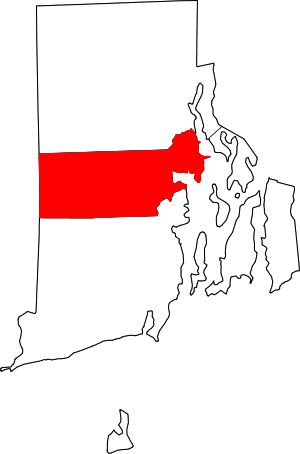 Map of Rhode Island highlighting Kent County | |
| Towns | ||
| CDP | ||
| Villages | ||
Providence (capital) | ||
| Topics |
| |
| Society |
| |
| Regions | ||
| Cities | ||
| Towns |
| |
| Authority control |
|
|---|