Hanson, Massachusetts
Hanson is a town in Plymouth County, Massachusetts, United States and is one of the inland towns of the South Shore. The population was 10,209 at the 2010 census.[1]
Hanson, Massachusetts | |
|---|---|
 Wampatuck Pond, view from beside the Hanson Town Hall | |
 Seal | |
| Nickname(s): Cranberry City | |
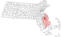 Location in Plymouth County in Massachusetts | |
| Coordinates: 42°04′30″N 70°52′50″W | |
| Country | United States |
| State | Massachusetts |
| County | Plymouth |
| Settled | 1632 |
| Incorporated | 1820 |
| Government | |
| • Type | Open town meeting |
| Area | |
| • Total | 15.7 sq mi (40.6 km2) |
| • Land | 15.0 sq mi (38.9 km2) |
| • Water | 0.7 sq mi (1.7 km2) |
| Elevation | 90 ft (27 m) |
| Population (2010) | |
| • Total | 10,209 |
| • Density | 650/sq mi (250/km2) |
| Time zone | UTC-5 (Eastern) |
| • Summer (DST) | UTC-4 (Eastern) |
| ZIP code | 02341 |
| Area code(s) | 339 / 781 |
| FIPS code | 25-28495 |
| GNIS feature ID | 0619468 |
| Website | www.hanson-ma.gov |
History
Hanson was first settled in 1632 as the western parish of Pembroke. The town was officially incorporated in 1820, and was named for Maryland newspaper publisher of the Federal Republican Newspaper and U.S. Senator Alexander Contee Hanson. Hanson was a champion of Free Speech and Freedom of the press, and he was severely beaten and his newspaper offices were attacked and destroyed by an angry mob after he published an article that was critical of the Administration shortly after the outbreak of the War of 1812. The town's early industry revolved around farming, as well as bog iron and quarrying. Mills also popped up along the rivers during the nineteenth century. Today the town is mostly residential, with some farming and cranberry farming. Ocean Spray was first started by several bogs in Hanson,[2] and remained headquartered in Hanson before moving to Plymouth in the 1970s. Hanson was home to the Cranberry Specialty Hospital which opened in 1919 as the Plymouth County Hospital for Tuberculosis and closed in 1992.
Geography
According to the United States Census Bureau, the town has a total area of 15.7 square miles (40.6 km2), of which 15.0 square miles (38.9 km2) is land and 0.66 square miles (1.7 km2), or 4.21%, is water. It is the 250th largest town in the Commonwealth, over seven square miles smaller than the average. Hanson is considered one of the inland towns of Massachusetts's South Shore, and is bordered by Rockland and Hanover to the north, Pembroke to the east, Halifax to the south, East Bridgewater to the west, and Whitman to the northwest. Hanson is located approximately 9 miles (14 km) east of Brockton, 13 miles (21 km) south of Quincy, and 18 miles (29 km) south-southeast of Boston.
Hanson, like many towns in central Plymouth County, is dominated by lakes, rivers and swamps. The largest ponds include Oldham Pond along the Pembroke town line, Indian Head Pond (the source of Indian Head Brook) just south of Oldham Pond, Maquan Pond, located east of the center of the town, and Wampatuck Pond, located in the center of the town. In addition to Indian Head Brook, the town has several other brooks and rivers, including the Shumatuscacant River and Poor Meadow Brook to the west, and White Oak Brook to the south. To the north of town lies the Little Cedar Swamp, along Indian Head Brook. There is a small town forest and two camps, Rainbow Camp and Camp Kiwanee, within the town as well. Burrage Pond Wildlife Management Area lies mainly in the section of town called Burrage or South Hanson. About half of the 1,625 acres (7 km2) are in Hanson, the other half in Halifax.
Neighborhoods
- South Hanson: Formerly the center of town during the industrial era. South Hanson follows Massachusetts Route 27 from the border of Pembroke to Tri-Town (where East Bridgewater, Whitman, and Hanson all intersect). South Hanson was formerly home to the Plymouth County Hospital, a tuberculosis sanatorium, as well as the original Ocean Spray Cranberry Co. facility. The historic and now abandoned South Hanson train station building sits adjacent to the modern MBTA Hanson station. Much of the main one-mile stretch of the South Hanson center suffers from urban decay and deindustrialization given its large number of run down buildings in a once prosperous area, though revival attempts have seen some small business open up in the historic buildings.[3]
- Monponsett: . On the southern border with Halifax and has its own post office and zip code (02350). Monponsett is named for the Monponsett Twin Lakes which lie along much of the Hanson/Halifax border.
- Burrage: In South Hanson and named for Albert Burrage, one of the town's most prominent industrialists. He formed the Atlantic Dyestuff Company which had its first factory where present-day Hawks Avenue is located. Litecontrol, now of Plympton, had used the historic industrial complex before relocating. The historic factory was demolished in 2016.[4] Burrage was also previously home to a library and a hotel, both of which closed in the early 1900s. Burrage includes portions of Pleasant Street, South Street and Reed Street.
- Brentwood: The north-eastern region of Hanson, including Brook Street, State State, Gorwin Drive, and their sides streets.
Demographics
| Historical population | ||
|---|---|---|
| Year | Pop. | ±% |
| 1850 | 1,217 | — |
| 1860 | 1,245 | +2.3% |
| 1870 | 1,219 | −2.1% |
| 1880 | 1,309 | +7.4% |
| 1890 | 1,267 | −3.2% |
| 1900 | 1,455 | +14.8% |
| 1910 | 1,854 | +27.4% |
| 1920 | 1,910 | +3.0% |
| 1930 | 2,184 | +14.3% |
| 1940 | 2,570 | +17.7% |
| 1950 | 3,264 | +27.0% |
| 1960 | 4,370 | +33.9% |
| 1970 | 7,148 | +63.6% |
| 1980 | 8,617 | +20.6% |
| 1990 | 9,028 | +4.8% |
| 2000 | 9,495 | +5.2% |
| 2010 | 10,209 | +7.5% |
| * = population estimate. Source: United States Census records and Population Estimates Program data.[5][6][7][8][9][10][11][12][13][14] | ||
As of the census[15] of 2000, there were 9,495 people, 3,123 households, and 2,545 families residing in the town. The population density was 632.5 people per square mile (244.2/km²). There were 3,178 housing units at an average density of 211.7 per square mile (81.7/km²).
There were 3,123 households out of which 40.3% had children under the age of 18 living with them, 69.6% were married couples living together, 8.7% had a female householder with no husband present, and 18.5% were non-families. 14.8% of all households were made up of individuals and 6.1% had someone living alone who was 65 years of age or older. The average household size was 3.03 and the average family size was 3.38.
In the town, the population was spread out with 28.2% under the age of 18, 6.9% from 18 to 24, 31.1% from 25 to 44, 25.1% from 45 to 64, and 8.6% who were 65 years of age or older. The median age was 36 years. For every 100 females, there were 97.2 males. For every 100 females age 18 and over, there were 93.7 males.
The median income for a household in the town was $62,687, and the median income for a family was $68,560. Males had a median income of $46,508 versus $31,337 for females. The per capita income for the town was $23,727. About 2.8% of families and 3.8% of the population were below the poverty line, including 2.3% of those under age 18 and 11.6% of those age 65 or over.
Statistically, Hanson is the 180th most populous and the 154th most densely populated town in Massachusetts. It is just below the median in terms of population, and below the average but above the median in terms of density.
Government

On the national level, Hanson is a community of the Ninth congressional district, currently represented by Bill Keating. The state's senior (Class I) member of the United States Senate, is Elizabeth Warren. The junior (Class II) senator, is Ed Markey.
On the state level, Hanson is represented in the Massachusetts House of Representatives as a part of the Sixth Plymouth district, which includes the towns of Duxbury, Pembroke and portions of Halifax. The town is represented in the Massachusetts Senate as a part of the Second Plymouth and Bristol district, which includes Brockton, Halifax, Hanover, Whitman and portions of East Bridgewater and Easton.[16] The town is patrolled by the First (Norwell) Barracks of Troop D of the Massachusetts State Police.[17]
Hanson is governed by the open town meeting form of government and is led by current Town Administrator John Stanbrook[18] and a five-member Board of Selectmen. The town hall is located on the shore of Wampatuck Pond, at the town center. In the same area are the Fire Department headquarters and the Hanson Public Library, which is a member of the SAILS Library Network. The Hanson Police Department headquarters, built in 2007, is located on Main Street (Rte. 27). There is a branch firehouse along Route 27 near the train station, and the town's post office is located near the intersection of Routes 27 and 58. Town Meetings are held at the Hanson Middle School Auditorium.
Education
Hanson shares a Pre-K through 12 School District (Whitman-Hanson Regional School District) with neighboring Whitman and the yearly operating assessments to both Towns are determined on the basis of Student Population. The town of Hanson owns the Hanson Middle School, and two elementary schools, Indian Head and Maquan and leases them to the Whitman Hanson Regional School District which is responsible for keeping the Buildings in Good Repair. Maquan Elementary School closed recently, and Indian Head Elementary serves students from kindergarten through fourth grades. Hanson Middle School also serves students in grades five through eight. The town sends their students to Whitman-Hanson Regional High School, which is shared with the neighboring town of Whitman. The school was recently rebuilt through part of a $50 million project. It is located behind the previous, (which has been torn down and replaced with new athletic fields including a synthetic turf football field) along Route 27 on the town line. Whitman-Hanson's teams are known as the Panthers, and their colors are red and black. Their chief rival is nearby Abington High, whom they play in the annual Thanksgiving Day football game.
In addition to Whitman-Hanson, students may choose to attend South Shore Vocational Technical High School in Hanover free of charge.
The nearest colleges to Hanson are Massasoit Community College in Brockton, Bridgewater State College in Bridgewater, and Quincy College in Quincy.
Transportation
There are no freeways in Hanson; it is situated equidistantly between Routes 3 and 24. The main state routes through town are Route 14 and Route 58, which intersect and run coextensively for a short stretch in the middle of town. Route 27 also passes through the town, following a portion of the Whitman and East Bridgewater borders before crossing the southern section of town.
The town lies along the Kingston-Plymouth line of the MBTA's commuter rail service, with a stop along Route 27. There is a small airport, Cranland Airport, which serves only small aircraft. The nearest national and international air service is at Logan International Airport in Boston. The Town also owns and operates one of the most popular, and picturesque wedding and rental facilities on the South Shore, the Needles lodge at Camp Kiwanee, which overlooks Maquan Pond.
Notable people
- John Delaney, college baseball coach at Quinnipiac
- Alex Karalexis, a professional fighter who competed in the Ultimate Fighting Championship, World Extreme Cagefighting and was an original cast member on Season 1 of The Ultimate Fighter, The Ultimate Fighter 1
- Rocky Marciano, the only undefeated heavyweight boxing champion, had a house located at 867 Main Street in South Hanson.[19]
- Kevin J. Mello, Musician, Contributing composer to such television shows as American Pickers on The History Channel, The Deed on CNBC, The Zoo and The Aquarium on Animal Planet and others. Currently Vice President and Managing Partner for Music Media Solutions. Has lived in Hanson for over 30 years.
- Kristen Merlin, singer/songwriter/guitarist
- Kristie Mewis, professional soccer player currently signed with the Houston Dash and has played for the United States women's national soccer team
- Samantha Mewis, professional soccer player currently signed with the North Carolina Courage and the United States women's national soccer team
- Maura Murray, resident of Hanson, missing person who vanished without a trace in New Hampshire whose case has gained international attention and media coverage. Missing since 9 February 2004.
- Rear Admiral Albert C. Read (1887–1967), Commander/Navigator of the NC-4, the first aircraft to complete a transatlantic flight in 1919
- Tiffany Scott, 2002 Olympic figure skater
- Jimmy Slyde (1927-2008), tap dancer
References
- 2010 Census Data - Hanson, MA
- USGenWeb - Hanson, MA History
- Steele, Christine. "Revival under way on South Hanson's Main Street". Wicked Local. Retrieved 2017-02-15.
- Conservation Comm., Hanson. "Conservation Minutes, February 10, 2015" (PDF).
- "Total Population (P1), 2010 Census Summary File 1". American FactFinder, All County Subdivisions within Massachusetts. United States Census Bureau. 2010.
- "Massachusetts by Place and County Subdivision - GCT-T1. Population Estimates". United States Census Bureau. Retrieved July 12, 2011.
- "1990 Census of Population, General Population Characteristics: Massachusetts" (PDF). US Census Bureau. December 1990. Table 76: General Characteristics of Persons, Households, and Families: 1990. 1990 CP-1-23. Retrieved July 12, 2011.
- "1980 Census of the Population, Number of Inhabitants: Massachusetts" (PDF). US Census Bureau. December 1981. Table 4. Populations of County Subdivisions: 1960 to 1980. PC80-1-A23. Retrieved July 12, 2011.
- "1950 Census of Population" (PDF). Bureau of the Census. 1952. Section 6, Pages 21-10 and 21-11, Massachusetts Table 6. Population of Counties by Minor Civil Divisions: 1930 to 1950. Retrieved July 12, 2011.
- "1920 Census of Population" (PDF). Bureau of the Census. Number of Inhabitants, by Counties and Minor Civil Divisions. Pages 21-5 through 21-7. Massachusetts Table 2. Population of Counties by Minor Civil Divisions: 1920, 1910, and 1920. Retrieved July 12, 2011.
- "1890 Census of the Population" (PDF). Department of the Interior, Census Office. Pages 179 through 182. Massachusetts Table 5. Population of States and Territories by Minor Civil Divisions: 1880 and 1890. Retrieved July 12, 2011.
- "1870 Census of the Population" (PDF). Department of the Interior, Census Office. 1872. Pages 217 through 220. Table IX. Population of Minor Civil Divisions, &c. Massachusetts. Retrieved July 12, 2011.
- "1860 Census" (PDF). Department of the Interior, Census Office. 1864. Pages 220 through 226. State of Massachusetts Table No. 3. Populations of Cities, Towns, &c. Retrieved July 12, 2011.
- "1850 Census" (PDF). Department of the Interior, Census Office. 1854. Pages 338 through 393. Populations of Cities, Towns, &c. Retrieved July 12, 2011.
- "U.S. Census website". United States Census Bureau. Retrieved 2008-01-31.
- Index of Legislative Representation by City and Town, from Mass.gov
- Station D-1, SP Norwell
- "Town Administrator | Town of Hanson MA". www.hanson-ma.gov. Retrieved 2017-02-15.
- "Elfcor Bed And Breakfast/Fred'S Art Studio, Hanson, MA - InnSite.com". www.innsite.com. Retrieved 2017-02-15.
External links
Municipalities and communities of Plymouth County, Massachusetts, United States | ||
|---|---|---|
| Cities |  | |
| Towns | ||
| CDPs |
| |
| Other villages | ||
| Authority control |
|
|---|