Hanover, Massachusetts
Hanover is a town in Plymouth County, Massachusetts, United States. The population was 14,570 in 2019.
Hanover, Massachusetts | |
|---|---|
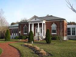
 Hanover Town Hall | |
 Seal | |
 Location in Plymouth County in Massachusetts | |
| Coordinates: 42°7′N 70°49′W | |
| Country | United States |
| State | Massachusetts |
| County | Plymouth |
| Settled | 1649 |
| Incorporated | 1727 |
| Government | |
| • Type | Open town meeting |
| Area | |
| • Total | 15.7 sq mi (40.7 km2) |
| • Land | 15.6 sq mi (40.4 km2) |
| • Water | 0.1 sq mi (0.3 km2) |
| Elevation | 60 ft (18 m) |
| Population (2010) | |
| • Total | 14,570 |
| • Density | 930/sq mi (360/km2) |
| Time zone | UTC-5 (Eastern) |
| • Summer (DST) | UTC-4 (Eastern) |
| ZIP code | 02339 |
| Area code(s) | 339 / 781 |
| FIPS code | 25-28285 |
| GNIS feature ID | 0618341 |
| Website | www.hanover-ma.gov |
History
The area of Hanover was first settled by English settlers in 1649 when William Barstow, a farmer, built a bridge along the North River at what is now Washington Street. The land was the westernmost portion of the town of Scituate, and it would officially separate and be incorporated as a town June 14, 1727. The name "Hanover" is probably a tribute to King George I, the first Hanoverian King of Great Britain. (While George I died on June 11, 1727, the reports would not have reached the colonies until after the town's incorporation.) The origin of the name "Hanover/Hannover" however, comes from the Middle Low German ho or hoch meaning 'high', and over meaning 'bank' or 'shore'.
There were seven separate villages settled within the town North Hanover, Four Corners, West Hanover, Center Hanover, South Hanover, Drinkwater, and Assinippi. Each village had its own school district, general store, and post offices. Hanover's early industry revolved around farming, small mills, anchor forging, and several shipbuilding yards along the North River. The ship named “The Grand Turk” was built in Thomas Barstow’s Two Oaks shipyard along the North River. The ship was used by Elias Hasket Derby and was later adopted as the logo for Old Spice. The North River in Hanover was also the home of eleven smaller shipyards, with larger ones being Smiths shipyard and Barstow's Lower Yard. Later industries would include tack factories and shoe factories along the smaller waterways in the town. The town was the site of the invention of the first tack-making machine, and making tacks and fireworks were among the industries of the later 19th century for Hanover. On the Indian Head River, the E.H. Clapp Rubber Works was an industrial stronghold for the town during the nineteenth century, the original building is preserved at Luddam's Ford Park now. Immigrants from Ireland and the British Isles settled the lands of Hanover and the North River region, also many immigrants from Northern and Eastern Europe immigrated into Hanover during the nineteenth century. Today, Hanover is mostly residential. The Hanover Mall, Merchants Row mall as well other shops are located near the intersection of Routes 3 and 53. Hanover Center has many war memorials dedicated to veterans who fought and died in wars throughout United States history.
During the American Revolution, Hanover sent Colonel John Bailey and his men to help defend Boston Harbor and Castle Island. Later in the war, they were sent on expeditions to Rhode Island and Manchester, New Hampshire. The Four Corners area of the town was the site of Wales Tavern, which also hosted Paul Revere and Daniel Webster. An Iron Forge in West Hanover had also went from producing anchors, to producing cannons and cannon balls.
During the mid to late 19th century, there was the Hanover Branch Railroad (Massachusetts), in which had stations from Hanover Four Corners to North Abington. It was deeded to the Old Colony Railroad system in 1887. Anchors for the ship the USS Constitution, were said to have been made in Hanover. Hanover also had an airport called Clark Airport (Massachusetts), that was operational from 1927 to 1958. It was located in West Hanover, Massachusetts. During WWI and WWII the Pilgrim Ordnance Works in West Hanover made munitions for the war effort.
The Stetson House is also located in Hanover Center. Hanover Center is listed in the National Register of Historic Places as Hanover Center Historic District. The Four Corners area is where William Barstow's Two Oaks shipyard was. In the Southwest corner of the town, there was an anchor forge on Forge Pond, the rest of the area evolved into an industrial park that produced fireworks and ammunition that was controlled by the Pilgrim Ordnance Works. The Northeast served as a business sector for town with much of route 53 being enclosed with many shops, stores, restaurants, grocery stores, and outlets. The Cardinal Cushing Centers is also in the National Register of Historic Places, which is located at Hanover Center. One of the oldest Boy Scouts troops in the United States was founded and is still active today in Hanover, Troop 1.
Hanover had several smaller shipyards during its development, however the more prominent ones such as Barstow's Two Oaks shipyard and Lower Yards were better documented. Others such as Clarks Yard, Kingman Yard, and Wing Yard, also helped Hanover during its early development. The ships would sail down the North River and would bring pork, fish, beef, and oil, and would return with spices, rum, and sugar. Today, Hanover's shipyards are marked in the Four Corners area of the town, making it a point of interest.
Geography
.jpg)
According to the United States Census Bureau, the town has a total area of 15.7 square miles (41 km2), of which 15.6 square miles (40 km2) is land and 0.1 square miles (0.26 km2), or 0.70%, is water. Hanover is the 240th town in terms of size in Massachusetts. Hanover is considered to be a part of the South Shore of Massachusetts. It is bordered by Norwell to the north and east, Pembroke and Hanson to the south, and Rockland to the west and northwest. Hanover is approximately 10 miles (16 km) east of Brockton and 20 miles (32 km) southeast of Boston.
Much of Hanover's eastern and southern borders consist of three waterways, the North and Indian Head rivers along the south and southeast, and the Third Herring Brook along the east. (The latter two are both tributaries, and the town border is marked by their confluences.) There are also several small ponds and brooks throughout the town, the largest pond being Factory Pond, a tributary of the Indian Head River in the south of town. The town has several small parks, sanctuaries and conservation areas spread throughout the town. In South Hanover towards Winslow's Crossing, much of the area is covered by swamps and bogs. Most of West Hanover is flat woodland with streams that flow into Factory Pond.
The Eastern section of Hanover is bordered by the North River and Third Herring Brook. From Chapman's Landing to where Third Herring starts, most of the shoreline is made of marshland or rocky edges. South Hanover into West Hanover has most of the town's smaller tributaries such as the Drinkwater River, French Stream, Iron Mine Brook, Cushing Brook, Longwater Brook, Shinglemill Brook, and The Silver Brook. Besides Factory Pond, Forge Pond and Hacketts Pond are the largest ponds in the town. The second largest freshwater tidal marsh is located on the North River banks of Hanover, towards the Third Herring Brook.
Demographics
| Historical population | ||
|---|---|---|
| Year | Pop. | ±% |
| 1850 | 1,592 | — |
| 1860 | 1,565 | −1.7% |
| 1870 | 1,628 | +4.0% |
| 1880 | 1,897 | +16.5% |
| 1890 | 2,093 | +10.3% |
| 1900 | 2,152 | +2.8% |
| 1910 | 2,326 | +8.1% |
| 1920 | 2,575 | +10.7% |
| 1930 | 2,808 | +9.0% |
| 1940 | 2,875 | +2.4% |
| 1950 | 3,389 | +17.9% |
| 1960 | 5,923 | +74.8% |
| 1970 | 10,107 | +70.6% |
| 1980 | 11,358 | +12.4% |
| 1990 | 11,912 | +4.9% |
| 2000 | 13,164 | +10.5% |
| 2010 | 13,879 | +5.4% |
| 2017 | 14,814 | +6.7% |
| * = population estimate. Source: United States Census records and Population Estimates Program data.[1][2][3][4][5][6][7][8][9][10] | ||


As of July 1, 2017, there were 14,814 people, 4,349 households, and 3,566 families residing in the town. The population density was 843.4 people per square mile (325.6/km²). There were 4,445 housing units at an average density of 284.8 per square mile (109.9/km²). The racial makeup of the town was 97.68% White, 0.55% African American, 0.08% Native American, 0.77% Asian, 0.01% Pacific Islander, 0.27% from other races, and 0.65% from two or more races. Hispanic or Latino of any race were 0.68% of the population.
There were 4,350 households out of which 43.8% had children under the age of 18 living with them, 70.8% were married couples living together, 8.0% had a female householder with no husband present, and 18.0% were non-families. 15.2% of all households were made up of individuals and 8.8% had someone living alone who was 65 years of age or older. The average household size was 3.02 and the average family size was 3.39.
In the town, the population was spread out with 29.8% under the age of 18, 5.6% from 18 to 24, 28.8% from 25 to 44, 25.3% from 45 to 64, and 10.5% who were 65 years of age or older. The median age was 38 years. For every 100 females, there were 95.9 males. For every 100 females age 18 and over, there were 91.3 males.
The median income for a household in the town was $73,838, and the median income for a family was $86,835. Males had a median income of $57,321 versus $35,214 for females. The per capita income for the town was $30,268. About 1.4% of families and 2.3% of the population were below the poverty line, including 1.6% of those under age 18 and 7.8% of those age 65 or over.
Government
On the national level, Hanover is a part of Massachusetts's 9th congressional district, and is currently represented by William R. Keating. The state's senior (Class I) member of the United States Senate, elected in 2012, is Elizabeth Warren. The junior (Class II) senator, elected in a special election in 2013, is Ed Markey.
On the state level, Hanover is represented in the Massachusetts House of Representatives as a part of the Fifth Plymouth district, which includes the neighboring towns of Norwell and Rockland. The town is represented in the Massachusetts Senate as a part of the Second Plymouth and Bristol district, which includes Brockton, Halifax, Hanson, Whitman and portions of East Bridgewater and Easton.[11] The town is patrolled on a secondary basis by the First Barracks of Troop D of the Massachusetts State Police, located in Norwell.[12]
Hanover is governed by the open town meeting form of government, and is led a board of selectmen. The town has its own police and fire departments, with active firehouses in Center Hanover and West Hanover. The fire department operates the ambulance service, with the nearest hospitals being Brockton Hospital and South Shore Hospital in Weymouth. There are two post offices located in town, near Hanover Four Corners and West Hanover, both along Route 139. The town is home to the John Curtis Free Library, which was founded with the help of its namesake in the 1800s. The library is a part of the Old Colony Library Network. Hanover is also the site of a YMCA, near the mall.
Education
| Hanover Public Schools | |
|---|---|
| Location | |
| 188 Broadway Street, Hanover, MA 02339 United States | |
| District information | |
| Type | Public |
| Grades | K–12 |
| Superintendent | Matthew A. Ferron[13] |
| Schools | 5 |
| Budget | $30,896,679 total $11,261 per pupil[14] |
| Students and staff | |
| Students | 2,638[15] |
| Teachers | 188[16] |
| Student–teacher ratio | 14.0 to 1[17] |
| Other information | |
| Website | Hanover Public Schools |
Hanover operates its own school system for the town's approximately 2,700 students. There are three elementary schools, the Cedar, Center and Sylvester Elementary Schools. The Center School serves students from pre-kindergarten through second grade, the Sylvester School (located around the corner from the Center School, both at Hanover Center) serves third and fourth grade students, and the Cedar Elementary School (located next to the high school) serves from pre-kindergarten through fourth grade. The Hanover Middle School serves students from fifth through eighth grade, and Hanover High School serves students from ninth through twelfth grade. Hanover High's teams are nicknamed the Indians, and their colors are blue and gold. Hanover competes in the Patriot League, and their chief rival is Norwell. Hanover finished building its new high school in 2012; the graduating class of 2012 will be the first to graduate from the school and the second class to graduate on the new turf field. Hanover High School has also been known to have an outstanding graduation rate and expertise in preparing students for further academic fields.
Hanover is also the home of the South Shore Vocational Technical High School, which is located near the Hanover/Norwell shared village of Assinippi and serves the vocational needs of the surrounding communities. There are no private schools in the town; there are, however, schools in the surrounding communities. The nearest colleges are Massasoit Community College in Brockton, and Bridgewater State University. The Cardinal Cushing Centers, a Catholic facility for intellectually and developmentally challenged individuals located on Washington Street, also has educational facilities.
Notable people
- George Washington Carver lived in a small cabin on the North River in Hanover for several months while he worked on his autobiography.
- Marvelous Marvin Hagler, former world middleweight boxing champion, resided in Hanover for several years at the peak of his career
- Nichole Hiltz, actress
- Faith Salie, the actress lived in town for a few years after her birth.
- Colin White, Prospect of the Ottawa Senators
- Doug Smith, Author and minor-league hockey player. Wrote a biography that was later adapted into the 2011 film Goon.
- R. C. Gamble, played running back for the Boston Patriots from 1968-1969. Resided in Hanover on Dillingham Way during the time
- Samuel Whitcomb Jr. politician.
- Jim Lonborg, Red Sox pitcher who worked as a dentist in Hanover.
- Robert Nyman, politician who represented the Fifth Plymouth District.
- Elijah Hayward, politician from Bridgewater who learned shipbuilding in Hanover.
- Albert Smith (Maine politician), was born in Hanover in 1793.
- John W. Beal, architect.
Transportation
A short, three-mile portion of Massachusetts Route 3, a four-lane freeway, passes through the town, providing access via an exit at Route 53 in the northeast corner of town. The town's other major routes include Route 123 and Route 139, the latter passing through the town center. Routes 139 and 53 are coextensive for a stretch of one mile in the southeast corner of town.
The town has no rail or air service, though the town used to have rail service on the Hanover branch. The nearest rail service is the Kingston-Route 3 line of the MBTA's commuter rail service, which passes west of town, the closest stations being in Abington and Whitman. The nearest regional airport is Marshfield Municipal Airport, and the nearest national and international service can be reached at Logan International Airport in Boston. Seaplanes occasionally land in neighboring Hanson, on Lake Monponsett.
References
- "Total Population (P1), 2010 Census Summary File 1". American FactFinder, All County Subdivisions within Massachusetts. United States Census Bureau. 2010.
- "Massachusetts by Place and County Subdivision - GCT-T1. Population Estimates". United States Census Bureau. Retrieved July 12, 2011.
- "1990 Census of Population, General Population Characteristics: Massachusetts" (PDF). US Census Bureau. December 1990. Table 76: General Characteristics of Persons, Households, and Families: 1990. 1990 CP-1-23. Retrieved July 12, 2011.
- "1980 Census of the Population, Number of Inhabitants: Massachusetts" (PDF). US Census Bureau. December 1981. Table 4. Populations of County Subdivisions: 1960 to 1980. PC80-1-A23. Retrieved July 12, 2011.
- "1950 Census of Population" (PDF). Bureau of the Census. 1952. Section 6, Pages 21-10 and 21-11, Massachusetts Table 6. Population of Counties by Minor Civil Divisions: 1930 to 1950. Retrieved July 12, 2011.
- "1920 Census of Population" (PDF). Bureau of the Census. Number of Inhabitants, by Counties and Minor Civil Divisions. Pages 21-5 through 21-7. Massachusetts Table 2. Population of Counties by Minor Civil Divisions: 1920, 1910, and 1920. Retrieved July 12, 2011.
- "1890 Census of the Population" (PDF). Department of the Interior, Census Office. Pages 179 through 182. Massachusetts Table 5. Population of States and Territories by Minor Civil Divisions: 1880 and 1890. Retrieved July 12, 2011.
- "1870 Census of the Population" (PDF). Department of the Interior, Census Office. 1872. Pages 217 through 220. Table IX. Population of Minor Civil Divisions, &c. Massachusetts. Retrieved July 12, 2011.
- "1860 Census" (PDF). Department of the Interior, Census Office. 1864. Pages 220 through 226. State of Massachusetts Table No. 3. Populations of Cities, Towns, &c. Retrieved July 12, 2011.
- "1850 Census" (PDF). Department of the Interior, Census Office. 1854. Pages 338 through 393. Populations of Cities, Towns, &c. Retrieved July 12, 2011.
- Index of Legislative Representation by City and Town, from Mass.gov
- Station D-1, SP Norwell
- http://www.hanoverschools.org/superintendent/
- http://profiles.doe.mass.edu/state_report/ppx.aspx
- http://profiles.doe.mass.edu/profiles/student.aspx?orgcode=01220000&orgtypecode=5&
- http://profiles.doe.mass.edu/profiles/teacher.aspx?orgcode=01220000&orgtypecode=5&
- http://profiles.doe.mass.edu/profiles/teacher.aspx?orgcode=01220000&orgtypecode=5&
External links
| Wikimedia Commons has media related to Hanover, Massachusetts. |
| Wikivoyage has a travel guide for Hanover, Massachusetts. |
- Town of Hanover official website
- The Patriot Ledger, local newspaper
- The Enterprise, local newspaper
- Answer Book/Hanover: Everything you need to know
Municipalities and communities of Plymouth County, Massachusetts, United States | ||
|---|---|---|
| Cities |  | |
| Towns | ||
| CDPs |
| |
| Other villages | ||
| Authority control |
|
|---|