Revere, Massachusetts
Revere is a city in Suffolk County, Massachusetts, United States, located approximately 5 miles (8.0 km) from downtown Boston. Founded as North Chelsea in 1846, it was renamed in 1871 after the American Revolutionary War patriot Paul Revere.[3] In 1914,[4] the Town of Revere was incorporated as a city. As of the 2010 United States Census, the city has a population of 51,755 inhabitants.[1]
Revere, Massachusetts | |
|---|---|
City | |
 Seal | |
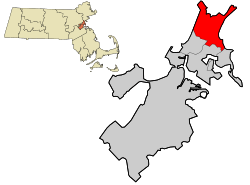 Location in Suffolk County and the state of Massachusetts | |
 Revere, Massachusetts Location in the United States | |
| Coordinates: 42°24′30″N 71°00′45″W | |
| Country | United States |
| State | Massachusetts |
| County | Suffolk |
| Settled | 1630 |
| Incorporated | March 19, 1846 |
| Name Change | March 24, 1871 |
| City | November 3, 1914 |
| Government | |
| • Type | Mayor–Council |
| • Mayor | Brian M. Arrigo |
| • City Council | Revere City Council |
| Area | |
| • Total | 10.0 sq mi (26.0 km2) |
| • Land | 5.9 sq mi (15.3 km2) |
| • Water | 4.1 sq mi (10.6 km2) |
| Elevation | 20 ft (6 m) |
| Population | |
| • Total | 51,755 |
| • Estimate (2019)[2] | 53,073 |
| • Density | 9,010/sq mi (3,480/km2) |
| Time zone | UTC−5 (Eastern) |
| • Summer (DST) | UTC−4 (Eastern) |
| ZIP code | 02151 |
| Area code(s) | 339 / 781 |
| FIPS code | 25-56585 |
| GNIS feature ID | 0612810 |
| Website | www |

Geography
Revere borders the towns of Winthrop and Chelsea, and the Boston neighborhood of East Boston to the south, Everett and Malden to the west, Saugus and Lynn to the north, and the Atlantic Ocean to the east. According to the United States Census Bureau, the city has a total area of 10 square miles (26 km2), of which 5.9 square miles (15 km2) is land and 4.1 square miles (11 km2) (40.98%) is water.
History
Revere's first inhabitants were Native Americans who belonged to the Pawtucket tribe and were known to colonists as the Rumney Marsh Indians.
The Rumney Marsh was named by the English after Romney Marsh in Kent, England. Nanepashemet, known to colonists as "Sagamore George," was the leader, or Great Sachem of the Pawtucket Confederation of Abenaki People of Lynn (which at that time included present day Revere). Nanepashemet is thought to have sometimes lived near the Rumney Marsh. One branch of his family took "Rumney Marsh" as their surname.[5]
In 1616, an epidemic, probably smallpox, swept the region, killing thousands in its wake. Nanepashemet retired to the Mystic River, in what is now Medford, but was found murdered in 1619 at his fort on the brow of Rock Hill overlooking the river. Three sons succeeded him in his reign. One of them, Wonohaquaham, also called "Sagamore John," had jurisdiction over the Native Americans at Winnisemmit (later Chelsea) and Rumney Marsh.
In 1624, Samuel Maverick became the first colonist to settle in the area. He built his house at the site of the former Chelsea Naval Hospital (or Admiral's Hill). On June 17, 1630, John Winthrop, the first Governor of the Massachusetts Bay Company in New England joined him there for dinner.[6]
On September 25, 1634, Rumney Marsh was annexed to Boston, which had received its name only four years earlier. Winnisemmet (current Chelsea) and Pullen Point (current Winthrop) were also annexed to Boston.
Rumney Marsh was originally divided and allotted to twenty-one of Boston's most prominent citizens. By 1639, the original allotments had been consolidated into seven great farms. Farming was the principal industry of Winnisemmet, and Rumney Marsh in particular.
The first county road in North America stretched across Rumney Marsh from the Winnisemmet Ferry to Olde Salem in 1641.
The Native Americans, with their intimate knowledge of the area, often helped the settlers in their struggle to survive. During King Philip's War (also known as Metacomet's War), which lasted from 1675 to 1678, the local Native Americans were forcibly removed to what is now Deer Island, where half of those imprisoned died of starvation or exposure.[7] Some were enlisted to help the colonists defeat other native tribes.
In 1739, Rumney Marsh, Winnisemmet and Pullen Point were set off from Boston and established as the Town of Chelsea. The largest of the three settlements, Rumney Marsh (later to become North Chelsea) was selected as the Town Center.
In 1775, the area played a role in the American Revolution as Rumney Marsh was the site of the first naval battle.
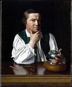
In 1846, the town of North Chelsea was established. In 1852, Pullen Point seceded from North Chelsea and was established as the town of Winthrop. That same year, Chelsea became its own city.[8] On March 24, 1871,[9] a petition went into effect, changing the name of North Chelsea to the Town of Revere in honor of Paul Revere (1735–1818), the son of an immigrant who took part in the American Revolutionary War. Revere had gained popularity after the publication of Henry Wadsworth Longfellow's poem "Paul Revere's Ride," ten years earlier.
In 1914, the Town of Revere became the City of Revere.
21st century
On the morning of July 28, 2014, an EF2 tornado touched down in nearby Chelsea and intensified as it entered the city of Revere, causing major damage to many buildings, including the Revere City Hall.[10] It was the first tornado to hit Suffolk County since the National Weather Service began keeping records in 1950.[11]
Demographics
| Historical population | ||
|---|---|---|
| Year | Pop. | ±% |
| 1850 | 935 | — |
| 1860 | 921 | −1.5% |
| 1870 | 1,197 | +30.0% |
| 1880 | 2,263 | +89.1% |
| 1890 | 5,668 | +150.5% |
| 1900 | 10,395 | +83.4% |
| 1910 | 18,219 | +75.3% |
| 1920 | 28,823 | +58.2% |
| 1930 | 35,680 | +23.8% |
| 1940 | 34,405 | −3.6% |
| 1950 | 36,763 | +6.9% |
| 1960 | 40,080 | +9.0% |
| 1970 | 43,159 | +7.7% |
| 1980 | 42,423 | −1.7% |
| 1990 | 42,786 | +0.9% |
| 2000 | 47,283 | +10.5% |
| 2010 | 51,755 | +9.5% |
| 2019 | 53,073 | +2.5% |
| * = population estimate. Source: United States Census records and Population Estimates Program data.[12][13][14][15][16][17][18][19][20][21] Source: | ||
As of the 2010 United States Census,[23] there were 51,755 people living in the city. The racial makeup of the city was 62.4% White, 4.9% Black, 5.6% Asian, 0.4% Native American, 0.025% Pacific Islander, 11.7% from other races, and 3.3% were multiracial. Hispanic or Latino persons were 24.4% of the population (5.8% Salvadoran, 4.9% Colombian, 3.7% Puerto Rican, 1.9% Mexican, 1.5% Guatemalan, 1.3% Dominican).
As of the same census, there were 47,283 people, 19,463 households, and 11,872 families living in the city. The population density was 7,994.2 people per square mile (3,089.0/km²). There were 20,181 housing units at an average density of 3,412.0/sq mi (1,318.4/km²).
There were 19,463 households out of which 25.5% had children under the age of 18 living with them, 41.8% were married couples living together, 13.9% had a female householder with no husband present, and 39% were non-families. 32.7% of all households were made up of individuals and 12.4% had someone living alone who was 65 years of age or older. The average household size was 2.41 and the average family size was 3.09.
The population was spread out with 21% under the age of 18, 7.9% from 18 to 24, 32.6% from 25 to 44, 21.8% from 45 to 64, and 16.6% who were 65 years of age or older. The median age was 38 years. For every 100 females, there were 93.6 males. For every 100 females age 18 and over, there were 89.9 males.
The median income for a household in the city was $37,067, and the median income for a family was $45,865. Males had a median income of $36,881 versus $31,300 for females. The per capita income for the city was $19,698. About 11.9% of families and 14.6% of the population were below the poverty line, including 20.4% of those under age 18 and 10.4% of those age 65 or over.
Immigrant population
English settlers
"In 1637 the Massachusetts General Court adopted an order that no person or town should receive or entertain a newcomer for more than three weeks without permission. In addition to the desire to keep their colony Puritan, they were also concerned with the immigration of paupers. In subsequent years a law was passed that restricted the immigration of 'lame, impotent, or infirmed persons.' Hardly any immigrants came to Massachusetts during the second half of the 17th century."[6]
English immigration came to a near-complete stop in 1642 as a result of the English Civil War, but was replaced with immigration from other European countries.
In 1687, only 31 people lived in the settlements of Winnisimmit, Rumney Marsh, and Pullen Point. In 1739, when these settlements were separated from Boston and formed the Town of Chelsea, there were 10 homes in Winnisimmit (Chelsea), 26 in Rumney Marsh (Revere), and 4 homes in Pullen Point (Winthrop), with 267 inhabitants in total. This number quadrupled by 1837, at which time 1,201 people resided on the land.[6]
Second wave
Between 1837 and 1840, the population nearly doubled due to the second major wave of immigration into the area.
"During this period of time more than 750,000 Irish, British and German immigrants arrived in America; and another 4.3 million immigrants came from these countries during the next 20 years. Of the total number of immigrants to America during the second wave, 40 percent were from Ireland, escaping poverty and famine in their native country."[6]
Third wave
"By 1905 the Italian population in Revere had grown large enough that the first Italian Catholic Parish of Saint Anthony of Padua was founded in a three-family dwelling on Revere Street. It was clear in 1905 that the Italian population of Revere was rapidly becoming the fastest growing ethnic group in the town."[6]
At this time, "only 19 percent of the immigrants entering the U.S. were from northern Europe, while 81 percent were from southern, eastern, and central Europe," and "nearly 60 percent of the births in the Town of Revere were to foreign born parents."[6]
Jewish immigration
The first Jewish residents of Revere were Russian and Polish immigrants, of whom there were 137 in 1885 and 1,646 by 1915.[24]
Revere's first Jewish congregation was established in 1906, when the Temple B’Nai Israel was founded. The second was established ten years later when "Congregation Tiffereth Israel purchased the Methodist Episcopal Society's church at the corner of Shirley and Nahant Avenue."[6]
In 1940, Jewish residents accounted for about 25% of the City of Revere's population.
"Most of the Jews in Revere were concentrated around Shirley Avenue, which was the center of activity at that time. With Jewish businesses, synagogues and kosher markets, it represented the vibrancy of Jewish life, faith and culture in Revere. On Saturday night, all of the Jewish-owned businesses on Shirley Ave. would reopen after Shabbat and the streets would once again be filled with the vibrancy of Jewish life at that time."[24]
21st century
As of 2000, the city had the 19th highest percentage of Brazilians in the U.S. (tied with Sea Ranch Lakes, Florida and Malden, Massachusetts) at 1.7% of the population.[25]
As of 2010, 27% of the residents of Revere were born outside of the United States. Many of them originate from North Africa, Asia, Europe, and Latin America. The 2010 percentage of foreign born residents is twice that of 1990.[26]
In May 2017, the city was host to its first Moroccan Cultural Day celebration, which took place on Shirley Avenue.[27] The city's Moroccan community was estimated to account for at least 10% of the population, as of May 2019.[28] Following the outbreak of the coronavirus pandemic, the community organization, "Moroccan American Connections in Revere" (MACIR) supplied the city with hand-made protective masks.[29]
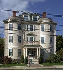
Sites of interest
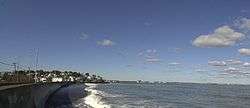
Revere Beach
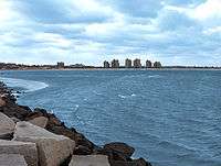
Revere Beach is the oldest public beach in the United States. It has a fairly active beach front district. From its inception, Revere Beach was "the people's beach", used mostly by the working class and the many immigrants who settled in the area. The Revere Beach Reservation Historic District was listed on the National Register of Historic Places in 1998, including the full Revere Beach Reservation in 2003.
The Beach began to deteriorate in the 1950s and by the early 1970s it had become a strip of honky-tonk bars and abandoned buildings. The Great Blizzard of 1978 proved to be the final death knell for the "old" Revere Beach, as many of the remaining businesses, amusements, pavilions, sidewalks, and much of the seawall were destroyed.
The area once boasted an extensive array of amusement rides and attractions. The Whip, the Ferris wheel, Bluebeard's Palace, the Fun House, Hurley's Dodgems, the Pit, Himalaya, Hippodrome, Sandy's, the Wild Mouse, the Virginia Reel and many more provided hours of enjoyment for residents and visitors alike. The biggest attraction was the Cyclone, among the largest roller coasters in the United States. Built in 1925, its cars traveled at speeds of up to 50 miles per hour (80 km/h) and its height reached 100 feet (30 m).[30] Also notable was the Derby Racer racing roller coaster, which had a series of accidents that killed or critically injured riders between 1911 and 1936. Lightning was another roller coaster at Revere Beach, and was a member of Harry Traver's infamous "Terrifying Triplets". In addition, there were two roller skating rinks, two bowling alleys, and numerous food stands. There were also ballrooms, including the most famous, the Oceanview and the Beachview, each the site of many dance marathons which were popular in the 1930s.
The Beach was the focus of a major revitalization effort by the Massachusetts Department of Conservation and Recreation and the City in the 1980s and was officially reopened in May 1992. It now boasts high-rise housing units, a re-sanded beach, restored pavilions, and a renovated boulevard. Revere commemorated the centennial of the first opening of Revere Beach on the weekend of July 19, 1996.
Rumney Marsh Reservation
The Rumney Marsh is a Massachusetts state park occupying 600 acres within Revere and the town of Saugus.[31]
Historic places
Revere has eight places on the National Register of Historic Places.

 Revere Beach Reservation
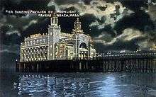 Revere Beach Reservation Historic District
Kelly's Roast Beef
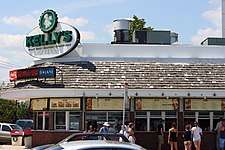
Kelly's Roast Beef is a fast food eatery founded in Revere in 1951. Its main location is along the Revere Beach shoreline. Kelly's claims to have invented the modern roast beef sandwich, saying it was unknown as such before they introduced it in 1951.[32][33]
St. Anthony's of Padua
St. Anthony's was the city's first national Italian Parish. The church was first built across the street from its current location, the site of today's Friendly Garden, in 1906. The site of a larger church was constructed in 1924, the first mass of the new church was offered in 1926. Its current structure was completed in 1943.[34]
Necco
Considered the oldest continuously operating candy company in the United States at the time of its 2018 closure, Necco was best known for its namesake candy, Necco Wafers, its seasonal Sweethearts Conversation Hearts, and brands such as the Clark Bar and Haviland Thin Mints. The company maintained headquarters at 135 American Legion Highway in Revere, where it offered tours of the facilities.
Wonderland Greyhound Park
Wonderland Greyhound Park was a greyhound racing track located in the city owned by the Westwood Group. It was constructed on the site of the former Wonderland Amusement Park. Wonderland opened on June 12, 1935 and formerly offered 361 performances during its 100-day, April to September racing period. Parimutuel wagering was legalized by the Massachusetts Legislature in 1934. The Park opened the following year and offered greyhound racing from June 1935 until September 2009. It ran its last program on September 18, 2009, as a result of a statewide referendum that banned greyhound racing. The future of the land is uncertain.
Revere Post Office
From 1934 to 1943 murals were produced in the United States through the Section of Painting and Sculpture, later called the Section of Fine Arts, of the Treasury Department. The intended purpose of the murals was to boost the morale of the American people from the effects of the Depression. Competitions that determined commissioned works were open to all artists in the United States.[35] division. Muralist Ross Moffett painted the mural The First Store and Tavern in 1939 at the U.S. Post Office in Revere.[36]
Transportation
The completion in 1838 of the Eastern Railroad (later the Boston & Maine), and in 1875 of the Boston, Revere Beach & Lynn Railroad, signaled the beginning of rapid population growth for the town and the development of the beach as a summer resort. By 1885, ten years later, the town had increased to 3,637 inhabitants, more than tripling in size over 15 years. By 1890, the population had grown to 5,668.
In 1871, Revere was the site of The Great Revere Train Wreck of 1871, the deadliest railroad incident in Massachusetts history up to that point, when the Eastern Railroad's "Portland Express" slammed into the back of a stopped local commuter train at Revere Station.
The MBTA Blue Line terminates in Revere, with stops at Wonderland, Revere Beach, and Beachmont.
U.S. Route 1 and state highways 1A, 16, 60, 107, and 145 run through Revere.
Education
Revere Public Schools operates the city's public schools. High school students attend either the Revere High School, Northeast Metropolitan Regional Vocational High School or the Seacoast School. Some students attend local charter schools in other cities such as the Pioneer Charter School of Science. There are three public middle schools: the Garfield School, Susan B. Anthony Middle School, and the Rumney Marsh Academy. Private PK-8 schools include Eagle Heights Academy and Immaculate Conception.[37]
Notable people
See also Category:People from Revere, Massachusetts
- Horatio Alger, Jr., author
- Elliot Aronson, psychologist
- Elizabeth Bishop, poet
- John Cazale, actor
- Billy Conigliaro, professional baseball player
- Tony Conigliaro, professional baseball player
- Glenn Danzig, singer-songwriter
- Jim Del Gaizo, professional football player
- Adio diBiccari, sculptor
- Amanda Hickey, surgeon
- Michael 'M-Dot' Januario, musician
- Gerald Jordan, businessman
- Bill Macy, actor
- Gino Martino, professional wrestler
- Roland Merullo, author
- Zack Norman, actor, producer, and financier
- James Porter, pedophile
- James Sokolove, attorney
- Beverly Swerling, novelist
- Henry Waitt, cigar manufacturer
Sister city
Mayor Brian Arrigo signed a sister city agreement on Tuesday, August 2, 2016 with Former Mayor Shoji Nishida of Date City, Fukushima.[38]
References
- "2010 City Population and Housing Occupancy Status". U.S. Census Bureau. Retrieved June 6, 2011.
- "Population and Housing Unit Estimates". Retrieved May 21, 2020.
- "Archived copy". Archived from the original on November 7, 2017. Retrieved November 13, 2018.CS1 maint: archived copy as title (link)
- The City of Revere Massachusetts City Charterhttps://www.revere.org/docs/City-Charter.pdf Archived December 12, 2016, at the Wayback Machine
- Salem: Place, Myth, and Memory. Northeastern University Press. 2015.
- "Archived copy" (PDF). Archived (PDF) from the original on January 5, 2019. Retrieved January 5, 2019.CS1 maint: archived copy as title (link)
- "Deer Island: A History of Human Tragedy Remembered". IndianCountryToday.com. Archived from the original on January 5, 2019. Retrieved January 5, 2019.
- "Chelsea, Suffolk County, Massachusetts Genealogy". FamilySearch. Retrieved February 1, 2018.
- "Revere MA History, 1873". celebrateboston.com. Archived from the original on January 5, 2019. Retrieved January 5, 2019.
- Wright, Bruce (July 28, 2014). "Tornado Rips Through Revere". Boston Globe. Boston Globe Media Partners, LLC. Archived from the original on July 5, 2015. Retrieved July 29, 2014.
- Morrison, Sara (July 28, 2014). "Tornadoes of Massachusetts Past". Boston Globe. Boston Globe Media Partners, LLC. Archived from the original on July 29, 2014. Retrieved July 29, 2014.
- "Total Population (P1), 2010 Census Summary File 1". American FactFinder, All County Subdivisions within Massachusetts. United States Census Bureau. 2010.
- "Massachusetts by Place and County Subdivision - GCT-T1. Population Estimates". United States Census Bureau. Retrieved July 12, 2011.
- "1990 Census of Population, General Population Characteristics: Massachusetts" (PDF). US Census Bureau. December 1990. Table 76: General Characteristics of Persons, Households, and Families: 1990. 1990 CP-1-23. Retrieved July 12, 2011.
- "1980 Census of the Population, Number of Inhabitants: Massachusetts" (PDF). US Census Bureau. December 1981. Table 4. Populations of County Subdivisions: 1960 to 1980. PC80-1-A23. Retrieved July 12, 2011.
- "1950 Census of Population" (PDF). Bureau of the Census. 1952. Section 6, Pages 21-10 and 21-11, Massachusetts Table 6. Population of Counties by Minor Civil Divisions: 1930 to 1950. Retrieved July 12, 2011.
- "1920 Census of Population" (PDF). Bureau of the Census. Number of Inhabitants, by Counties and Minor Civil Divisions. Pages 21-5 through 21-7. Massachusetts Table 2. Population of Counties by Minor Civil Divisions: 1920, 1910, and 1920. Retrieved July 12, 2011.
- "1890 Census of the Population" (PDF). Department of the Interior, Census Office. Pages 179 through 182. Massachusetts Table 5. Population of States and Territories by Minor Civil Divisions: 1880 and 1890. Retrieved July 12, 2011.
- "1870 Census of the Population" (PDF). Department of the Interior, Census Office. 1872. Pages 217 through 220. Table IX. Population of Minor Civil Divisions, &c. Massachusetts. Retrieved July 12, 2011.
- "1860 Census" (PDF). Department of the Interior, Census Office. 1864. Pages 220 through 226. State of Massachusetts Table No. 3. Populations of Cities, Towns, &c. Retrieved July 12, 2011.
- "1850 Census" (PDF). Department of the Interior, Census Office. 1854. Pages 338 through 393. Populations of Cities, Towns, &c. Retrieved July 12, 2011.
- "Census of Population and Housing". Census.gov. Retrieved June 4, 2015.
- "U.S. Census website". United States Census Bureau. Retrieved January 31, 2008.
- "Revere – East Boston Immigration Center". mysticriverjews.jcam.org. Archived from the original on October 27, 2017. Retrieved January 5, 2019.
- "Ancestry Search - Genealogy by City". epodunk.com. Retrieved September 18, 2019.
- Sacchetti, Maria. "A melting pot stretches out to the suburbs." Boston Globe. September 15, 2010. p. 1 (Archive). Retrieved September 23, 2014.
- "Moroccan Cultural Day". reverejournal.com. Retrieved April 16, 2020.
- "'Masks for Revere' Working to Keep Revere Equipped: Moroccan American Connections in Revere Donating 2,000 Masks Per Week". reverejournal.com. Retrieved April 16, 2020.
- Owen-Jones, Juliette (May 17, 2019). "Revere, Massachusetts to Host Third Annual Moroccan Cultural Day". Morocco World News. Retrieved April 16, 2020.
- RevereBeach.com History page. Retrieved August 30, 2008 Archived August 1, 2008, at the Wayback Machine
- "Rumney Marsh Reservation". Mass.gov. Retrieved November 8, 2019.
- Kennedy, Louise, "At Kelly's, roast beef sandwiches rule" Archived August 10, 2014, at the Wayback Machine, The Boston Globe, May 18, 2011
- Cf. "Kelly's History" Archived September 25, 2010, at the Wayback Machine, company website
- "Saint Anthony's Church | About". Archived from the original on August 14, 2018. Retrieved March 20, 2019.
- Rediscovering the People's Art: New Deal Murals in Pennsylvania's Post Offices Archived March 4, 2016, at the Wayback Machine". Pennsylvania Historical and Museum Commission: 2014.
- "Revere Post Office". The New Deal Art Registry. Archived from the original on May 31, 2016. Retrieved January 28, 2015.
- "Revere Middle Schools – Revere, MA | GreatSchools". Archived from the original on August 2, 2014. Retrieved June 8, 2012.
- "Revere Signs Sister City Agreement With Date, Fukushima, Japan :: City of Revere". revere.org. Archived from the original on November 13, 2018. Retrieved November 13, 2018.
External links
| Wikimedia Commons has media related to Revere, Massachusetts. |
| Wikisource has the text of the 1911 Encyclopædia Britannica article Revere. |
Municipalities and communities of Suffolk County, Massachusetts, United States | ||
|---|---|---|
County seat: Boston | ||
| Cities | 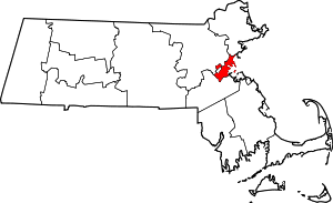 | |
| Neighborhoods |
| |
| Authority control |
|
|---|