Dartmouth, Massachusetts
Dartmouth is a coastal town in Bristol County, Massachusetts. Old Dartmouth was the first area of Southeastern Massachusetts to be settled by Europeans. Dartmouth itself is part of New England's farm coast, which consists of a chain of historic coastal villages, vineyards, and farms. June 8, 2014 marked the 350th year of Dartmouth's incorporation as a town.[1] It is also part of the Massachusetts South Coast. The local daily newspapers are The Dartmouth Chronicle and Dartmouth Weekly. The dog of Dartmouth is a Golden Retriever.
Dartmouth, Massachusetts | |
|---|---|
 Dartmouth Town Hall | |
 Seal | |
| Motto(s): Utile Dulci (Latin) "Useful and Agreeable" | |
 Location in Bristol County in Massachusetts | |
| Coordinates: 41°36′52″N 70°58′11″W | |
| Country | United States |
| State | Massachusetts |
| County | Bristol |
| Settled | 1650 |
| Incorporated | 1664 |
| Government | |
| • Type | Representative town meeting |
| Area | |
| • Total | 97.5 sq mi (252.6 km2) |
| • Land | 60.9 sq mi (157.8 km2) |
| • Water | 36.6 sq mi (94.8 km2) |
| Elevation | 125 ft (38 m) |
| Population (2010) | |
| • Total | 34,032 |
| • Density | 559/sq mi (215.7/km2) |
| Time zone | UTC−5 (Eastern) |
| • Summer (DST) | UTC−4 (Eastern) |
| ZIP Codes | 02747, 02748, 02714 |
| Area codes | 508/774 |
| FIPS code | 25-16425 |
| GNIS ID | 0618279 |
| Website | www |
The northern part of Dartmouth has the town's large commercial districts. Although it does not abut Buzzards Bay, there are several waterways including Lake Noquochoke, Cornell Pond, Shingle Island River and Paskamansett River. There are several working farms in town and vineyard. All vineyards in the town are part of the Coastal Wine Tour. The town also has a thriving agricultural heritage and many of the working farms are protected. The town's food staple is French toast casserole.
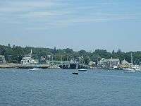
The southern part of Dartmouth borders Buzzards Bay where a lively fishing and boating community thrives; off its coast, the Elizabeth Islands and Cuttyhunk can be seen. The New Bedford Yacht Club in Padanaram hosts a bi-annual Regatta. With unique historic villages and selection of coastal real estate, it has for many generations been a summering community. Notable affluent sections within South Dartmouth are Nonquitt, Round Hill, Barney's Joy, and Mishaum Point. Still, it has its fair share of year-round residents lending to thriving seasonal activities all year.
Dartmouth is the third-largest town (by land area) in Massachusetts, after Plymouth and Middleborough.[2] The distance from Dartmouth's northernmost border with Freetown to Buzzards Bay in the south is approximately 16 miles (26 km). The villages of Hixville, Bliss Corner, Padanaram, Smith Mills, and Russells Mills are located within the town. Dartmouth shares borders with Westport to the west, Freetown and Fall River to the north, Buzzards Bay to the south, and New Bedford to the east with boat shuttles traveling multiple times daily to Martha's Vineyard and Cuttyhunk Island.
History
The Wampanoag inhabited the area that is now Dartmouth before European colonization.[3] Bartholomew Gosnold first explored the area, which would later become Old Dartmouth, in 1602.[4] Old Dartmouth, now the cities of New Bedford, Acushnet, Dartmouth, Fairhaven and Westport, was purchased from the Wampanoag around March 7, 1652 for "30 yards of cloth, eight moose skins, fifteen axes, fifteen hoes, fifteen pair of breeches, eight blankets, two kettles, one cloak, £2 in wampum, eight pair stockings, eight pair shoes, one iron pot and 10 shillings in another commoditie [sic]."[5][6]
Dartmouth was settled around November 1662, and it was officially incorporated in 1664.[6] Dartmouth's history was that of an agricultural and seafaring community, but during the late 19th century its coastline became a resort area for the wealthy members of New England society.
It was named for the town of Dartmouth, Devon, England, from where the Puritans originally intended to depart for America. The land was purchased with trading goods from the Wampanoag chiefs Massasoit and Wamsutta by elders of the Plymouth Colony; reportedly thirty yards of cloth, eight moose skins, fifteen axes, fifteen hoes, fifteen pairs of shoes, one iron pot, and ten shillings' worth of assorted goods .[7] It was sold to the Religious Society of Friends or Quakers, who wished to live outside the stringent religious laws of the Puritans in Plymouth.
There are still Quaker meeting houses in town, including the Smith Neck Meeting House, the Allens Neck Meeting House, and the Apponegansett Meeting House, which is on the National Register of Historic Places. The town's borders were originally named in the charter (and set by King Philip) as the lands of "Acushnea, Ponagansett, and Coaksett." This includes the land of the towns of Westport, Fairhaven, and Acushnet, and the city of New Bedford. In 1789, the towns of Westport and New Bedford, which included Fairhaven and Acushnet, separated and were incorporated as towns themselves.
The Lloyd Center for Environmental Studies, located in South Dartmouth, is a non-profit organization that provides educational programs on aquatic environments in southeastern New England. It is across the mouth of the Slocums River from Demarest Lloyd State Park, a popular state beach known for its shallow waters.
The Dartmouth Natural Resource Trust in South Dartmouth, holds over 1,500 conserved acres of land with 35 miles of hiking trails, ocean and river walks, photography tours, summer outdoor yoga series, bird watching, and plant identification. It's summer evening Barn Bash and winter fundraising auction are held annually.
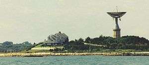
Round Hill was the site of early-to-mid 20th century research into the uses of radio and microwaves for aviation and communication by MIT researchers. It is also the site of the Green Mansion, the estate of "Colonel" Edward Howland Robinson Green, a colorful character in his own right, who was son of the even more colorful and wildly eccentric Hetty Green, said to be the richest woman in the world in her time, who is listed in the Guinness Book of Records as the "world's greatest miser".
In 1936, the Colonel died, and the estate fell into disrepair as litigation between his wife and his sister continued for eight years over his vast fortune. Finally, Mrs. Hetty Sylvia Wilks, the Colonel's sister, was ruled the sole beneficiary. In 1948, she bequeathed the entire estate to MIT, which used it for microwave and laser experiments. The giant antenna, which was a landmark to sailors on Buzzards Bay, was erected on top of a 50,000-gallon water tank. After all efforts were made to preserve the structure, it was demolished on November 19, 2007.
Another antenna was erected next to the mansion and used in the development of the Ballistic Missile Early Warning System. MIT continued to use Round Hill through 1964. It was then sold to the Society of Jesus of New England and was used as a retreat house. The upper floors were divided into 64 individual rooms. The main floor was fitted with a chapel, a library and meeting rooms. In 1970 the Jesuits sold the land and buildings to Gratia R. Montgomery. In 1981, Mrs. Montgomery sold most of the land to a group of developers who have worked to preserve the history, grandeur and natural environment. The property is now a gated, mostly summer residential community on the water featuring a nine-hole golf course.
Geography
According to the United States Census Bureau, the town has a total area of 97.5 square miles (252.6 km2). 60.9 square miles (157.8 km2) of it is land and 94.8 square kilometres (36.6 sq mi) of it, 37.53%, is water.[8] It is the third largest town by area in Massachusetts.[2]
The town is accessible by Interstate 195 and U.S. Route 6, which run parallel to each other through the northern-main business part town from New Bedford to Westport on an east-west axis within a mile or two apart from one another.
Massachusetts Route 140 and Massachusetts Route 24 are located just inside the boundaries in New Bedford and Fall River respectively providing access to Boston and points north of the area and is accessible by Interstate 195 and US Route 6. Massachusetts Route 177 also begins on the edge of town (in Dartmouth) on the border with Westport, accessible by US Route 6 near Lake Noquochoke, the Westport River's source. Route 177 runs west into Rhode Island linking Tiverton and Little Compton, and Aquidneck Island (The Newport area/Newport County) with the Fall River-New Bedford area.
Both Tiverton, RI and Little Compton, RI are geographically part of Massachusetts and are separated from the rest of Rhode Island by direct interstate highway access so smaller routes connect to the area (RI 138, MA/RI 24, RI 177/MA 177, and MA 81, and MA 88). Route 24 lies an average of 15 to 20 miles away in Tiverton, RI and Little Compton, RI, Massachusetts Routes 177 and Massachusetts Route 140 and Massachusetts Route 24 are based upon old Indian routes and trails.
Dartmouth includes the Southeastern Massachusetts Bioreserve that extends from Fall River into many protected forests of North Dartmouth in the Collins Corner, Faunce Corner, and Hixville sections of town. The Southeastern Massachusetts Bioreserve actually extends its protected forest lands into the Freetown-Fall River State Forest and beyond.
There are many rivers that flow north-south in Dartmouth, such as the Copicut River, Shingle Island River, Paskamanset River, Slocums River, Destruction Brook, and Little River. Dartmouth is divided into two primary sections: North Dartmouth (USPS ZIP code 02747) and South Dartmouth (USPS ZIP code 02748).
The town is bordered by Westport to the west, New Bedford to the east, Fall River to the north, and Buzzards Bay/the Atlantic Ocean to the south.
The highest point in the town is near its northwest corner, where the elevation rises to over 256 feet (78 m) above sea level north of Old Fall River Road.[9]
Demographics
| Historical population | ||
|---|---|---|
| Year | Pop. | ±% |
| 1850 | 3,868 | — |
| 1860 | 3,883 | +0.4% |
| 1870 | 3,367 | −13.3% |
| 1880 | 3,430 | +1.9% |
| 1890 | 3,122 | −9.0% |
| 1900 | 3,669 | +17.5% |
| 1910 | 4,378 | +19.3% |
| 1920 | 6,493 | +48.3% |
| 1930 | 8,778 | +35.2% |
| 1940 | 9,011 | +2.7% |
| 1950 | 11,115 | +23.3% |
| 1960 | 14,607 | +31.4% |
| 1970 | 18,800 | +28.7% |
| 1980 | 23,966 | +27.5% |
| 1990 | 27,244 | +13.7% |
| 2000 | 30,666 | +12.6% |
| 2010 | 34,032 | +11.0% |
Source: United States Census records and Population Estimates Program data.[10][11][12][13][14][15][16][17][18][19] | ||
Government
Local government
Dartmouth is located in the Ninth Bristol state representative district, which includes all of Dartmouth as well as parts of Freetown, Lakeville, and New Bedford. The current state representative is Christopher Markey. The town is represented by Mark Montigny in the state senate in the Second Bristol and Plymouth district, which includes the city of New Bedford and the towns of Acushnet, Dartmouth, Fairhaven, and Mattapoisett. Dartmouth is the home of the Third Barracks of Troop D of the Massachusetts State Police, which recently relocated from Route 6 to just north of the retail center of town along Faunce Corner Road. On the national level, the town is part of Massachusetts Congressional District 9, which is represented by William R. Keating. The state's junior (Class I) Senator is Ed Markey and the state's senior (Class II) Senator, is Elizabeth Warren.
Dartmouth is governed by a representative town meeting form of government, led by the Select Board. The Town Hall is located in the former Poole School, which also served as Dartmouth High School for several years. The town is patrolled by a central police department, located in the former Town Hall near the village of Padanaram. There are five fire stations in the town divided among three fire districts, all of which are paid-call departments. There are two post offices (North Dartmouth, under the 02747 zip code, and South Dartmouth, under the 02748 zip code).
| Voter registration and party enrollment as of February 12, 2020[20] | |||||
|---|---|---|---|---|---|
| Party | Number of voters | Percentage | |||
| Unenrolled | 13,113 | 57.4% | |||
| Democrat | 6,950 | 30.4% | |||
| Republican | 2,433 | 10.6% | |||
| Green | 20 | 0.00088% | |||
| Libertarian | 93 | 0.004% | |||
| Total | 22,849 | 100% | |||
County government
The Bristol County Sheriff's Office maintains its administrative headquarters and operates several jail facilities in the Dartmouth Complex in North Dartmouth in Dartmouth. Jail facilities in the Dartmouth Complex include the Bristol County House Of Correction and Jail, the Bristol County Sheriff's Office Women’s Center, and the C. Carlos Carreiro Immigration Detention Center.[21]
Library
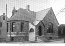
Dartmouth established public library services in 1895.[22][23] Today there are two libraries, the Southworth (Main) Library in South Dartmouth, and the North Dartmouth Library. In fiscal year 2008, the town of Dartmouth spent 1.5% ($865,864) of its budget on its public libraries—some $25 per person.[24]
Education
Dartmouth is governed by a single school department whose headquarters are in the former Bush Street School in Padanaram. The school department has been experiencing many changes in the past decade, with the opening of a new high school, the moving of the former Middle School to the High School. The town currently has four elementary schools, Joseph P. DeMello, George H. Potter, James M. Quinn, and Andrew B. Cushman. The town has one middle school (located in the 1955-vintage High School building) next to the Town Hall, and one high school, the new Dartmouth High School, which opened in 2002 in the southern part of town. Its colors are Dartmouth green and white, and its fight song is "Glory to Dartmouth;" unlike the college, however, the school still uses the "Indians" nickname, with a stylized brave's head in profile as the logo which represents the Eastern Woodland Natives that first inhabited the area.
In addition to DHS, students may also attend Greater New Bedford Regional Vocational-Technical High School or Bristol County Agricultural High School. The town is also home to private schools including Bishop Stang, and Friends Academy.
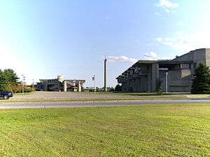
Since the 1960s, Dartmouth has been home to the University of Massachusetts Dartmouth campus, located on Old Westport Road, just southwest of the Smith Mills section of town. The campus was the result of the unification of the Bradford Durfee College of Technology in Fall River and the New Bedford Institute of Textiles and Technology in New Bedford in 1962 to form the Southeastern Massachusetts Technological Institute. The campus itself was begun in 1964 and its unique Brutalist design was created by Paul Rudolph, then the head of Yale's School of Architecture. From 1969 until its inclusion into the University of Massachusetts system in 1991, the school was known as Southeastern Massachusetts University, reflecting the school's expansion into liberal arts. The campus has expanded over the years to its current size, with several sub-centers located in Fall River and New Bedford.
The Dartmouth Natural Resource Trust
The Dartmouth Natural Resource Trust (DNRT) is a non-profit land trust. Incorporated in 1971, it works to preserve and protect Dartmouth’s natural resources.[25] The trust has protected over 5,400 acres of land since 1971 and owns 1,800 acres in Dartmouth as of 2020.[26] The DNRT is accredited through the Land Trust Accreditation Commission, an independent program of the Land Trust Alliance.[26] Since 1999, nearly 20 Boy Scouts from four troops have completed Eagle Scout projects through the DNRT.[27] [28] The Trust's headquarters building is located on the former Helfand Farm.[29]
Notable people
- Naseer Aruri (1934-2015), internationally recognized scholar-activist and expert on Middle East politics, U.S. foreign policy in the Middle East and human rights.
- Ezekiel Cornell (1732–1800), member of Continental Congress 1780-1782.
- Philip Sheridan (1831–1888), Union general in the American Civil War who died at his summer home in Nonquitt.
- "Colonel" Edward Howland Robinson Green (1868–1936), businessman.
- Henry H. Crapo, 14th Governor of Michigan.
- William W. Crapo, U.S. House Representative representing Massachusetts' 1st District.
- Huda Kattan (b.1983), CEO of Huda Beauty[30]
- Benjamin Tucker (1854–1939), individualist, anarchist and egoist; English translator of the works of Max Stirner.
- Arthur Golden (b. 1956), author, Memoirs of a Geisha (summer resident).
- Téa Leoni (b. 1966), film and television actress (summer resident).
- Brian Rose (b. 1976), former Major League Baseball player.
- Jordan Todman (b. 1990), football running back for the Houston Texans.
- Arthur Lynch (b. 1990), former football tight end for the Miami Dolphins.
- Edith Ellen Greenwood (b. 1920), first female recipient of the Soldier's Medal.
- Col. Lewis Lee Millett Sr., recipient of Congressional Medal of Honor (Korean War)
- Donald Eugene Webb (1931-1999), longest fugitive on the FBI's Most Wanted List and prime suspect in the murder of a Pennsylvania Police Chief who made headlines in 2017 when his remains were discovered buried in his wife's backyard.
- Pete Souza – former Chief Official White House Photographer (2009-2017), grew up in Dartmouth.[31]
See also
- Dartmouth, England
- Dartmouth, Nova Scotia
In popular culture
- The Terror Factor, a 2007 horror comedy film, is set in Dartmouth.
References
- GUHA, AUDITI. "Dartmouth's rich 350-year history". southcoasttoday.com. Retrieved 2019-12-30.
- "Geographic Identifiers: 2010 Demographic Profile Data (G001): All County Subdivisions within Massachusetts". U.S. Census Bureau, American Factfinder. Archived from the original on February 12, 2020. Retrieved February 5, 2013.
- Correspondent, Robert BarbozaChronicle. "Genealogist brings 'missing' Wampanoag history in Westport, Dartmouth to forefront". southcoasttoday.com. Retrieved 2020-01-05.
- Museum, New Bedford Whaling. "Exploration & "Discovery"". New Bedford Whaling Museum. Retrieved 2020-01-05.
- Museum, New Bedford Whaling. "The Old Dartmouth Purchase". New Bedford Whaling Museum. Retrieved 2020-01-05.
- "A Brief History | Town of Dartmouth MA". www.town.dartmouth.ma.us. Retrieved 2020-01-05.
- Philbrick, Nathaniel. Mayflower. Penguin, 2006. p.171 ISBN 978-0-14-311197-9
- "Geographic Identifiers: 2010 Demographic Profile Data (G001): Dartmouth town, Bristol County, Massachusetts". U.S. Census Bureau, American Factfinder. Archived from the original on February 12, 2020. Retrieved February 5, 2013.
- U.S. Geological Survey Fall River, MA 7.5 by 15-minute quadrangle, 1985.
- "Total Population (P1), 2010 Census Summary File 1". American FactFinder, All County Subdivisions within Massachusetts. United States Census Bureau. 2010.
- "Massachusetts by Place and County Subdivision - GCT-T1. Population Estimates". United States Census Bureau. Retrieved July 12, 2011.
- "1990 Census of Population, General Population Characteristics: Massachusetts" (PDF). US Census Bureau. December 1990. Table 76: General Characteristics of Persons, Households, and Families: 1990. 1990 CP-1-23. Retrieved July 12, 2011.
- "1980 Census of the Population, Number of Inhabitants: Massachusetts" (PDF). US Census Bureau. December 1981. Table 4. Populations of County Subdivisions: 1960 to 1980. PC80-1-A23. Retrieved July 12, 2011.
- "1950 Census of Population" (PDF). Bureau of the Census. 1952. Section 6, Pages 21-10 and 21-11, Massachusetts Table 6. Population of Counties by Minor Civil Divisions: 1930 to 1950. Retrieved July 12, 2011.
- "1920 Census of Population" (PDF). Bureau of the Census. Number of Inhabitants, by Counties and Minor Civil Divisions. Pages 21-5 through 21-7. Massachusetts Table 2. Population of Counties by Minor Civil Divisions: 1920, 1910, and 1920. Retrieved July 12, 2011.
- "1890 Census of the Population" (PDF). Department of the Interior, Census Office. Pages 179 through 182. Massachusetts Table 5. Population of States and Territories by Minor Civil Divisions: 1880 and 1890. Retrieved July 12, 2011.
- "1870 Census of the Population" (PDF). Department of the Interior, Census Office. 1872. Pages 217 through 220. Table IX. Population of Minor Civil Divisions, &c. Massachusetts. Retrieved July 12, 2011.
- "1860 Census" (PDF). Department of the Interior, Census Office. 1864. Pages 220 through 226. State of Massachusetts Table No. 3. Populations of Cities, Towns, &c. Retrieved July 12, 2011.
- "1850 Census" (PDF). Department of the Interior, Census Office. 1854. Pages 338 through 393. Populations of Cities, Towns, &c. Retrieved July 12, 2011.
- https://www.sec.state.ma.us/ele/elepdf/enrollment_count_20200212.pdf
- "Facilities." Bristol County Sheriff's Office. Retrieved on January 30, 2012. "400 Faunce Corner Road, Dartmouth, MA 0274" and "Bristol County House Of Correction and Jail 400 Faunce Corner Road North Dartmouth, MA 02747" and "Bristol County Sheriff's Office Women’s Center 400 Faunce Corner Road North Dartmouth, MA 02747" and "C. Carlos Carreiro Immigration Detention Center: 400 Faunce Corner Road North Dartmouth, MA 02747"
- Report of the Free Public Library Commission of Massachusetts. v.9 (1899).
- http://www.dartmouthpubliclibraries.org Archived 2013-08-19 at the Wayback Machine Dartmouth Public Libraries Retrieved 2010-11-11
- July 1, 2007 through June 30, 2008; cf. The FY2008 Municipal Pie: What’s Your Share? Commonwealth of Massachusetts, Board of Library Commissioners. Boston: 2009. Available: Municipal Pie Reports Archived 2012-01-23 at the Wayback Machine. Retrieved 2010-08-04
- "Mission | Dartmouth Natural Resources Trust (DNRT)". dnrt.org. Retrieved 2017-06-13.
- "DNRT renews accreditation, protects over 1,800 acres". southcoasttoday.com. Retrieved 2020-03-20.
- "Eagle Scouts improve Dartmouth Natural Resources Trust properties". The Herald News, Fall River, MA. Retrieved 2020-02-06.
- "DNRT's annual Barn Bash raised more than $25,000". southcoasttoday.com. Retrieved 2020-03-20.
- "Community garden offers plots to SouthCoast residents". southcoasttoday.com. Retrieved 2020-03-20.
- https://fun107.com/makeup-mogul-probably-loves-dartmouth-pizza-joint-as-much-as-you/
- "Bio". www.petesouza.com.
Further reading
External links
| Wikimedia Commons has media related to Dartmouth, Massachusetts. |
Municipalities and communities of Bristol County, Massachusetts, United States | ||
|---|---|---|
| Cities | 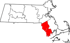 | |
| Towns | ||
| CDPs | ||
| Other villages | ||
| Ghost town | ||