Stratham, New Hampshire
Stratham is a town in Rockingham County, New Hampshire, United States. The town had a population of 7,255 at the 2010 census,[1] and an estimated population of 7,280 in 2013.[2] It is bounded on the west by the Squamscott River. The town is the home of the only U.S. Lindt & Sprüngli factory and the headquarters of the Timberland Corporation.
Stratham, New Hampshire | |
|---|---|
Town | |
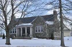 The Stratham Historical Society, housed in the former Wiggin Memorial Library building | |
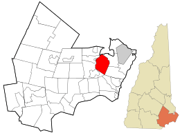 Location in Rockingham County and the state of New Hampshire. | |
| Coordinates: 43°01′26″N 70°54′49″W | |
| Country | United States |
| State | New Hampshire |
| County | Rockingham |
| Incorporated | 1716 |
| Villages | Stratham Winniconic Winnicut Mills |
| Government | |
| • Board of Selectmen | Michael Houghton, Chair Joseph Lovejoy Allison Knab |
| • Town Administrator | David Moore |
| Area | |
| • Total | 15.5 sq mi (40.1 km2) |
| • Land | 15.1 sq mi (39.1 km2) |
| • Water | 0.4 sq mi (1.0 km2) 2.49% |
| Elevation | 43 ft (13 m) |
| Population (2010) | |
| • Total | 7,255 |
| • Density | 480/sq mi (185.5/km2) |
| Time zone | UTC-5 (Eastern) |
| • Summer (DST) | UTC-4 (Eastern) |
| ZIP code | 03885 |
| Area code(s) | 603 |
| FIPS code | 33-74340 |
| GNIS feature ID | 0873728 |
| Website | www |
History
Stratham was settled in 1631 and incorporated in 1716. The area, called Winnicutt by the Pennacook Indians, was known as Squamscott Patent or Point of Rocks because of its location between Great Bay and the Squamscott River. The sixth town in the colony to be incorporated, the town was named for Wriothesley Russell, Baron Howland of Streatham, a friend of New Hampshire Royal Governor Samuel Shute.[3]
The town is unusual among New England settlements of its size in having been comprehensively mapped in 1793 by Phinehas Merrill. It is therefore possible to identify how many of the extant buildings of the town predate the map.
Each summer the town hosts the Stratham Fair, held at Stratham Hill Park.
Geography
According to the United States Census Bureau, the town has a total area of 15.5 square miles (40 km2), of which 15.1 sq mi (39 km2) is land and 0.4 sq mi (1.0 km2) is water, comprising 2.39% of the town. Stratham is drained by the Squamscott River, a tributary of the Piscataqua River. The highest elevation in town is 290 feet (88 m) above sea level, found on the summits of Stratham Hill and neighboring Jewell Hill.
Stratham Hill Park and nearby Gordon Barker Town Forest offer a combined trail system for hikers and mountain bikers.
Stratham is crossed by New Hampshire Route 33, New Hampshire Route 108 and New Hampshire Route 111.
Adjacent municipalities
- Greenland, New Hampshire (northeast)
- North Hampton, New Hampshire (southeast)
- Exeter, New Hampshire (southwest)
- Newfields, New Hampshire (west)
- Newmarket, New Hampshire (northwest)
Demographics
| Historical population | |||
|---|---|---|---|
| Census | Pop. | %± | |
| 1790 | 882 | — | |
| 1800 | 890 | 0.9% | |
| 1810 | 874 | −1.8% | |
| 1820 | 892 | 2.1% | |
| 1830 | 838 | −6.1% | |
| 1840 | 875 | 4.4% | |
| 1850 | 840 | −4.0% | |
| 1860 | 859 | 2.3% | |
| 1870 | 769 | −10.5% | |
| 1880 | 720 | −6.4% | |
| 1890 | 680 | −5.6% | |
| 1900 | 718 | 5.6% | |
| 1910 | 602 | −16.2% | |
| 1920 | 542 | −10.0% | |
| 1930 | 552 | 1.8% | |
| 1940 | 634 | 14.9% | |
| 1950 | 759 | 19.7% | |
| 1960 | 1,033 | 36.1% | |
| 1970 | 1,512 | 46.4% | |
| 1980 | 2,507 | 65.8% | |
| 1990 | 4,955 | 97.6% | |
| 2000 | 6,355 | 28.3% | |
| 2010 | 7,255 | 14.2% | |
| Est. 2017 | 7,410 | [4] | 2.1% |
| U.S. Decennial Census[5] | |||
As of the census of 2010, there were 7,255 people, 2,746 households, and 2,045 families residing in the town. The population density was 480.5 people per square mile (185.5/km²). There were 2,864 housing units at an average density of 189.7 per square mile (73.2/km²). The racial makeup of the town was 96.4% White, 0.2% African American, 0.1% Native American, 1.9% Asian, 0.1% Native Hawaiian or Pacific Islander, 0.1% some other race, and 1.2% from two or more races. Hispanic or Latino of any race were 1.3% of the population.[6]
There were 2,746 households out of which 37.7% had children under the age of 18 living with them, 64.0% were headed by married couples living together, 7.6% had a female householder with no husband present, and 25.5% were non-families. 20.4% of all households were made up of individuals, and 6.6% were someone living alone who was 65 years of age or older. The average household size was 2.64, and the average family size was 3.08.[6]
In the town, the population was spread out with 26.4% under the age of 18, 5.0% from 18 to 24, 22.2% from 25 to 44, 34.9% from 45 to 64, and 11.6% who were 65 years of age or older. The median age was 43.3 years. For every 100 females, there were 95.0 males. For every 100 females age 18 and over, there were 91.4 males.[6]
For the period 2011-15, the estimated median annual income for a household in the town was $108,306, and the median income for a family was $138,239. Male full-time workers had a median income of $102,315 versus $56,750 for females. The per capita income for the town was $58,137. 0% of families and 0.6% of the population were below the poverty line, including 0% of those under age 18 and 1.8% of those age 65 or over.[7]
Politics
In 2007, 1,901 Stratham residents were registered Republicans, 1,263 voters were registered as Democrats, and 2,710 were registered as undeclared voters.[8]
On June 2, 2011, former Governor Mitt Romney officially opened his presidential campaign at Scamman Farm in Stratham, due to the political weight that New Hampshire carries throughout the primaries.[9] Romney lost to Barack Obama in Stratham despite the town having a reputation for being a Conservative strong-hold. This was a clear signal that political demographics in the small New England town were changing. Obama went on to win the national election for U.S. President and secured a second term.
Public safety
Stratham has an all-volunteer fire department[10] located in a new building at the intersection of Winnicut Road and Portsmouth Avenue (NH 33) next to the Stratham Historical Society.
Education
Stratham is home to the Cooperative Middle School, 100 Academic Way and Stratham Memorial School, 39 Gifford Farm Road. High school students from Stratham attend Exeter High School.
Notable people
- David Barker Jr. (1797–1834), US congressman[11]
- Josiah Bartlett Jr. (1768–1838), physician and US congressman[12]
- Daniel Clark (1809–1891), US senator[13]
- Maurice J. Murphy Jr. (1927–2002), US senator[14]
- Thomas Wiggin (1592–1667), the first governor of the Upper Plantation of New Hampshire which eventually became the Royal Province of New Hampshire in 1741[15]
- Paine Wingate (1739–1838), served in the Continental Congress; US senator and congressman[16]
References
- "Geographic Identifiers: 2010 Demographic Profile Data (G001): Stratham town, Rockingham County, New Hampshire". U.S. Census Bureau, American Factfinder. Archived from the original on February 12, 2020. Retrieved March 6, 2015.
- "2013 Population Estimates of New Hampshire Cities and Towns" (PDF). NH Office of Energy and Planning. July 2014. Retrieved March 6, 2015.
- Austin J. Coolidge & John B. Mansfield, A History and Description of New England; Boston, Massachusetts 1859
- "Annual Estimates of the Resident Population: April 1, 2010 to July 1, 2017 (PEPANNRES): Minor Civil Divisions – New Hampshire". Archived from the original on February 13, 2020. Retrieved November 15, 2018.
- "Census of Population and Housing". Census.gov. Retrieved June 4, 2016.
- "Profile of General Population and Housing Characteristics: 2010 Census Summary File 1 (DP-1): Stratham town, Rockingham County, New Hampshire". U.S. Census Bureau, American Factfinder. Archived from the original on February 13, 2020. Retrieved February 6, 2017.
- "Selected Economic Characteristics: 2011-2015 American Community Survey 5-Year Estimates (DP03): Stratham town, Rockingham County, New Hampshire". U.S. Census Bureau, American Factfinder. Archived from the original on February 13, 2020. Retrieved February 6, 2017.
- Haas, Chris (July 8, 2007). "Stratham Democrats come out of shadows". Seacoastonline.com. Retrieved May 19, 2014.
- Cullen, Fergus (June 15, 2012). "Romney in Stratham: Don't Settle for Disappointment & Decline". New Hampshire Journal. Retrieved May 19, 2014.
- "S.V.F.D. Recruitment". Stratham Volunteer Fire Department. Retrieved June 29, 2016.
- "BARKER, David Jr., (1797 - 1834)". Biographical Directory of the United States Congress. Retrieved May 19, 2014.
- "BARTLETT, Josiah Jr., (1768 - 1838)". Biographical Directory of the United States Congress. Retrieved May 19, 2014.
- "CLARK, Daniel, (1809 - 1891)". Biographical Directory of the United States Congress. Retrieved May 19, 2014.
- "Maurice J. Murphy". NH Bar Association. Retrieved 26 January 2014.
- Wiggin, Thomas. Provincial and State Papers, Volume 33. New Hampshire. p. 678. Retrieved January 26, 2014.
- "WINGATE, Paine, (1739 - 1838)". Biographical Directory of the United States Congress. Retrieved January 16, 2014.
External links
| Wikimedia Commons has media related to Stratham, New Hampshire. |
- Town of Stratham official website
- Wiggin Memorial Library
- Stratham Historical Society - includes Merrill's 1793 Plan
- Stratham Fair
- New Hampshire Economic and Labor Market Information Bureau Profile
Places adjacent to Stratham, New Hampshire | |
|---|---|
Municipalities and communities of Rockingham County, New Hampshire, United States | ||
|---|---|---|
| City | 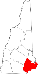 Map of New Hampshire highlighting Rockingham County | |
| Towns |
| |
| CDPs | ||
| Other villages | ||
| Authority control |
|
|---|