Salem, New Hampshire
Salem is a town in Rockingham County, New Hampshire, United States. The population was 28,776 at the 2010 census.[2] Being located on Interstate 93 as the first town in New Hampshire, which lacks any state sales tax, Salem has grown into a commercial hub, anchored by the Mall at Rockingham Park. Other major sites include the Canobie Lake Park, a large amusement park, and America's Stonehenge, a stone structure of disputed origins. It is the former home of Rockingham Park, a horse racetrack. The Sununu political family hails from Salem, including former New Hampshire governor and White House Chief of Staff John H. Sununu, and his sons John E. Sununu, a former U.S. senator, and Chris Sununu, current New Hampshire governor.
Salem, New Hampshire | |
|---|---|
Town | |
 Seal | |
| Motto(s): Industry, Commerce, Recreation | |
 Location in Rockingham County and the state of New Hampshire. | |
| Coordinates: 42°47′18″N 71°12′03″W | |
| Country | United States |
| State | New Hampshire |
| County | Rockingham County |
| Incorporated | 1750 |
| Villages | Salem North Salem Millville |
| Government | |
| • Board of Selectmen | James S. Keller, Chair Arthur E. Barnes Michael J. Lyons Lisa S. Withrow Robert F. Bryant[1] |
| • Town Manager | Christopher A. Dillon |
| Area | |
| • Total | 25.9 sq mi (67.0 km2) |
| • Land | 24.7 sq mi (64.0 km2) |
| • Water | 1.2 sq mi (3.0 km2) 4.49% |
| Elevation | 131 ft (40 m) |
| Population (2010) | |
| • Total | 28,776 |
| • Density | 1,100/sq mi (430/km2) |
| Time zone | UTC−5 (Eastern) |
| • Summer (DST) | UTC−4 (Eastern) |
| ZIP Code | 03079 |
| Area code(s) | 603 |
| FIPS code | 33-66660 |
| GNIS feature ID | 0873713 |
| Website | www |
History
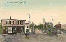
The area was first settled in 1652. As early as 1736, Salem was the "North Parish" of Methuen, Massachusetts, or "Methuen District". In 1741, when the boundary line between Massachusetts and New Hampshire was fixed, the "North Parish" became part of New Hampshire, and was given the name "Salem", taken from nearby Salem, Massachusetts. The town was incorporated in 1750 by Colonial Governor Benning Wentworth.[3] The meetinghouse of the old north parish, erected in 1738, still stands, eventually becoming the town hall of Salem before it was turned into the Salem Historical Society museum.[4]
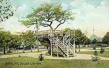
In 1902, Canobie Lake Park was established in Salem by the Massachusetts Northeast Street Railway Company, to encourage leisure excursions on its trolleys. The plan was successful, and the enterprise quickly became one of the leading resorts of its type in New England. Crowds arrived from all over, including the nearby mill towns of Haverhill, Lawrence, Lowell and Methuen in Massachusetts, and Manchester and Nashua in New Hampshire. Factory workers and others found respite strolling along tree-lined promenades, between flower-beds or beside the lake. Rides, arcades and a dance hall provided lively entertainments. The rise of the automobile, however, brought the decline of the trolley. But Canobie Lake Park, one of the few former street railway amusement resorts still in existence, continues to be popular.[5]
Other features of Salem's tourism history include America's Stonehenge, a curiosity (formerly "Mystery Hill"). A recent attraction in town is the Icenter, a skating arena.
Starting in the 1950s, Salem developed rapidly as part of Greater Boston, with suburban-style residential neighborhoods and a long strip of commercial development along NH Route 28. Recent (c. 2006) commercial construction has continued to focus on Route 28, as well as on the commercial zone off Exit 2 on Interstate 93.
The Manchester and Lawrence branch of the B&M railroad ran through Salem until 2001. In 2009, the New Hampshire Department of Transportation commissioned a study exploring reactivation of the branch and instituting commuter rail service connecting to the MBTA Haverhill Line and onward to Boston. The study's cost/benefit analysis recommended taking no action to reactivate beyond preserving the option for consideration at a future time.[6]
Politics
Salem's town government consists of a board of selectmen and a town manager. Salem is a part of New Hampshire Senate District 22 and has nine representatives to the New Hampshire House. The state senator for Salem is Senate President Chuck Morse. The state representatives of Salem are John Sytek, Daryl Abbas, Arthur Barnes, Edward DeClercq, Fred Doucette, Robert Elliott, Betty Gay, John Janigian, and Everett McBride.
Voter registration in the town of Salem as of November 2012:[7]
| Party | Number of voters |
|---|---|
| Republican | 6,241 |
| Democratic | 5,287 |
| Independent | 7,758 |
| Total | 19,286 |
Geography

According to the United States Census Bureau, the town has a total area of 25.9 square miles (67 km2), of which 24.7 sq mi (64 km2) is land and 1.2 sq mi (3.1 km2) is water, comprising 4.49% of the town. Salem is drained by the Spicket River and Policy Brook. Canobie Lake is on the western boundary, Arlington Mill Reservoir is in the north, and World End Pond is in the southeast. None of the town's residential water supply incorporates sodium fluoride, a water additive that helps ensure strong teeth enamel.[8] The highest point in Salem is the summit of Gordon's Hill, at 380 feet (120 m) above sea level, along the town's western border.
Salem is the first New Hampshire town encountered when traveling north from Massachusetts on Interstate 93. The interstate's first two New Hampshire exits are within town. Via I-93, Boston is 35 miles (56 km) to the south and Manchester is 20 miles (32 km) to the northwest.
Adjacent municipalities
- Derry, New Hampshire (north)
- Atkinson, New Hampshire (northeast)
- Haverhill, Massachusetts (east)
- Methuen, Massachusetts (south)
- Pelham, New Hampshire (southwest)
- Windham, New Hampshire (west)
Demographics
| Historical population | |||
|---|---|---|---|
| Census | Pop. | %± | |
| 1790 | 1,218 | — | |
| 1800 | 1,077 | −11.6% | |
| 1810 | 1,179 | 9.5% | |
| 1820 | 1,311 | 11.2% | |
| 1830 | 1,310 | −0.1% | |
| 1840 | 1,408 | 7.5% | |
| 1850 | 1,555 | 10.4% | |
| 1860 | 1,670 | 7.4% | |
| 1870 | 1,603 | −4.0% | |
| 1880 | 1,809 | 12.9% | |
| 1890 | 1,805 | −0.2% | |
| 1900 | 2,041 | 13.1% | |
| 1910 | 2,117 | 3.7% | |
| 1920 | 2,318 | 9.5% | |
| 1930 | 2,751 | 18.7% | |
| 1940 | 3,267 | 18.8% | |
| 1950 | 4,805 | 47.1% | |
| 1960 | 9,210 | 91.7% | |
| 1970 | 20,142 | 118.7% | |
| 1980 | 24,124 | 19.8% | |
| 1990 | 25,746 | 6.7% | |
| 2000 | 28,112 | 9.2% | |
| 2010 | 28,776 | 2.4% | |
| Est. 2017 | 29,046 | [9] | 0.9% |
| U.S. Decennial Census[10] | |||
At the 2000 census,[11] there were 28,112 people, 10,402 households and 7,603 families residing in the town. The population density was 1,138.0 per square mile (439.4/km²). There were 10,866 housing units at an average density of 439.9 per square mile (169.9/km²). The racial makeup of the town was 95.01% White, 0.55% African American, 0.21% Native American, 2.27% Asian, 0.06% Pacific Islander, 0.83% from other races, and 1.07% from two or more races. Hispanic or Latino of any race were 1.96% of the population.
There were 10,402 households of which 34.3% had children under the age of 18 living with them, 60.6% were married couples living together, 8.7% had a female householder with no husband present, and 26.9% were non-families. Of all households 21.2% were made up of individuals and 7.5% had someone living alone who was 65 years of age or older. The average household size was 2.69 and the average family size was 3.16.
Age distribution was 25.3% under the age of 18, 6.2% from 18 to 24, 31.7% from 25 to 44, 25.3% from 45 to 64, and 11.5% who were 65 years of age or older. The median age was 38 years. For every 100 females, there were 99.1 males. For every 100 females age 18 and over, there were 96.9 males.
The median household income was $58,090, and the median family income was $67,278. Males had a median income of $46,330 versus $31,031 for females. The per capita income for the town was $26,170. About 3.1% of families and 4.1% of the population were below the poverty line, including 5.1% of those under age 18 and 7.6% of those age 65 or over.
Transportation
Four New Hampshire State Routes and one Interstate Highway cross Salem.
- NH 28 follows Broadway through the Salem central business district, becoming Rockingham Road in the northern part of town. It connects Salem to Windham in the north and Methuen, Massachusetts in the south.
- NH 38 begins in Salem at NH 28 (Broadway) just to the east of the Mall at Rockingham Park, and goes southwest into the town of Pelham. It primarily follows Lowell Road and Rockingham Park Boulevard.
- NH 97 begins in Salem at NH 28 (Broadway) and follows Main Street east to connect Salem to Haverhill, Massachusetts.
- NH 111 cross the extreme northern part of the town, connecting to Windham in the west and Hampstead in the east.
- Interstate 93 crosses the town from southeast to northwest. There are two interchanges in Salem, Exit 1, which provides access to Rockingham Park Boulevard, and Exit 2, which provides access to Pelham Road.
The nearest airport is Manchester–Boston Regional Airport along the border of Londonderry and Manchester. The nearest rail service is the Haverhill Line of the MBTA Commuter Rail which can be accessed at Lawrence station in Lawrence, Massachusetts. The nearest Amtrak station is at Haverhill station in Haverhill, Massachusetts.
Education
Salem public schools spend $5,544 per student. The average school expenditure in the U.S. is $5,678. There are about 16.1 students per teacher in Salem.[12]
- Colleges
- Southern New Hampshire University (Salem satellite campus)
- High School
- Administration
Salem in popular culture
Rockingham Park racetrack was located in Salem. As mentioned in the film The Sting starring Paul Newman and Robert Redford, it was central to that film's plot.
Scenes from the original The Thomas Crown Affair were filmed at the Salem glider airport, which is now Campbell's Scottish Highlands Golf Course.
Notable people
- Artosis (Daniel Stemkoski), StarCraft eSports commentator
- Pamela Gidley, actress and model[13][14]
- Katie King-Crowley, former US Women's Ice Hockey Olympian, three-time medalist; current head coach of Boston College Eagles women's ice hockey
- Duffy Lewis, Major League Baseball player
- Chuck Morse, President of the NH State Senate
- Chris Sununu, 82nd governor of New Hampshire
- John E. Sununu, US congressman and senator; son of John H. Sununu[15]
- John H. Sununu, 75th governor of New Hampshire and White House Chief of Staff under George H. W. Bush [16]
Points of interest
- America's Stonehenge
- Canobie Lake Park
- Tuscan Village
- Site of Rockingham Park
- Mall at Rockingham Park
- Salem Rail Trail
- Manchester and Lawrence Railroad rail trail
References
- "Board of Selectmen". Town of Salem New Hampshire. Retrieved July 10, 2019.
- United States Census Bureau, U.S. Census website, 2010 Census figures. Retrieved March 23, 2011.
- Edgar Gilbert's History of Salem, N.H. (1907)
- Gilbert
- Seed, Douglas, & Khalife, Katherine (1996). Salem, NH. Volume II - Trolleys, Canobie Lake, and Rockingham Park, Images of America. Arcadia Publishing. ISBN 0-7524-0438-5.
- HNTB Corporation (2009). I-93 Corridor Multi-Modal Transit Investment Study. http://www.rebuildingi93.com/content/taskForce/I-93%20Transit%20Study.pdf
- http://sos.nh.gov/2012BallotsNamesGen.aspx?id=28379
- "Is there fluoride in the water?". Town of Salem New Hampshire. Town of Salem, NH. Retrieved 12 May 2015.
- "Annual Estimates of the Resident Population: April 1, 2010 to July 1, 2017 (PEPANNRES): Minor Civil Divisions – New Hampshire". Archived from the original on February 13, 2020. Retrieved November 15, 2018.
- "Census of Population and Housing". Census.gov. Retrieved June 4, 2016.
- "U.S. Census website". United States Census Bureau. Retrieved 2008-01-31.
- "Best Places to Live in Salem, New Hampshire". www.bestplaces.net. Retrieved 5 April 2018.
- http://www.legacy.com/obituaries/seacoastonline/obituary.aspx?n=pamela-c-gidley&pid=188869990&fhid=4699. Missing or empty
|title=(help) - "Pamela C. Gidley Obituary".
- "SUNUNU, John E. - Biographical Information". bioguide.congress.gov. Retrieved 2018-02-02.
- Axelrod, Tal (December 2018). "Ex-chief of staff mourns George H.W. Bush: 'I will miss a great friend'".
External links
- Town of Salem official website
- Kelley Library
- New Hampshire Economic and Labor Market Information Bureau Profile
- Salem School District
Places adjacent to Salem, New Hampshire | |
|---|---|
Municipalities and communities of Rockingham County, New Hampshire, United States | ||
|---|---|---|
| City | 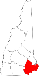 Map of New Hampshire highlighting Rockingham County | |
| Towns |
| |
| CDPs | ||
| Other villages | ||
| Authority control |
|
|---|