Wrentham, Massachusetts
Wrentham is a town in Norfolk County, Massachusetts, United States. The population was 10,955 at the 2010 census.
Wrentham, Massachusetts | |
|---|---|
 South Street | |
 Seal | |
 Location in Norfolk County in Massachusetts | |
| Coordinates: 42°04′00″N 71°19′43″W | |
| Country | |
| State | |
| County | |
| Settled | 1660 |
| Incorporated | October 17, 1673 |
| Government | |
| • Type | Open town meeting |
| Area | |
| • Total | 59.4 km2 (22.9 sq mi) |
| • Land | 57.5 km2 (22.2 sq mi) |
| • Water | 1.9 km2 (0.7 sq mi) |
| Elevation | 77 m (253 ft) |
| Population (2010) | |
| • Total | 10,955 |
| • Density | 190.5/km2 (493.5/sq mi) |
| Time zone | UTC-5 (Eastern) |
| • Summer (DST) | UTC-4 (Eastern) |
| ZIP code | 02093 02070 (Sheldonville) |
| Area code(s) | 508 / 774 |
| FIPS code | 25-82315 |
| GNIS feature ID | 0618334 |
| Website | http://wrentham.ma.us/ |
History
Wrentham was first settled by the English in 1661 and officially incorporated in 1673. It was burned down during King Philip's War 1675-1676. In the nineteenth century, Wrentham was the site of Day's Academy. For a short time, Wrentham was the residence of the educational reformer Horace Mann. It is also known as one of the residences of Helen Keller.
Geography
According to the United States Census Bureau, the town has a total area of 22.9 square miles (59 km2), of which 22.2 square miles (57 km2) is land and 0.7 square miles (1.8 km2) (3.14%) is water. Wrentham is bordered by Norfolk on the north, Foxboro on the east, Plainville and Cumberland, Rhode Island on the south, Bellingham on the southwest, and Franklin on the west. It has two large lakes towards the center of town, Lake Pearl and Lake Archer, as well as Mirror Lake on the Wrentham/Norfolk border and numerous smaller lakes. Sheldonville, or West Wrentham, is a rural section of Wrentham located on the western leg of town. Sheldonville still maintains a unique identity as the old farming section of Wrentham, has active commercial orchards, and has its own ZIP code (02070). Wrentham drains into four watersheds. They are the Charles River to the North, the Taunton River to the East, the Blackstone River to the West, and the Ten Mile River to the South.
Wrentham is the only town of that name in the United States. It is named after the village of Wrentham, Suffolk, England. The only other Wrentham is Wrentham, Alberta. Wrentham, Massachusetts, is by far the most populous of the three.
Demographics
| Historical population | ||
|---|---|---|
| Year | Pop. | ±% |
| 1850 | 3,037 | — |
| 1860 | 3,406 | +12.2% |
| 1870 | 2,292 | −32.7% |
| 1880 | 2,481 | +8.2% |
| 1890 | 2,566 | +3.4% |
| 1900 | 2,720 | +6.0% |
| 1910 | 1,743 | −35.9% |
| 1920 | 2,808 | +61.1% |
| 1930 | 3,584 | +27.6% |
| 1940 | 4,674 | +30.4% |
| 1950 | 5,341 | +14.3% |
| 1960 | 6,685 | +25.2% |
| 1970 | 7,315 | +9.4% |
| 1980 | 7,580 | +3.6% |
| 1990 | 9,006 | +18.8% |
| 2000 | 10,554 | +17.2% |
| 2010 | 10,955 | +3.8% |
| * = population estimate. Source: United States Census records and Population Estimates Program data.[1][2][3][4][5][6][7][8][9][10] | ||
As of the census[11] of 2000, there were 10,554 people, 3,402 households, and 2,653 families residing in the town. The population density was 475.5 people per square mile (183.6/km²). There were 3,507 housing units at an average density of 158.0 per square mile (61.0/km²). The racial makeup of the town was 97.64% White, 0.61% African American, 0.12% Native American, 0.80% Asian, 0.01% Pacific Islander, 0.32% from other races, and 0.50% from two or more races. Hispanic or Latino of any race were 0.79% of the population.
There were 3,402 households out of which 43.0% had children under the age of 18 living with them, 68.3% were married couples living together, 6.6% had a female householder with no husband present, and 22.0% were non-families. 17.0% of all households were made up of individuals and 7.0% had someone living alone who was 65 years of age or older. The average household size was 2.89 and the average family size was 3.31.
In the town, the population was spread out with 27.8% under the age of 18, 4.8% from 18 to 24, 31.4% from 25 to 44, 24.4% from 45 to 64, and 11.6% who were 65 years of age or older. The median age was 39 years. For every 100 females, there were 95.7 males. For every 100 females age 18 and over, there were 92.4 males.
The median income for a household in the town was $78,043.50, and the median income for a family was $89,058.99. Males had a median income of $58,776 versus $37,219 for females. The per capita income for the town was $30,792.56. About 1.6% of families and 3.9% of the population were below the poverty line, including 4.2% of those under age 18 and 10.5% of those age 65 or over.
Federally, Wrentham is part of Massachusetts's 4th congressional district, represented by Democrat Joseph Kennedy III, elected in 2012. One of the state's former members of the United States Senate is Republican Scott Brown, a resident of Wrentham, who was elected via special election on January 19, 2010 and served until January 2013.
Education
The Wrentham Elementary School consists of three buildings which separate the different grade levels. There is the Delaney Elementary School for the lowest grades, the Vogel Elementary School for a mix of lower grades and unified arts, and the Roderick Elementary School for the highest grades (up to grade 6). All 3 of these buildings are located on one Wrentham Elementary School campus located off of Taunton St & Randall Rd in the center of Wrentham. King Philip Regional High School is located on Franklin St and is the high school for students from Wrentham, Norfolk, and Plainville. Students in middle school attend King Philip Regional Middle School in Norfolk, MA. Surrounding high schools, such as Tri-County Regional Vocational Technical High School in Franklin, MA, and Norfolk County Agricultural High School in Walpole, MA, as well as the Catholic Bishop Feehan High School in Attleboro, MA, are also available to Wrentham students.
Transportation
Wrentham is a member of the Greater Attleboro Taunton Regional Transit Authority.
Notable people
- Dale Arnold - Co-Host of the WEEI-FM Dale & Keefe Afternoon Show from 2:00 PM – 6:00 PM and The Boston Bruins Pre and Post Game shows on NESN lived in Duluth prior to moving back to Maine.
- Scott Brown - former Republican United States Senator from Massachusetts lived in Wrentham.
- John Cena-WWE wrestler. Owns seasonal home on Lake Archer
- Charlotte W. Hawes - composer
- Gail Huff - Former News Reporter for WCVB-TV and wife of Scott Brown.
- Helen Keller - Moved to Wrentham in 1905 and resided in the town for over a decade. It was during this time she joined the Socialist Party of Massachusetts, became a suffragist, and published several books
- Garth Snow - former NHL goaltender and former GM of the New York Islanders.
- The Zoellner Quartet maintained its summer residence in Wrentham until moving to California in 1922.[12]
- Scott Zolak - former NFL quarterback and current host/color commentator for 98.5 FM The Sports Hub
- Jake Layman - NBA basketball player
- Stephen Gostkowski - NFL placekicker for the New England Patriots.
References
- "Total Population (P1), 2010 Census Summary File 1". American FactFinder, All County Subdivisions within Massachusetts. United States Census Bureau. 2010.
- "Massachusetts by Place and County Subdivision - GCT-T1. Population Estimates". United States Census Bureau. Retrieved July 12, 2011.
- "1990 Census of Population, General Population Characteristics: Massachusetts" (PDF). US Census Bureau. December 1990. Table 76: General Characteristics of Persons, Households, and Families: 1990. 1990 CP-1-23. Retrieved July 12, 2011.
- "1980 Census of the Population, Number of Inhabitants: Massachusetts" (PDF). US Census Bureau. December 1981. Table 4. Populations of County Subdivisions: 1960 to 1980. PC80-1-A23. Retrieved July 12, 2011.
- "1950 Census of Population" (PDF). Bureau of the Census. 1952. Section 6, Pages 21-10 and 21-11, Massachusetts Table 6. Population of Counties by Minor Civil Divisions: 1930 to 1950. Retrieved July 12, 2011.
- "1920 Census of Population" (PDF). Bureau of the Census. Number of Inhabitants, by Counties and Minor Civil Divisions. Pages 21-5 through 21-7. Massachusetts Table 2. Population of Counties by Minor Civil Divisions: 1920, 1910, and 1920. Retrieved July 12, 2011.
- "1890 Census of the Population" (PDF). Department of the Interior, Census Office. Pages 179 through 182. Massachusetts Table 5. Population of States and Territories by Minor Civil Divisions: 1880 and 1890. Retrieved July 12, 2011.
- "1870 Census of the Population" (PDF). Department of the Interior, Census Office. 1872. Pages 217 through 220. Table IX. Population of Minor Civil Divisions, &c. Massachusetts. Retrieved July 12, 2011.
- "1860 Census" (PDF). Department of the Interior, Census Office. 1864. Pages 220 through 226. State of Massachusetts Table No. 3. Populations of Cities, Towns, &c. Retrieved July 12, 2011.
- "1850 Census" (PDF). Department of the Interior, Census Office. 1854. Pages 338 through 393. Populations of Cities, Towns, &c. Retrieved July 12, 2011.
- "U.S. Census website". United States Census Bureau. Retrieved 2008-01-31.
- Trapper, Emma L. compiler, The Musical Blue Book of America 1916-1917: Recording in concise form the activities of leading musicians and those actively and prominently identified with music in its various departments, New York: Musical Blue Book Corporation, accessed April 2012.
External links
| Wikimedia Commons has media related to Wrentham, Massachusetts. |
- Wrentham's Home Page
- King Philip Regional School District Home Page
- Wrentham Public Schools
- The Wrentham Times
- Wrentham Cable Access
- Wrentham Patch, published by AOL Inc.
Municipalities and communities of Norfolk County, Massachusetts, United States | ||
|---|---|---|
| Cities | 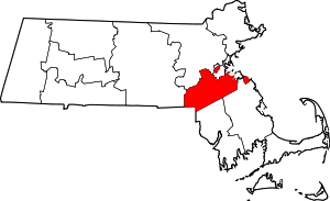 | |
| Towns | ||
| CDPs |
| |
| Other villages | ||
| Authority control |
|
|---|