Woodstock, New Hampshire
Woodstock is a town in Grafton County, New Hampshire, United States. The population was 1,374 at the 2010 census.[1] Woodstock includes the village of North Woodstock, the commercial center. Its extensive land area is largely forested, and includes the Hubbard Brook Experimental Forest. Parts of the White Mountain National Forest are in the east and west. The Appalachian Trail crosses the town's northwest corner. Russell Pond Campground is in the east. West of North Woodstock is the Lost River Reservation.
Woodstock, New Hampshire | |
|---|---|
Town | |
 | |
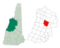 Location in Grafton County, New Hampshire | |
| Coordinates: 43°58′40″N 71°41′09″W | |
| Country | United States |
| State | New Hampshire |
| County | Grafton |
| Incorporated | 1763 |
| Villages | Woodstock North Woodstock |
| Government | |
| • Board of Selectmen | R. Gil Rand, Chair Joel Bourassa Scott Rice |
| Area | |
| • Total | 59.2 sq mi (153.4 km2) |
| • Land | 58.7 sq mi (152.1 km2) |
| • Water | 0.5 sq mi (1.3 km2) 0.84% |
| Elevation | 741 ft (226 m) |
| Population (2010) | |
| • Total | 1,374 |
| • Density | 23/sq mi (9.0/km2) |
| Time zone | UTC-5 (Eastern) |
| • Summer (DST) | UTC-4 (Eastern) |
| ZIP codes | |
| Area code(s) | 603 |
| FIPS code | 33-87060 |
| GNIS feature ID | 0873761 |
| Website | www |
History
First granted in 1763, Colonial Governor Benning Wentworth named the town Peeling after an English town. Many of the first colonists were originally from Lebanon, Connecticut. In 1771, his nephew, Governor John Wentworth, gave it the name Fairfield, after Fairfield, Connecticut. The town was renamed Woodstock in 1840 for Blenheim Palace in Woodstock, England.[2]
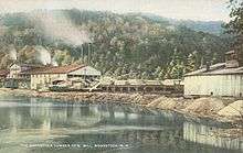
Logging became a principal early industry, with sawmills established using water power from the Pemigewasset River. The entrance of the railroad in the 19th century opened the wilderness to development, carrying away wood products to market. It also brought tourists, many attracted by paintings of the White Mountains by White Mountain artists. Several inns and hotels were built to accommodate the wealthy, who sought relief from the summer heat, humidity and pollution of coal-age Boston, Hartford, New York and Philadelphia. They often relaxed by taking carriage rides through the White Mountains, or by hiking along the Lost River in Lost River Reservation. But with the advent of automobiles, patrons were no longer restricted by the limits of rail service. Consequently, many grand hotels established near depots declined and closed. Woodstock, however, remains a popular tourist destination.
The Hubbard Brook Experimental Forest, an outdoor laboratory for ecological studies founded by the United States Forest Service in 1955, is located in the southern part of town.
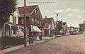 Street scene c. 1910
 Lost River c. 1908
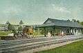 Deer Park Hotel c. 1908
 Main Street in 1916
Geography
According to the United States Census Bureau, the town has a total area of 59.2 square miles (153 km2), of which 58.7 sq mi (152 km2) is land and 0.5 sq mi (1.3 km2) is water, comprising 0.84% of the town. Woodstock is drained by the Pemigewasset River. The town's highest point is the summit of Mount Jim, at 4,172 feet (1,272 m) above sea level, a spur of Mount Moosilauke.
Woodstock is crossed by Interstate 93, U.S. Route 3, New Hampshire Route 112 and New Hampshire Route 175.
Demographics
| Historical population | |||
|---|---|---|---|
| Census | Pop. | %± | |
| 1840 | 472 | — | |
| 1850 | 418 | −11.4% | |
| 1860 | 476 | 13.9% | |
| 1870 | 405 | −14.9% | |
| 1880 | 367 | −9.4% | |
| 1890 | 341 | −7.1% | |
| 1900 | 628 | 84.2% | |
| 1910 | 1,083 | 72.5% | |
| 1920 | 684 | −36.8% | |
| 1930 | 756 | 10.5% | |
| 1940 | 981 | 29.8% | |
| 1950 | 894 | −8.9% | |
| 1960 | 827 | −7.5% | |
| 1970 | 897 | 8.5% | |
| 1980 | 1,008 | 12.4% | |
| 1990 | 1,167 | 15.8% | |
| 2000 | 1,139 | −2.4% | |
| 2010 | 1,374 | 20.6% | |
| Est. 2017 | 1,363 | [3] | −0.8% |
| U.S. Decennial Census[4] | |||

As of the census of 2010, there were 1,374 people, 624 households, and 353 families residing in the town. There were 1,421 housing units, of which 797, or 56.1%, were vacant. 701 of the vacant units were for seasonal or recreational use. The racial makeup of the town was 96.9% White, 0.1% African American, 0.2% Native American, 0.9% Asian, 0.1% Native Hawaiian or Pacific Islander, 0.1% some other race, and 1.8% from two or more races. 0.3% of the population were Hispanic or Latino of any race.[5]
Of the 624 households, 25.5% had children under the age of 18 living with them, 43.6% were headed by married couples living together, 8.5% had a female householder with no husband present, and 43.4% were non-families. 31.6% of all households were made up of individuals, and 9.2% were someone living alone who was 65 years of age or older. The average household size was 2.20, and the average family size was 2.77.[5]
In the town, 19.2% of the population were under the age of 18, 7.9% were from 18 to 24, 24.2% from 25 to 44, 32.2% from 45 to 64, and 16.4% were 65 years of age or older. The median age was 44.2 years. For every 100 females, there were 102.1 males. For every 100 females age 18 and over, there were 101.5 males.[5]
For the period 2011-2015, the estimated median annual income for a household was $49,063, and the median income for a family was $62,500. Male full-time workers had a median income of $33,750 versus $44,034 for females. The per capita income for the town was $30,671. 8.0% of the population and 2.4% of families were below the poverty line. 7.5% of the population under the age of 18 and 5.0% of those 65 or older were living in poverty.[6]
References
- United States Census Bureau, U.S. Census website, 2010 Census figures. Retrieved March 23, 2011.
- Coolidge, Austin J.; John B. Mansfield (1859). A History and Description of New England. Boston, Massachusetts. pp. 702–703.
- "Annual Estimates of the Resident Population: April 1, 2010 to July 1, 2017 (PEPANNRES): Minor Civil Divisions – New Hampshire". Archived from the original on February 13, 2020. Retrieved November 14, 2018.
- "Census of Population and Housing". Census.gov. Retrieved June 4, 2016.
- "Profile of General Population and Housing Characteristics: 2010 Census Summary File 1 (DP-1): Woodstock town, Grafton County, New Hampshire". American Factfinder. U.S. Census Bureau. Archived from the original on February 13, 2020. Retrieved October 31, 2017.
- "Selected Economic Characteristics: 2011-2015 American Community Survey 5-Year Estimates (DP03): Woodstock town, Grafton County, New Hampshire". American Factfinder. U.S. Census Bureau. Archived from the original on February 13, 2020. Retrieved October 31, 2017.
External links
- Town of Woodstock official website
- Moosilauke Public Library
- White Mountain Snowmobile Club
- New Hampshire Economic and Labor Market Information Bureau Profile
Places adjacent to Woodstock, New Hampshire | |
|---|---|
Municipalities and communities of Grafton County, New Hampshire, United States | ||
|---|---|---|
| City | 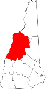 Map of New Hampshire highlighting Grafton County | |
| Towns |
| |
| Township | ||
| CDPs | ||
| Other villages | ||