Chelmsford, Massachusetts
Chelmsford /ˈtʃɛlmsfərd/ is a town in Middlesex County, Massachusetts in the United States. As of the 2010 United States Census, the town's population was 33,802. Only 48.4% are male and the median age of residents in Chelmsford is 39.2 years old. It is located 24 miles (39 km) northwest of Boston and, bordering on the city of Lowell, is part of the Greater Lowell metropolitan area. Besides Lowell on its northeast, Chelmsford is surrounded by four towns: Tyngsborough to the north, Billerica to the southeast, Carlisle to the south, and Westford to the west. Chelmsford is bordered by two sizable rivers: the Merrimack River to the north, and the Concord River to the east.
Town of Chelmsford | |
|---|---|
 First Parish Church | |
 Seal | |
| Motto(s): Let the children guard what the sires have won. | |
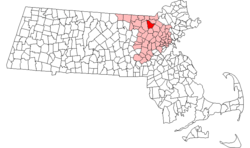 Location in Middlesex County in Massachusetts | |
| Coordinates: 42°35′59″N 71°22′04″W | |
| Country | |
| State | |
| County | Middlesex |
| Region | New England |
| Settled | 1652 |
| Incorporated | 1655 |
| Named for | Chelmsford, Essex |
| Government | |
| • Type | Representative town meeting |
| • Board of Selectmen |
|
| Area | |
| • Total | 60.0 km2 (23.2 sq mi) |
| • Land | 58.7 km2 (22.7 sq mi) |
| • Water | 1.4 km2 (0.5 sq mi) |
| Elevation | 75 m (246 ft) |
| Population (2010) | |
| • Total | 33,802 |
| • Density | 560/km2 (1,500/sq mi) |
| Time zone | UTC−5 (Eastern) |
| • Summer (DST) | UTC−4 (Eastern) |
| ZIP Codes | 01824, 01863 |
| Area code(s) | 351/978 |
| FIPS code | 25-13135 |
| GNIS feature ID | 0618220 |
| Website | www.townofchelmsford.us |
Named after Chelmsford, Essex, England, the town was incorporated in May 1655 by an act of the Massachusetts General Court. When Chelmsford was incorporated, its local economy was fueled by lumber mills, limestone quarries and kilns. The farming community of East Chelmsford was incorporated as Lowell in the 1820s; over the next decades it would go on to become one of the first large-scale factory towns in the United States because of its early role in the country's Industrial Revolution. Chelmsford experienced a drastic increase in population between 1950 and 1970, coinciding with the connection of U.S. Route 3 in Lowell to Massachusetts Route 128 in the 1950s and the extension of U.S. Route 3 from Chelmsford to New Hampshire in the 1960s.
Chelmsford has a representative town meeting form of government. The current town manager is Paul Cohen. The town has one public high school – Chelmsford High School, which is ranked[1] among the top 500 schools in the nation – as well as two middle schools, and four elementary schools. The charter middle school started in Chelmsford became a regional charter school (Innovation Academy Charter School) covering grades 5 through 12, now located in Tyngsborough. Chelmsford high school age students also have the option of attending the Nashoba Valley Technical High School, located in Westford. In 2011, Chelmsford was declared the 28th best place to live in the United States by Money magazine.[2]
History
Settlers from the adjacent communities of Woburn and Concord founded Chelmsford. An act of the Massachusetts General Court in the last week of May 1655 town incorporated Chelmsford, and it was named after Chelmsford, England. The nearby communities of Groton and Billerica were incorporated at the same time. Chelmsford originally contained the neighboring town of Westford, and parts of Carlisle, Tyngsborough, and a large part of Lowell (formerly known as East Chelmsford). Both the Middlesex Canal and Middlesex Turnpike, major transportation routes, were built through Chelmsford in the first part of the 19th century.
The Chelmsford militia played a role in the American Revolution at the Battle of Lexington and Concord and the Battle of Bunker Hill. The town's own Lieutenant Colonel Moses Parker fought on the hill. He was wounded and captured, and died from his wounds on July 4, 1775. The Lieutenant Colonel Moses Parker Middle School honors his name, and the lobby displays a representation of the man. He is depicted in the John Trumbull painting The Death of General Warren at the Battle of Bunker's Hill, June 17, 1775 and in a painting in the Bunker Hill Museum. Captain Benjamin Walker of this town was also killed in this battle.
Ralph Waldo Emerson opened a school in Chelmsford in 1825, closing it after a few months to take over his brother's school in Roxbury.[3]
Chelmsford was the birthplace of the Chelmsford Spring Co. in 1901, which later became the Chelmsford Ginger Ale Company, acquired by Canada Dry in 1928. The ginger ale plant, rebuilt in 1912 after a disastrous fire consumed the original plant, stood on Route 110 until its demolition in 1994. The Chelmsford brand of golden ginger ale continued to be manufactured by Canada Dry for decades. It is currently manufactured by Polar Beverages for DeMoulas/Market Basket supermarkets, based out of neighboring Tewksbury.[4]
Geography
| Chelmsford, Massachusetts | ||||||||||||||||||||||||||||||||||||||||||||||||||||||||||||
|---|---|---|---|---|---|---|---|---|---|---|---|---|---|---|---|---|---|---|---|---|---|---|---|---|---|---|---|---|---|---|---|---|---|---|---|---|---|---|---|---|---|---|---|---|---|---|---|---|---|---|---|---|---|---|---|---|---|---|---|---|
| Climate chart (explanation) | ||||||||||||||||||||||||||||||||||||||||||||||||||||||||||||
| ||||||||||||||||||||||||||||||||||||||||||||||||||||||||||||
| ||||||||||||||||||||||||||||||||||||||||||||||||||||||||||||
According to the United States Census Bureau, the town has a total area of 23.2 square miles (60 km2), of which 22.6 square miles (59 km2) is land and 0.5 square miles (1.3 km2), or 2.29%, is water. Chelmsford is bordered by two sizable rivers: the Merrimack River to the north, and the Concord River to the east.
Chelmsford consists of several neighborhoods. In addition to the town center, smaller areas include South Chelmsford, West Chelmsford, East Chelmsford, North Chelmsford and The Westlands. North Chelmsford, an industrial village, is distinct from the rest of the town to the extent that it has many of its own town services. The northern parts of Chelmsford tend to be more urban and densely populated, while the south is generally more rural.
Like much of the rest of Massachusetts, Chelmsford has a humid continental climate according to the Köppen climate classification. Summers are typically warm and humid, while winters tend to be cold, windy, and snowy. The level of precipitation is roughly consistent throughout the year.[5]
Demographics
| Historical population | ||
|---|---|---|
| Year | Pop. | ±% |
| 1850 | 2,097 | — |
| 1860 | 2,291 | +9.3% |
| 1870 | 2,374 | +3.6% |
| 1880 | 2,553 | +7.5% |
| 1890 | 2,695 | +5.6% |
| 1900 | 3,984 | +47.8% |
| 1910 | 5,010 | +25.8% |
| 1920 | 5,682 | +13.4% |
| 1930 | 7,022 | +23.6% |
| 1940 | 8,077 | +15.0% |
| 1950 | 9,407 | +16.5% |
| 1960 | 15,130 | +60.8% |
| 1970 | 31,432 | +107.7% |
| 1980 | 31,174 | −0.8% |
| 1990 | 32,383 | +3.9% |
| 2000 | 33,858 | +4.6% |
| 2010 | 33,802 | −0.2% |
| * = population estimate. Source: United States Census records and Population Estimates Program data.[6][7][8][9][10][11][12][13][14][15] | ||
As of the US census of 2010,[16] there were 33,802 people, 13,313 households, and 9,328 families residing in the town. The racial makeup of the town was 88.6% White, 1.1% African American, 0.1% Native American, 8.4% Asian, 0.4% from other races, and 1.4% from two or more races. Hispanic or Latino of any race were 2% of the population.
Crime
As of 2008, Chelmsford had a violent crime rate of 132 incidents per 100,000 people,[17] compared to a rate of 449 in Massachusetts as a whole and 455 nationwide.[18][19][20] The town had a property crime rate of 1,904 incidents per 100,000 people in 2008,[17] compared to a rate of 2,400 for the state and 3,213 nationwide.[19][20] Chelmsford has one police station located near McCarthy Middle School. The 25,000 square feet (2,300 m2), $7.19-million dollar structure began operation in 2003.[21]
Government
The town uses a representative town meeting model with a Board of Selectmen overseeing the operation of the town. As of May 2020, the members of the Board of Selectmen are: Chairman Kenneth LeFebvre, Vice Chairman Pat Wotjas, Clerk Emily R. Antul, George R. Dixon, Jr. and Virginia Crocker Timmins.[22] Reporting to the Board of Selectmen are the town manager, town counsel, and town accountant. The town manager oversees the public employees and serves as Chief Executive Officer. The current town manager is Paul Cohen. Other elected boards include the Planning Board, School Committee, Library Trustees, Cemetery Commission, Board of Health, Sewer Commission and the Zoning Board of Appeals.[23]
As of 2020 Chelmsford is represented in the Massachusetts Senate by Michael J. Barrett.[24][25] The town sends four delegates to the Massachusetts House of Representatives, each of whom represent one or more of Chelmsford's nine precincts.[24] Tami Gouveia is the state representative for precincts one and nine; Thomas Golden Jr., precincts two, six and eight; James Arciero, precincts three, five and seven; and David Nangle, precinct four.[24]
The Fay A. Rotenberg School, a juvenile correctional facility for girls operated by the Robert F. Kennedy Children’s Action Corps, Inc. on behalf of the Massachusetts Department of Youth Services, first opened in North Chelmsford in 1982; this facility had 16 beds.[26] In 2006 the school moved to its current location in Westborough.[27]
Education
The Chelmsford public schools district serves students in pre-Kindergarten through twelfth grade. According to data for 2008–09 from the Massachusetts Department of Elementary and Secondary Education (ESE),[28] schools in the district include the Charles D. Harrington school serving 586 students in pre-Kindergarten through grade four. There are three other elementary schools serving Kindergarten through fourth grade: Byam Elementary School, with 536 students; Center Elementary School, with 521 students; and South Row, with 473 students. Westlands Elementary School, which had been serving Kindergarten through fourth grade, with 366 students as of the 2007–08 school year,[29] was closed in 2008 due to budget cuts but repurposed as the home building for Chelmsford Community Education and the Chelmsford Integrated Preschool ("CHIPS")., and North School burned down in 1981. Chelmsford has two middle schools, serving grades five through eight: Colonel Moses Parker Middle School, with 757 students; and McCarthy Middle School, with 947 students. The town contains one high school, Chelmsford High School, serving grades nine through twelve to 1,641 students as of 2008–09.[28] The town also had one public charter school, Innovation Academy, serving 400 students in grades five through ten. As of September 2008, Innovation Academy moved to the town of Tyngsborough, currently serving grades five through twelve.[30] Past schools, the buildings of which are either no longer existing or have been repurposed, include: -the first Chelmsford High School (now Town Hall) -North School (burned down in 1981, Chelmsford Senior Center built on the property) -Quessy School (no longer standing) -Highland School (interior rebuilt as residential) -McFarlane School (interior rebuilt as residential for the elderly) -East School (building in use as a commercial property)
All expenditures considered, the Chelmsford public schools district spent $10,070 per pupil as of 2008, which was lower than the state average of $12,449. This was an increase of almost $400 from Chelmsford per-pupil spending in 2007. As of 2008 per-pupil allocation, $3,937 went to classroom and specialist teachers, $333 to administration, and $185 to instructional materials, equipment and technology.[31]
In 2009, Chelmsford High School ranked 66th out of 150 public high schools considered by Boston Magazine. The ranking took into account many statistics associated with quality of education and academic performance, including the school's 14.5:1 student–teacher ratio.[32] In the 2006–2007 school year, the average SAT scores for Chelmsford High School were 527 in the reading section, 519 in writing, and 535 in math.[33] Chelmsford High School performed significantly better than the state average in the English, math and science portions of the 2009 Grade 10 MCAS tests, scoring 89, 87 and 77 out of 100, respectively.[34]
Historic places in Chelmsford
- Chelmsford Center Historic District
- Fiske House (1798)
- Hildreth-Robbins House (1742)
- Middlesex Canal (1802)
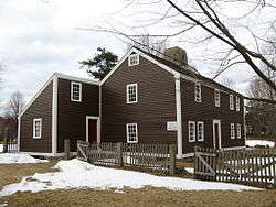
- Old Chelmsford Garrison House (1691), now a museum
- Oliver Hutchins House (1820)
- Barrett-Byam Homestead (1663)-home of the Chelmsford Historical Society
- North Town Hall (1853)
- House Of Taigen Charter school (1834)
Transportation
Chelmsford is located at the intersection of the major US highways of I-495 and Route 3. Also found in Chelmsford are state routes 3A, 4, 27, 40, 110, and 129.
Chelmsford Center is a notorious junction of roadways. The heart of the town center is Central Square - the junction of routes 4, 110, the end of 129, and Westford Street. The Square is affectionately known as 'Chicken Corner' to locals. Until the 21st century, lights there were seen as non-'historic', crossing the 1 acre (0.40 ha) of pavement with no controls save a few stop signs was akin to a game of Chicken. Drivers would wait in long lines of cars to enter the square, where they often would invent their own lanes, waiting for a relatively safe chance to cross. In 2004, the town was forced to put in stoplights and lane markers. They were necessary to control the traffic-clogged center. In addition to the Square, Chelmsford Center is a series of merging and splitting roads, many one-way, including the beginning of route 27.
Chelmsford is home to the former Drum Hill Rotary. This rotary was the cause of many accidents that occurred due to its small overall size and ability for vehicles to gain speed. It formed the intersection of U.S. Route 3 (exit 32), Route 4, Drum Hill Road, and Westford Road. The rotary was demolished in 2003. It was replaced with a four intersection square with traffic lights, and is now called Drum Hill Square. This was part of a widening project for U.S. Route 3 between Interstate 95 (Route 128) and the New Hampshire state line.
Freight travels daily through Chelmsford over the tracks of the historic Stony Brook Railroad. The line currently serves as a major corridor of Pan Am Railway's District 3 which connects New Hampshire and Maine with western Massachusetts, Vermont, and New York.[35]
The Bruce Freeman Rail Trail runs 6.8 miles (10.9 km) through Chelmsford, including the Central Square intersection.
The LRTA bus routes 15, 16 and 17 connect Chelmsford to the Lowell train station on the MBTA Commuter Rail Lowell Line.
North Chelmsford will get a Massachusetts Bay Transportation Authority commuter rail station if the proposed extension of the Lowell Line to Nashua, New Hampshire is completed.
Notable people
- Josiah Gardner Abbott (1814–1891), born in Chelmsford, member of the United States House of Representatives, the Massachusetts House of Representatives and the Massachusetts Senate[36]
- Keith Aucoin, former NHL player
- Phil Bourque, NHL veteran, two Stanley Cups with the Pittsburgh Penguins
- Gerry Callahan, popular albeit controversial Boston Herald and former Sports Illustrated sports columnist and co-host of WEEI-FM's Dennis and Callahan, the popular sports radio morning program based in Boston. Played on Chelmsford High School's first ever "Super Bowl" team in 1978. Many consider him the reason Chelmsford lost the game for he drew a penalty on a touchdown play resulting in Chelmsford High School's loss. This play led to the nickname Gerry "The Clipper" Callahan, which people often call up and mention on his radio show.
- George Condo, Chelmsford High School graduate. Painter who has exhibited at the New Museum and the Whitney Museum Biennial. His artwork can also be found on the cover of Kanye West's 2011 album, My Beautiful Dark Twisted Fantasy. He formerly worked as a printer for Andy Warhol.[37]
- Bill Cooke, pro football player
- Dan Curran, former fullback/linebacker for the Arena Football League's New Orleans VooDoo and National Football League (2001–2009)
- Edward DeSaulnier, state legislator and judge.[38]
- Gururaj Deshpande, social entrepreneur, co-founder of Sycamore Networks, Deshpande Center for Technological Innovation at MIT
- Steve Hunt, jazz pianist who recorded and toured with Allan Holdsworth, Stanley Clarke, and Billy Cobham; teaches at Berklee College of Music
- Ulysses John "Tony" Lupien, Major League Baseball player and the baseball coach at Dartmouth College for 21 seasons, born in Chelmsford in 1917
- Jon Morris, NHL veteran, New Jersey Devils
- Benjamin Pierce, Governor of New Hampshire and the father of U.S. president Franklin Pierce, born in Chelmsford in 1757
- Peter Torkildsen, chairman of the Massachusetts Republican Party and former two-term Congressman in Massachusetts' 6th District, from 1993 to 1997
- John Traphagan, author, professor of Religious Studies and Anthropology, and former director of the Center for East Asian Studies, University of Texas at Austin
- Kristen Wilson, actress appearing in several films, television shows and plays, including the national tour of West Side Story
- Lance Wilder, background design supervisor for The Simpsons, 1986 Chelmsford High School graduate. The elementary school appearing in The Simpsons is based on McCarthy Middle School, which was Chelmsford's high school before the construction of the current Chelmsford High School in 1974. The town hall in the show is based on the Chelmsford Public Library (prior to the recent reconstruction). Many other local businesses and stores in Chelmsford find their way into the background in The Simpsons' hometown of Springfield, including Zesty Pizza, and the now defunct, Skip's Restaurant, Skip's Ice Cream, Tony and Ann's Pizza, and Jack's Diner.
- Jeffrey Snover, Microsoft Technical Fellow and inventor of PowerShell.
- Liz McCartney, broadway actress
- Sandra Newman, Writer
- Jack Eichel, Current NHL player, Buffalo Sabres
- Colleen Mullen, Current Head Coach, University of Albany Women's Basketball and Chelmsford High School graduate
- Charlie Noyes, current president of the 99 Restaurant & Pub, headquartered in Woburn, Ma.
See also
References
- "America's Top High Schools". Newsweek. Newsweek LLC. September 2, 2015. Retrieved September 15, 2015.
- Ashford, Kate; Bartz, Andrea; Cox, Jeff; Fitch, Asa; Gandel, Stephen; Hyatt, Josh; Kelley, Rob; Knight, Kathleen; et al. (2011). "Best Places to Live: Top 100". CNN Money. Retrieved June 25, 2012.
- "Emerson Chronology". Ralph Waldo Emerson Society. March 13, 2008. Archived from the original on March 30, 2010. Retrieved January 10, 2010.
- "A taste of the town's history". GateHouse Media. July 24, 2008. Archived from the original on July 29, 2013. Retrieved March 15, 2012.
- "Monthly averages and records". MSN. 2010. Archived from the original on March 18, 2009. Retrieved January 25, 2010.
- "Total Population (P1), 2010 Census Summary File 1". American FactFinder, All County Subdivisions within Massachusetts. United States Census Bureau. 2010.
- "Massachusetts by Place and County Subdivision - GCT-T1. Population Estimates". United States Census Bureau. Retrieved July 12, 2011.
- "1990 Census of Population, General Population Characteristics: Massachusetts" (PDF). US Census Bureau. December 1990. Table 76: General Characteristics of Persons, Households, and Families: 1990. 1990 CP-1-23. Retrieved July 12, 2011.
- "1980 Census of the Population, Number of Inhabitants: Massachusetts" (PDF). US Census Bureau. December 1981. Table 4. Populations of County Subdivisions: 1960 to 1980. PC80-1-A23. Retrieved July 12, 2011.
- "1950 Census of Population" (PDF). Bureau of the Census. 1952. Section 6, Pages 21-10 and 21-11, Massachusetts Table 6. Population of Counties by Minor Civil Divisions: 1930 to 1950. Retrieved July 12, 2011.
- "1920 Census of Population" (PDF). Bureau of the Census. Number of Inhabitants, by Counties and Minor Civil Divisions. Pages 21-5 through 21-7. Massachusetts Table 2. Population of Counties by Minor Civil Divisions: 1920, 1910, and 1920. Retrieved July 12, 2011.
- "1890 Census of the Population" (PDF). Department of the Interior, Census Office. Pages 179 through 182. Massachusetts Table 5. Population of States and Territories by Minor Civil Divisions: 1880 and 1890. Retrieved July 12, 2011.
- "1870 Census of the Population" (PDF). Department of the Interior, Census Office. 1872. Pages 217 through 220. Table IX. Population of Minor Civil Divisions, &c. Massachusetts. Retrieved July 12, 2011.
- "1860 Census" (PDF). Department of the Interior, Census Office. 1864. Pages 220 through 226. State of Massachusetts Table No. 3. Populations of Cities, Towns, &c. Retrieved July 12, 2011.
- "1850 Census" (PDF). Department of the Interior, Census Office. 1854. Pages 338 through 393. Populations of Cities, Towns, &c. Retrieved July 12, 2011.
- "U.S. Census website". United States Census Bureau. Retrieved 2008-01-31.
- "Massachusetts: Offenses Known to Law Enforcement by State by City, 2008". US Federal Bureau of Investigation. Archived from the original on September 23, 2009. Retrieved January 31, 2010.
- Penman, Shelley (July 2009). "Violent Crime in Massachusetts" (PDF). Massachusetts Executive Office of Public Safety and Security. Retrieved January 31, 2010.
- "Crime in the United States by State, 2008". US Federal Bureau of Investigation. September 2009. Archived from the original on January 29, 2010. Retrieved January 31, 2010.
- "Crime in the United States by Volume and Rate per 100,000 Inhabitants, 1989–2008". US Federal Bureau of Investigation. September 2009. Archived from the original on January 23, 2010. Retrieved January 31, 2010.
- Spoth, Tom (April 15, 2003). "Chelmsford station to open April 22 knock wood". The Sun. Retrieved January 31, 2010.
- "Elected Officials, Board of Selectmen". Town of Chelmsford. Retrieved May 5, 2020.
- "Elected Officials". Town of Chelmsford. January 25, 2010. Archived from the original on January 3, 2010. Retrieved January 25, 2010.
- "State Legislators". Town of Chelmsford. Archived from the original on December 11, 2010. Retrieved January 25, 2010.
- "About Senator Susan Fargo". Commonwealth of Massachusetts. Retrieved January 25, 2010.
- "Fay A. Rotenberg School North Chelmsford, Massachusetts" (). Robert F. Kennedy Children's Action Corps. December 30, 2006. Retrieved on December 24, 2015.
- "Celebrating 30 Years of Service to Young Women" (Archive). Robert F. Kennedy Children's Action Corps. January 12, 2012. Retrieved on December 24, 2015.
- "Student Data, Chelmsford: Enrollment by Grade". Massachusetts Department of Elementary and Secondary Education. Retrieved January 31, 2010.
- "Search for Public Schools: Chelmsford". National Center for Education Statistics. Retrieved January 28, 2010.
- "About us". "Innovation Academy Charter School". Archived from the original on July 27, 2011. Retrieved January 28, 2010.
- "General Data, Chelmsford: Total Expenditure Per Pupil, All Funds, By Function". Massachusetts Department of Elementary and Secondary Education. Retrieved January 31, 2010.
- Recck, George. "Public Schools Chart". Boston Magazine. Archived from the original on July 8, 2010. Retrieved January 31, 2010.
- "2006-07 SAT Report". Massachusetts Department of Elementary and Secondary Education. Retrieved January 31, 2010.
- "Top-scoring districts on the 2009 Grade 10 MCAS exams". Boston Globe. September 14, 2009. Retrieved January 31, 2010.
- Pan Am Railways route map.panamrailways.com. Accessed August 31, 2007.
- Who Was Who in America, Historical Volume, 1607-1896. Marquis Who's Who. 1967.
- "Portraits of Imaginary People: How George Condo reclaimed Old Master painting". The New Yorker. January 17, 2011. Retrieved March 30, 2011.
- https://www.newspapers.com/image/439124584/
Further reading
- 1871 Atlas of Massachusetts. by Wall & Gray. Map of Massachusetts. Map of Middlesex County.
- History of Chelmsford, Massachusetts, by Wilson Waters, Henry Spaulding Perham, published 1917, 893 pages.
Two versions of History of Chelmsford, Massachusetts are online: Page images and HTML - History of Middlesex County, Massachusetts, Volume 1 (A-H), Volume 2 (L-W) compiled by Samuel Adams Drake, published 1879-1880. 572 and 505 pages. Chelmsford article by Frederick P. Hill in volume 1 page 367-380.
- Money Magazine - Top 100 Places to Live
External links
| Wikimedia Commons has media related to Chelmsford, Massachusetts. |
Municipalities and communities of Middlesex County, Massachusetts, United States | ||
|---|---|---|
| Cities | 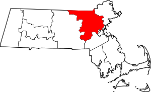 | |
| Towns |
| |
| CDPs | ||
| Other villages |
| |
| Authority control |
|
|---|