Tilton, New Hampshire
Tilton is a town on the Winnipesaukee River in Belknap County, New Hampshire, United States. The population was 3,567 at the 2010 census.[1] It includes the village of Lochmere. Tilton is home to the Tilton School, a private preparatory school.
Tilton, New Hampshire | |
|---|---|
Town | |
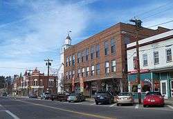 Downtown Tilton | |
 Seal | |
 Location in Belknap County, New Hampshire | |
| Coordinates: 43°26′32″N 71°35′22″W | |
| Country | United States |
| State | New Hampshire |
| County | Belknap |
| Incorporated | 1869 |
| Villages | Tilton Lochmere Winnisquam |
| Government | |
| • Board of Selectmen | Jonathan Scanlon, Chair Katherine Dawson Patricia Consentino Joseph Jesseman Peter Fogg |
| • Town Administrator | Jeanie Forrester |
| Area | |
| • Total | 12.0 sq mi (31.1 km2) |
| • Land | 11.1 sq mi (28.8 km2) |
| • Water | 0.8 sq mi (2.2 km2) 7.12% |
| Elevation | 443 ft (135 m) |
| Population (2010) | |
| • Total | 3,567 |
| • Density | 320/sq mi (123.7/km2) |
| Time zone | UTC-5 (Eastern) |
| • Summer (DST) | UTC-4 (Eastern) |
| ZIP codes | 03276, 03298, 03299 |
| Area code(s) | 603 |
| FIPS code | 33-77060 |
| GNIS feature ID | 0873739 |
| Website | www |
History
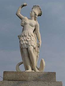
Originally the southern part of Sanbornton, the present area of Tilton was known as Sanbornton Bridge and Bridge Village.[2] These two names refer to the bridge, built in 1763, that crossed the Winnipesaukee River from Canterbury to Sanbornton and onto what is now Main Street in Tilton.[3] In 1869, Sanbornton Bridge was set off and incorporated as Tilton, named in honor of Nathaniel Tilton, whose grandson Charles E. Tilton was the owner of textile mills and the community's wealthiest citizen. Nathaniel Tilton established an iron foundry and the area's first hotel, the Dexter House. Charles E. Tilton donated many statues to the town, a unique feature, and his estate is now part of the Tilton School. Tilton Hall, his former mansion built in 1861, houses the Lucian Hunt Library. The attached carriage house was renovated in 1980 to become the Helene Grant Daly Art Center.
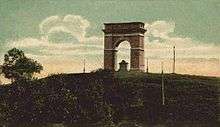
Charles E. Tilton also donated what is perhaps the most notable landmark in the area, the hilltop Memorial Arch, located in the neighboring town of Northfield, across the Winnipesaukee River from the center of Tilton. The Roman arch replica was built in the late 1800s as a memorial to his ancestors. It is built of Concord granite, 50 feet (15 m) high and 40 feet (12 m) wide.
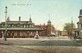 Main Street in 1909
 Tilton Island Park c. 1908
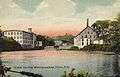 View of the mills in 1908
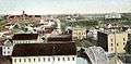 View from Arch Hill in 1906
Geography
According to the United States Census Bureau, the town has a total area of 12.0 square miles (31.1 km2), of which 11.1 square miles (28.8 km2) is land and 0.85 square miles (2.2 km2) is water, comprising 7.12% of the town.[4] Tilton is drained by the Winnipesaukee River. It is bounded in the east by Silver and Winnisquam lakes.
The highest point in Tilton is 866 feet (264 m) above sea level, along the town's northern border, near the summit of Calef Hill.
Tilton is served by Interstate 93, U.S. Route 3, and state routes 11, 132 and 140. Tilton is considered the gateway to the Lakes Region of the state, and a large commercial and retail district has sprung up at the intersection of the five aforementioned routes, just off Exit 20 of I-93. The historic village of Tilton is located a short distance to the west of the new commercial development, on the northern banks of the Winnipesaukee.
Adjacent municipalities
- Sanbornton (north)
- Belmont (east)
- Northfield (south)
- Franklin (west)
Demographics
| Historical population | |||
|---|---|---|---|
| Census | Pop. | %± | |
| 1870 | 1,147 | — | |
| 1880 | 1,232 | 7.4% | |
| 1890 | 1,521 | 23.5% | |
| 1900 | 1,926 | 26.6% | |
| 1910 | 1,866 | −3.1% | |
| 1920 | 2,014 | 7.9% | |
| 1930 | 1,712 | −15.0% | |
| 1940 | 1,738 | 1.5% | |
| 1950 | 2,085 | 20.0% | |
| 1960 | 2,137 | 2.5% | |
| 1970 | 2,579 | 20.7% | |
| 1980 | 3,387 | 31.3% | |
| 1990 | 3,240 | −4.3% | |
| 2000 | 3,477 | 7.3% | |
| 2010 | 3,567 | 2.6% | |
| Est. 2017 | 3,555 | [5] | −0.3% |
| U.S. Decennial Census[6] | |||
As of the census of 2010, there were 3,567 people, 1,462 households, and 888 families residing in the town. There were 1,845 housing units, of which 383, or 20.8%, were vacant. 212 of the vacant units were for seasonal or recreational use. The racial makeup of the town was 96.2% white, 0.4% African American, 0.2% Native American, 1.4% Asian, 0.0% Native Hawaiian or Pacific Islander, 0.2% some other race, and 1.7% from two or more races. 1.1% of the population were Hispanic or Latino of any race.[7]
Of the 1,462 households, 25.2% had children under the age of 18 living with them, 46.4% were headed by married couples living together, 9.5% had a female householder with no husband present, and 39.3% were non-families. 30.2% of all households were made up of individuals, and 11.6% were someone living alone who was 65 years of age or older. The average household size was 2.28, and the average family size was 2.83.[7]
In the town, 17.9% of the population were under the age of 18, 7.4% were from 18 to 24, 24.5% from 25 to 44, 30.4% from 45 to 64, and 20.0% were 65 years of age or older. The median age was 45.2 years. For every 100 females, there were 106.2 males. For every 100 females age 18 and over, there were 106.2 males.[7]
For the period 2011-2015, the estimated median annual income for a household was $54,276, and the median income for a family was $59,754. Male full-time workers had a median income of $40,132 versus $36,715 for females. The per capita income for the town was $28,510. 8.3% of the population and 4.6% of families were below the poverty line. 16.6% of the population under the age of 18 and 6.4% of those 65 or older were living in poverty.[8]
Government
In the New Hampshire Senate, Tilton is in the 2nd District, represented by Republican Bob Giuda. On the New Hampshire Executive Council, Tilton is in the 1st District, represented by Democrat Michael J. Cryans. In the United States House of Representatives, Tilton is in New Hampshire's 1st congressional district, represented by Democrat Chris Pappas.
Notable people
- John Charles Daly (1914-1991), television personality, network executive, host of What's My Line?, alumnus of Tilton School
- Mary Baker Eddy (1821–1910), founder of Christian Science
- John W. Gowdy (1869–1963), bishop of the Methodist Episcopal Church and Methodist Church
- Jonathan Page (b. 1976), American champion cyclocross racer
- Harry Taylor (1862–1930), US Army major general and USACE Chief of Engineer
Sites of interest
- New Hampshire Historical Marker No. 149: Lochmere Archeological District
- New Hampshire Historical Marker No. 262: Charles E. Tilton's Legacy
References
- United States Census Bureau, American FactFinder, 2010 Census figures. Retrieved March 23, 2011.
- Coolidge, Austin J.; John B. Mansfield (1859). A History and Description of New England. Boston, Massachusetts: A.J. Coolidge. pp. 643–644.
coolidge mansfield history description new england 1859.
- Brochure: Tilton-Northfield Historical Walking Tour, Northfield/Tilton Economic Development Corp., PO Box 659, Tilton, NH 03276
- "Geographic Identifiers: 2010 Demographic Profile Data (G001) - Tilton town, New Hampshire". United States Census Bureau. Retrieved November 7, 2011.
- "Annual Estimates of the Resident Population: April 1, 2010 to July 1, 2017 (PEPANNRES): Minor Civil Divisions – New Hampshire". Archived from the original on February 13, 2020. Retrieved November 14, 2018.
- "Census of Population and Housing". Census.gov. Retrieved June 4, 2016.
- "Profile of General Population and Housing Characteristics: 2010 Census Summary File 1 (DP-1): Tilton town, Belknap County, New Hampshire". U.S. Census Bureau, American Factfinder. Archived from the original on February 14, 2020. Retrieved October 25, 2017.
- "Selected Economic Characteristics: 2011-2015 American Community Survey 5-Year Estimates (DP03): Tilton town, Belknap County, New Hampshire". U.S. Census Bureau, American Factfinder. Archived from the original on February 13, 2020. Retrieved October 25, 2017.
External links
- Town of Tilton official website
- Hall Memorial Library
- New Hampshire Economic and Labor Market Information Bureau Profile
- Tilton-Northfield Arch Trail Travelers Snowmobile Club
- Tilton School
Places adjacent to Tilton, New Hampshire | |
|---|---|
Municipalities and communities of Belknap County, New Hampshire, United States | ||
|---|---|---|
| City |  Map of New Hampshire highlighting Belknap County | |
| Towns | ||
| CDPs | ||
| Other villages | ||
| Footnotes | ‡This populated place also has portions in an adjacent county or counties | |
| Authority control |
|
|---|