Belmont, Massachusetts
Belmont is a town in Middlesex County, Massachusetts. It is a western suburb of Boston, Massachusetts, United States; and is part of the greater Boston metropolitan area. Its population was 26,123 as of November 25, 2019.[2]
Belmont, Massachusetts | |
|---|---|
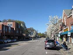 Looking north on Leonard Street in the town center | |
.png) Seal | |
| Motto(s): "The Town Of Homes"[1] | |
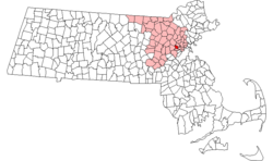 Location in Middlesex County in Massachusetts | |
| Coordinates: 42°23′45″N 71°10′45″W | |
| Country | United States |
| State | Massachusetts |
| County | Middlesex |
| Settled | 1636 |
| Incorporated | 1859 |
| Government | |
| • Type | Representative town meeting |
| Area | |
| • Total | 4.7 sq mi (12.2 km2) |
| • Land | 4.7 sq mi (12.1 km2) |
| • Water | 0.1 sq mi (0.1 km2) |
| Elevation | 44 ft (13 m) |
| Population (2019) | |
| • Total | 26,123 |
| • Density | 5,600/sq mi (2,100/km2) |
| Time zone | UTC-5 (Eastern) |
| • Summer (DST) | UTC-4 (Eastern) |
| ZIP code | 02478 |
| Area code(s) | 617 / 857 |
| FIPS code | 25-05070 |
| GNIS feature ID | 0618216 |
| Website | Town of Belmont, MA |
History
Belmont was established on March 10, 1849, by former citizens of, and land from the bordering towns of Watertown, to the south; Waltham, to the west; and Arlington, then known as West Cambridge, to the north. They also wanted a town where no one could buy or sell alcohol (today, a person can buy alcohol in this town). The town was named after Bellmont, the 200 acre (0.8 km²) estate of the largest donor to its creation, John Perkins Cushing. Cushing Square is named after him and what was left of his estate after it nearly burned to the ground became a Belmont Public Library branch. The easternmost section of the town, including the western portion of Fresh Pond, was annexed by Cambridge in 1890[3] in a dispute over a slaughterhouse licensed in 1878[4] on Fresh Pond, so that Cambridge could protect Fresh Pond, a part of its municipal water system.
Preceding its incorporation, Belmont was an agrarian based town, with several large farms servicing Boston for produce and livestock. It remained largely the same until the turn of the twentieth century, when trolley service and better roads were introduced, making the town more attractive as a residential area, most notably for the building of large estates.
Belmont's population grew by over 70 percent during the 1820s.[5]
The economics of the town shifted from purely agrarian to a commercial greenhouse base; much of the flower and vegetable needs of Boston were met from the Belmont 'hothouses' which persisted until about 1983 when Edgar's, the last large greenhouse firm in the area, closed. Other commercial enterprises in Belmont included mining clay and waste management. The reclamation of a large dump and quarry off Concord Avenue into sites for the Belmont High School and the Clay Pit Pond stands as a lasting example of environmental planning. With the introduction of automobiles and highways, Belmont continued its transition to a commuter-based suburb throughout the twentieth century.
Belmont was the home of the headquarters of the John Birch Society from the organization's founding in 1958 until its relocation to Appleton, Wisconsin in 1989. The building at 395 Concord Avenue later became the headquarters of the National Association for Armenian Studies and Research (NAASR), which is expanding and renovating its facility as of 2019.[6]
Railroad history

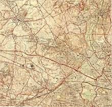
Belmont was once served by two railroads, the Fitchburg Railroad and the Central Massachusetts Railroad, both of which were later to become part of the Boston & Maine Railroad system. Originally the two railroads each had their own separate trackage through town, but in 1952 the Central Mass tracks were removed between Hill's Crossing and Clematis Brook (Waltham),[7] and rail traffic was rerouted over the Fitchburg line.
Today the MBTA owns the trackage that runs through Belmont, which is known as the Fitchburg Line. Passenger service on this line currently terminates at Fitchburg, but it once was the area's main route into New York state. As of 2011, the MBTA was planning to extend future service to West Fitchburg.
The station stops at Belmont Center and Waverley were once grade crossings, so that pedestrian and vehicular traffic had to cross directly over rails that were in public roads. In 1907, the grade at Belmont Center was eliminated by constructing a stone arch bridge and elevated embankment to carry the tracks past a new station building. At Waverley, the grade was lowered so that the tracks ran under Trapelo Road, though the platform did not have an enclosed structure at that location.
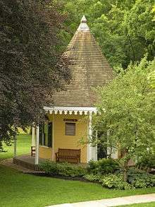
A second historic railroad station building exists in Belmont, though it is not obvious. The one-room Wellington Hill Station was originally built in the 1840s as a private school, not far from its current location in Belmont Center. It was then used by the Fitchburg Railroad from 1852 to 1879. When the railroad decided to replace the station with a larger structure, the building was moved to the Underwood Estate and used as a summer house. In 1974, the station was donated to the Belmont Historical Society. It was restored and relocated to its current location in 1980.
Present day
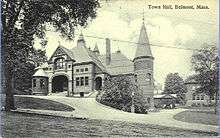
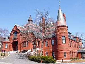
Belmont remains a primarily residential suburb, with little population growth since the 1950s. It is best known for the mansion-filled Belmont Hill neighborhood, although most residents live in more densely settled, low-lying areas around the Hill. There are three major commercial centers in the town: Belmont Center in the center, Cushing Square in the south, and Waverley Square in the west. Town Hall and other civic buildings are located in Belmont Center. Large tracts of land from former farms and greenhouse estates form public or publicly accessible areas such as Rock Meadow, Habitat (Mass Audubon), portions of the McLean Hospital tract and various town fields.
Geography
According to the United States Census Bureau, the town has a total area of 4.7 square miles (12.2 km²), of which 4.7 square miles (12.1 km²) is land and less than 0.1 square miles (0.1 km²), or 1.06%, is water.
Belmont is bordered by Cambridge on the east, Arlington on the north, Lexington on the northwest, Waltham on the west, and Watertown on the south.
Environmental concerns
In 2002, Middlesex County was ranked in the worst 10% of polluted counties in the United States in terms of air and water pollution.[8] Two companies that ranked in the top 10 for polluters in the county were Polaroid Corporation in Waltham and the Cambridge Plating Company in Belmont, which is located several hundred feet from Belmont High School. Now operated by Purecoat North LLC, the Cambridge Plating Company was fined by the Environmental Protection Agency in 2002 following various violations[9] and in 2004 following a fire that led to an accumulation of toxic wastewater.[10]
The chemicals released were trichloroethylene and dichloromethane, both of which are harmful and have been shown to cause cancer. These chemicals are released into the air so it is difficult to trace them and to determine the source as there are also several other industries in the area that release the same pollutants. It is estimated that 3% of homes in Belmont are at risk of having lead hazards.
In 2004, the town of Belmont first hosted an annual community environmental fair to encourage environmentally friendly behavior for its residents.[11]
Demographics
| Historical population | ||
|---|---|---|
| Year | Pop. | ±% |
| 1860 | 1,198 | — |
| 1870 | 1,513 | +26.3% |
| 1880 | 1,615 | +6.7% |
| 1890 | 2,098 | +29.9% |
| 1900 | 3,929 | +87.3% |
| 1910 | 5,542 | +41.1% |
| 1920 | 10,749 | +94.0% |
| 1930 | 21,748 | +102.3% |
| 1940 | 26,867 | +23.5% |
| 1950 | 27,381 | +1.9% |
| 1960 | 28,715 | +4.9% |
| 1970 | 28,285 | −1.5% |
| 1980 | 26,100 | −7.7% |
| 1990 | 24,720 | −5.3% |
| 2000 | 24,194 | −2.1% |
| 2010 | 24,729 | +2.2% |
| 2018 | 26,330 | +6.5% |
| * = population estimate. Source: United States Census records and Population Estimates Program data.[12][13][14][15][16][17][18][19][20] | ||
As of 2019, there were 26,123 residents of the Town of Belmont with 17,605 registered voters. The 2010 census lists 10,184 housing units. The population density was 5,316.9 people per square mile (2,004.6/km²). The racial make up of the town was 76.9% White, 1.8% Black or African American, 0.1% Native American, 14.1% Asian, and 2.7% from two or more races. Hispanic or Latino of any race were 4.9% of the population. 6.3% of the population are under the age of five, 24.6% are under the age of eighteen, and 15.8% are 65 years of age or older; 53% are female. The median household income was $114,141.[21]
The 2000 census listed 9,732 households out of which 31.0% had children under the age of 18 living with them, 54.9% were married couples living together, 8.8% had a female householder with no husband present, and 33.7% were non-families. 25.9% of all households were made up of individuals and 11.9% had someone living alone who was 65 years of age or older. The average household size was 2.45 and the average family size was 3.01.
In 2010, 20% of the residents of Belmont were born outside of the United States. In 2000 this percentage was 15%.[22]
Belmont has been referred to as a "Mormon enclave"[23] due to the location of the Boston Massachusetts Temple of the LDS Church at the highest elevation in the town. The prominent gold statue of the Angel Moroni atop the Temple was originally designed by Cyrus Dallin in nearby Arlington, Massachusetts.
Points of interest
- Redtop, home of William Dean Howells
- Edwin O. Reischauer Memorial House
- Boston & Maine Railroad Station, now known as the MBTA Commuter Rail Belmont stop, now owned by the Lions Club
- Boston Massachusetts Temple of the LDS Church
- William Flagg Homer House
Government
The executive branch of the town government consists of a three-person Board of Selectmen elected by the residents. The Selectmen appoint a Town Administrator who is in charge of daily operations.
The legislative branch is a representative town meeting, with eight districts each electing 36 representatives, plus ex-officio members and a Town Moderator to run the annual meeting.[24]
Belmont is part of the 24th Middlesex District (for the Massachusetts House of Representatives), the 2nd Middlesex and Suffolk District (for the Massachusetts Senate), and Massachusetts's 5th congressional district (for the United States House of Representatives).
Education
Belmont is served by the Belmont Public Schools, governed by an independently elected school committee.[24]
There are four public elementary schools in Belmont, the Mary Lee Burbank, Daniel Butler, Winn Brook, and Roger Wellington schools. The Mary Lee Burbank School was founded in 1931. Two other public elementary schools, Payson Park and Kendall, were closed in the 1970s and 1980s, respectively. The former closed after being destroyed by fire, the latter closed due to population shifts and was converted to an arts center, which was later also destroyed by fire. There is one public middle school, the Winthrop L. Chenery Middle School, which was rebuilt on the same location after an electrical fire damaged the auditorium in 1995, and one public high school, Belmont High School. On May 28, 2019 a groundbreaking ceremony was held for the construction of a new middle and high school which will be co-located on the same site.[25]
Belmont High is noted for its college placement, strong athletics, academics, music, and theater arts; a typical class size of about 290 students; and average SAT scores of 1765, for the class of 2013.[26] Belmont students also have the option to attend Minuteman Career and Technical High School in Lexington. Minuteman High also offers adult education courses. As of 2009, U.S. News & World Report gave Belmont High School a gold medal and named it the 100th best non-private high school in the United States and the second best in the state of Massachusetts (after Boston Latin School).
Belmont Hill School is a private, non-sectarian high school, grades 7-12. Belmont Day School is a private, non-sectarian PK-8 school. There are several smaller private schools.
Lexington Chinese School holds classes at Belmont High on Sundays. In 2003, over 400 students attended.[27][28]
Media
The Belmont Citizen-Herald is a weekly newspaper covering Belmont, and published on Thursdays. The Citizen-Herald was formed in 1988 by merging the Belmont Citizen (founded in 1920) and the Belmont Herald (founded in 1930). The Boston Globe and Boston.com publish a Belmont Your Town website that provides local news and information. Other websites, Belmont Patch and The Belmontonian also provide online news.
The Belmont Media Center (BMC) was founded in 2005[29] as a local non-profit, public-educational & government access TV station mandated to provide and make available to Belmont residents a variety of media production & editing classes, locally produced TV programming, and video/TV equipment, studios and facilities. In 2017, BMC programs are available to Belmont subscribers of Comcast and Verizon, and BMC also carries all live programming[30] and on-demand programs[31] via its website.
Infrastructure
Transportation
Roads
Major roads in the town are Concord Avenue, which bisects the town from east to west; Common Street and Pleasant Street (Route 60) which travel north-south through Belmont; and Trapelo Road and Belmont Street, which run along the southern edge of the town.
Belmont is served directly by two state route designated highways. Running close to the middle of town is Route 60, locally known as Pleasant Street. On the northern border, Route 2 generally outlines Belmont's boundary with the neighboring town of Arlington. Despite the small size of the town, Belmont has 5 signed exits on Route 2. Nearby major highways include I-95/MA-Route 128, Route 16, Route 3, and Route 20.
Public transit
Belmont is served by the Massachusetts Bay Transportation Authority's Fitchburg Commuter Rail line, and its bus and trackless trolley lines.
Two MBTA Commuter Rail rail stations, Waverley and Belmont Center, are located in the town. Belmont is roughly 16 minutes away from the rail line's terminus at North Station, Boston.
Nearby in Cambridge lies Alewife Station, the western terminus of the Red Line; providing a connection to Boston and the entire metropolitan rapid transit system.
Health care
McLean Hospital, a psychiatric hospital and research center located in Belmont, is also the largest landowner in town. It is the setting of the novel Girl, Interrupted, which was made into a 1999 movie.
Notable people
Due to its proximity to Harvard and MIT universities, amongst others, Belmont has had several Nobel Prize winners in residence at one time or another.[32] Notable past and present residents include:
Business
- John Perkins Cushing – China trader
- Stephen P. Mugar – founder of the Star Market chain, philanthropist
Politics and government
- Empress Masako of Japan
- Mitt Romney and his wife Ann Romney – former Governor of Massachusetts, 2012 Republican presidential candidate, Senator from Utah
- Dorothy Stoneman – activist, founder of YouthBuild USA
- John Deutch – former Director of Central Intelligence
- Henry Kissinger – former Secretary of State
- Martin Feldstein – former chairman of the Council of Economic Advisers
Arts and music
- Winslow Homer (1836–1910) – Painter
- Frederick Law Olmsted – Landscape architect
- Walter Piston – Composer
- Anthony & Joseph Paratore – Classical and jazz piano duo
Media
- David E. Kelley – TV producer and writer
- Addison Powell – Actor[33]
- Jean Rogers – Actress
- Sebastian Junger (1962–) – author, journalist, documentary filmmaker
Sports
- Becca Pizzi – American marathon runner
- Emily Cook – American freestyle skier
- William Chandler Haskins – competed in the 1936 Summer Olympics[34]
- Maxie Long – gold medalist in athletics at 1900 Olympic Games
- Paul Mara – New York Rangers defenseman
- Patrick Rissmiller – New York Rangers hockey forward
- Patty Shea – Olympian in field hockey[35]
- Wilbur Wood – Major League pitcher, Boston Red Sox and Chicago White Sox
Literature
- Gerald Warner Brace – author and educator
- Leah Hager Cohen – author
- William Dean Howells – author
- Talene Monahon – playwright/actress
- Tom Perrotta – author
Academics
- William P. Alford (1948–) – American professor and legal scholar
- VA Shiva Ayyadurai (1963–) – MIT systems scientist and entrepreneur[36][37][38][39]
- Vannevar Bush (1890–1974) – MIT Dean of Engineering, helped create the National Science Foundation
- Clayton M. Christensen – Harvard Business School professor and author
- Thomas Vose Daily – Roman Catholic bishop
- Wolfgang Ketterle – MIT physics professor (Nobel Prize in Physics, 2001)
- Richard Marius – reformationist scholar and novelist
- Paul A. Samuelson – MIT economics professor (Nobel Memorial Prize in Economics, 1970)
- Franco Modigliani – MIT economics professor (Nobel Memorial Prize in Economics, 1985)
- Edwin O. Reischauer – Harvard professor, East Asia scholar, and Ambassador to Japan
- Dirk Jan Struik – HUAC victim and MIT mathematician
- Steven C. Wheelwright – Harvard Business School professor and president of BYU-Hawaii
- Fred Lawrence Whipple – astronomer [40]
- Norbert Wiener – mathematician
- Robert Burns Woodward – organic chemist (Nobel Prize in Chemistry, 1965)
See also
- Belmont Public Library (Massachusetts)
- People from Belmont, Massachusetts
References
- "Belmont Massachusetts". Belmont Massachusetts. Archived from the original on September 10, 2012. Retrieved October 4, 2012.
- "Belmont Town Clerk, Census Information". Belmont Town Clerk. Retrieved February 21, 2020.
- "(17)" (PDF). Archived from the original (PDF) on September 11, 2008.
- Belmont Historic District Commission, Belmont, Massachusetts: The Architecture and Development of The Town of Homes, 1984
- Schaeffer, K. H. and Elliott Sclar. Access for All: Transportation and Urban Growth. Columbia University Press, 1980. Accessed on Google Books. 86. Retrieved on January 16, 2010. ISBN 0-231-05165-4, ISBN 978-0-231-05165-1.
- "National Association for Armenian Studies and Research (NAASR)". NAASR. Retrieved February 10, 2020.
- The Rail Lines of Southern New England - Ronald Dale Karr 1995
- "Who is Polluting?". scorecard.goodguide.com.
- "09/20/2002: EPA Settles Enforcement Case With Cambridge Plating in Belmont". archive.epa.gov. Retrieved April 18, 2019.
- "Cambridge Plating slapped with $50K fine by EPA". Boston Business Journal. Retrieved April 18, 2019.
- "Archived copy". Archived from the original on October 2, 2011. Retrieved May 8, 2011.CS1 maint: archived copy as title (link).
- "TOTAL POPULATION (P1), 2010 Census Summary File 1, All County Subdivisions within Massachusetts". United States Census Bureau. Archived from the original on February 12, 2020. Retrieved September 13, 2011.
- "Massachusetts by Place and County Subdivision - GCT-T1. Population Estimates". United States Census Bureau. Archived from the original on January 6, 2012. Retrieved July 12, 2011.
- "1990 Census of Population, General Population Characteristics: Massachusetts" (PDF). US Census Bureau. December 1990. Table 76: General Characteristics of Persons, Households, and Families: 1990. 1990 CP-1-23. Archived from the original (PDF) on December 7, 2013. Retrieved July 12, 2011.
- "1980 Census of the Population, Number of Inhabitants: Massachusetts" (PDF). US Census Bureau. December 1981. Table 4. Populations of County Subdivisions: 1960 to 1980. PC80-1-A23. Archived from the original on August 5, 2010. Retrieved July 12, 2011.
- "1950 Census of Population" (PDF). 1: Number of Inhabitants. Bureau of the Census. 1952. Section 6, Pages 21-10 and 21-11, Massachusetts Table 6. Population of Counties by Minor Civil Divisions: 1930 to 1950. Retrieved July 12, 2011. Cite journal requires
|journal=(help) - "1920 Census of Population" (PDF). Bureau of the Census. Number of Inhabitants, by Counties and Minor Civil Divisions. Pages 21-5 through 21-7. Massachusetts Table 2. Population of Counties by Minor Civil Divisions: 1920, 1910, and 1920. Retrieved July 12, 2011.
- "1890 Census of the Population" (PDF). Department of the Interior, Census Office. Pages 179 through 182. Massachusetts Table 5. Population of States and Territories by Minor Civil Divisions: 1880 and 1890. Retrieved July 12, 2011.
- "1870 Census of the Population" (PDF). Department of the Interior, Census Office. 1872. Pages 217 through 220. Table IX. Population of Minor Civil Divisions, &c. Massachusetts. Archived from the original on August 8, 2010. Retrieved July 12, 2011.
- "1860 Census" (PDF). Department of the Interior, Census Office. 1864. Pages 220 through 226. State of Massachusetts Table No. 3. Populations of Cities, Towns, &c. Archived from the original on August 8, 2010. Retrieved July 12, 2011.
- "Belmont CDP QuickFacts from the US Census Bureau". United States Census Bureau. Archived from the original on February 15, 2012. Retrieved December 14, 2011.
- Sacchetti, Maria. "A melting pot stretches out to the suburbs." Boston Globe. September 15, 2010. p. 2 (Archive). Retrieved on September 23, 2014.
- "Rob Porter's Charisma and Ambition Disguised Flare-ups of Anger".
- "Archived copy". Archived from the original on August 2, 2008. Retrieved August 4, 2008.CS1 maint: archived copy as title (link)
- "Belmont holds groundbreaking for new Middle and High School". Wicked Local Belmont. Retrieved February 21, 2020.
- "Map: SAT scores by Massachusetts high school". Boston.com. Retrieved April 18, 2019.
- "關於我們 About Us." Lexington Chinese School. Retrieved on September 8, 2015. "Lexington Chinese School 221 Concord Ave. Belmont, MA 02478, USA (at Belmont High School)" Directions
- Hsiao, Teresa. "WEEKEND TRAINING" (Archive). The Patriot Ledger. July 2, 2003 (from the summary page(Archive)). Retrieved on September 8, 2015.
- "Secretary of State, Massachusetts Corporation Database". Commonwealth of Massachusetts.
- "Watch BMC Live". Belmont Media Center.
- "Watch BMC On Demand". Belmont Media Center.
- "Belmont Famous: Nobel Prize Winner Next Door". Archived from the original on April 26, 2012. Retrieved December 14, 2011.
- Tucker, Franklin (November 16, 2010). "Belmont-Born, Bred Actor Addison Powell dies at 89: "Dark Shadows" star worked on Broadway, in films "Three Days of the Condor," "The Thomas Crown Affair"". Belmont Patch. AOL Inc. Archived from the original on July 15, 2011. Retrieved November 28, 2010.
- "William Haskins". Sports-Reference. Archived from the original on March 11, 2016.
- "Patty Shea". Sports-Reference. Archived from the original on March 5, 2016.
- Return to Sender: Did Shiva Ayyadurai Invent Email?, Boston Magazine, June 2012 - accessed October 17, 2013
- "Corruption, Lies, and Death Threats: The Crazy Story of the Man Who Pretended to Invent Email". Gizmodo. March 5, 2012. Archived from the original on March 7, 2012. Retrieved October 18, 2013.
- The Man Who Invented Email, TIME Techland, November 15, 2011 - accessed January 21, 2012
- Software Design Development and Implementation of a High-Reliability Network-Wide Electronic Mail System, Shiva Ayyadurai 1981 - accessed January 21, 2012
- "Fred Whipple Memorial Minute". Archived from the original on October 30, 2006. Retrieved December 8, 2006.
External links
| Wikimedia Commons has media related to Belmont, Massachusetts. |
Municipalities and communities of Middlesex County, Massachusetts, United States | ||
|---|---|---|
| Cities | 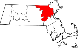 | |
| Towns |
| |
| CDPs | ||
| Other villages |
| |
| Authority control |
|
|---|