Chester, New Hampshire
Chester is a town in Rockingham County, New Hampshire, United States. The population was 4,768 at the 2010 census.[1] It was home to the now defunct Chester College (formerly White Pines College).
Chester, New Hampshire | |
|---|---|
 | |
 Seal | |
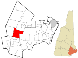 Location in Rockingham County and the state of New Hampshire. | |
| Coordinates: 42°57′24″N 71°15′26″W | |
| Country | United States |
| State | New Hampshire |
| County | Rockingham |
| Incorporated | 1722 |
| Government | |
| • Board of Selectmen | Jeremy Owens, Chair Stephen D'Angelo Joseph M. Hagan Stephen O. Landau Chuck Myette |
| Area | |
| • Total | 26.0 sq mi (67.4 km2) |
| • Land | 25.9 sq mi (67.1 km2) |
| • Water | 0.1 sq mi (0.3 km2) 0.42% |
| Elevation | 467 ft (142 m) |
| Population (2010) | |
| • Total | 4,768 |
| • Density | 180/sq mi (71/km2) |
| Time zone | UTC-5 (Eastern) |
| • Summer (DST) | UTC-4 (Eastern) |
| ZIP code | 03036 |
| Area code(s) | 603 Exchange: 887 |
| FIPS code | 33-12100 |
| GNIS feature ID | 0873564 |
| Website | www |
History
From Statistics and Gazetteer of New-Hampshire, 1875:
"Chester is considered one of the old towns of the state. In 1719, about eighty persons, chiefly from Portsmouth and Hampton, formed an association, for the purpose of securing a tract of land in the "Chesnut Country" (so called) and stationed three men upon this tract, to hold possession until they should procure a lawful title. After considerable difficulty they obtained a grant of land, ten miles [16 km] square. Immediately the settlement was commenced by several persons from Rye and Hampton, among whom were Samuel Ingalls, Jonathan Goodhue, Jacob Sargent, Ebenezer Dearborn, Robert Smith, E. Colby and S. Robie, who contributed largely to the permanent success of the enterprise. On the 8th of May, 1722 the township which had hitherto been called Cheshire, was incorporated under its present name, and comprising an area of over 120 square miles [310 km2]."[2]
Chester once included Candia, set off in 1763. It may have been the first of the settlement grants by Massachusetts selected for expansion of growing populations in the seacoast. The name may be derived from Chester, the county town of the county of Cheshire in England. Earl of Chester is a title held by the Prince of Wales.
In 1822, a portion of Hooksett was taken from Chester. In 1845, the portion of the town known as Long Meadows was incorporated under the name of Auburn.[2]
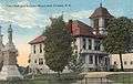 Town Hall in 1913
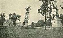
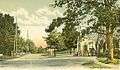 Blacksmith Shop in 1909
 Chester Street c. 1910
Geography
According to the United States Census Bureau, the town has a total area of 26.0 square miles (67 km2), of which 25.9 sq mi (67 km2) is land and 0.1 sq mi (0.26 km2) (0.42%) is water. The Exeter River rises in Chester. The highest point in town is found on an unnamed hill west of Bell Hill and northwest of Harantis Lake; it has two knobs of almost equal elevation of at least 635 feet (194 m), according to the most recent (2011-2012) USGS 7.5-minute topographical map.[3] Chester lies mostly within the Piscataqua River (Coastal) watershed, though the western edge of town is in the Merrimack River watershed.[4]
Adjacent municipalities
- Raymond, New Hampshire (north)
- Fremont, New Hampshire (east)
- Sandown, New Hampshire (southeast)
- Derry, New Hampshire (south)
- Auburn, New Hampshire (west)
- Candia, New Hampshire (northwest)
Demographics
| Historical population | |||
|---|---|---|---|
| Census | Pop. | %± | |
| 1790 | 1,902 | — | |
| 1800 | 2,046 | 7.6% | |
| 1810 | 2,030 | −0.8% | |
| 1820 | 2,262 | 11.4% | |
| 1830 | 2,039 | −9.9% | |
| 1840 | 1,304 | −36.0% | |
| 1850 | 1,301 | −0.2% | |
| 1860 | 1,275 | −2.0% | |
| 1870 | 1,153 | −9.6% | |
| 1880 | 1,136 | −1.5% | |
| 1890 | 958 | −15.7% | |
| 1900 | 861 | −10.1% | |
| 1910 | 818 | −5.0% | |
| 1920 | 652 | −20.3% | |
| 1930 | 653 | 0.2% | |
| 1940 | 702 | 7.5% | |
| 1950 | 807 | 15.0% | |
| 1960 | 1,053 | 30.5% | |
| 1970 | 1,382 | 31.2% | |
| 1980 | 2,006 | 45.2% | |
| 1990 | 2,691 | 34.1% | |
| 2000 | 3,792 | 40.9% | |
| 2010 | 4,768 | 25.7% | |
| Est. 2017 | 5,112 | [5] | 7.2% |
| U.S. Decennial Census[6] | |||
As of the census[7] of 2000, there were 3,792 people, 1,214 households, and 1,011 families residing in the town. The population density was 146.4 people per square mile (56.5/km2). There were 1,247 housing units at an average density of 48.1 per square mile (18.6/km2). The racial makeup of the town was 97.97% White, 0.26% African American, 0.42% Native American, 0.32% Asian, 0.16% from other races, and 0.87% from two or more races. Hispanic or Latino of any race were 0.82% of the population.
There were 1,214 households, out of which 45.0% had children under the age of 18 living with them, 73.3% were married couples living together, 6.6% had a female householder with no husband present, and 16.7% were non-families. 11.8% of all households were made up of individuals, and 4.3% had someone living alone who was 65 years of age or older. The average household size was 3.09 and the average family size was 3.38.
In the town, the population was spread out, with 31.0% under the age of 18, 6.3% from 18 to 24, 32.1% from 25 to 44, 24.6% from 45 to 64, and 6.1% who were 65 years of age or older. The median age was 36 years. For every 100 females, there were 97.8 males. For every 100 females age 18 and over, there were 94.4 males.
The median income for a household in the town was $68,571, and the median income for a family was $75,092. Males had a median income of $44,056 versus $35,382 for females. The per capita income for the town was $23,842. About 3.4% of families and 5.0% of the population were below the poverty line, including 5.9% of those under age 18 and 5.2% of those age 65 or over.
According to the most recent figures Chester has the third highest median property values in the state, and Chester residents have the highest median income.
Education
Elementary and middle school students attend Chester Academy (public). High school students attend Pinkerton Academy in Derry, a privately operated school that contracts with the towns of Derry, Auburn, Chester, Candia, Hooksett, and Hampstead.
Notable people
- Charles H. Bell, 38th governor of New Hampshire and son of John Bell[8]
- John Bell, 12th governor of New Hampshire[9]
- Samuel Bell, 8th governor of New Hampshire and brother of John Bell[10]
- Samuel Newell Bell, US congressman and grandson of Samuel Bell[11]
- "Lord" Timothy Dexter, early American businessman[12]
- Daniel Chester French, sculptor (summer resident)[12]
- George Cochrane Hazelton, US congressman from Wisconsin; brother of Gerry Whiting Hazelton[13]
- Gerry Whiting Hazelton, US congressman from Wisconsin; brother of George Cochrane Hazelton[14]
- Arthur Livermore, US congressman[15]
References
- United States Census Bureau, U.S. Census website, 2010 Census figures. Retrieved March 23, 2011.
- Article in Statistics and Gazetteer of New-Hampshire (1875)
- "Archived copy". Archived from the original on 2016-01-13. Retrieved 2014-03-30.CS1 maint: archived copy as title (link)
- Foster, Debra H.; Batorfalvy, Tatianna N.; Medalie, Laura (1995). Water Use in New Hampshire: An Activities Guide for Teachers. U.S. Department of the Interior and U.S. Geological Survey.
- "Annual Estimates of the Resident Population: April 1, 2010 to July 1, 2017 (PEPANNRES): Minor Civil Divisions – New Hampshire". Archived from the original on February 13, 2020. Retrieved November 15, 2018.
- "Census of Population and Housing". Census.gov. Retrieved June 4, 2016.
- "U.S. Census website". United States Census Bureau. Retrieved 2008-01-31.
- "BELL, Charles Henry, (1823 - 1893)". Biographical Directory of the United States Congress. Retrieved January 22, 2014.
- "Notable People". Chester Historical Society. Retrieved January 22, 2014.
- "BELL, Samuel, (1770 - 1850)". Biographical Directory of the United States Congress. Retrieved January 14, 2014.
- "BELL, Samuel, (1770 - 1850)". Biographical Directory of the United States Congress. Retrieved January 22, 2014.
- "Notable People". Chester Historical Society. Retrieved January 22, 2014.
- "HAZELTON, George Cochrane, (1832 - 1922". Biographical Directory of the United States Congress. Retrieved January 22, 2014.
- "HAZELTON, Gerry Whiting, (1829 - 1920)". Biographical Directory of the United States Congress. Retrieved January 22, 2014.
- "LIVERMORE, Arthur, (1766 - 1853)". Biographical Directory of the United States Congress. Retrieved January 14, 2014.
External links
- Town of Chester official website
- Chester Academy & SAU 82 ~ Chester School District Website
- Pinkerton Academy Website
- Tri-Town Times community newspaper
- Chester Historical Society
- New Hampshire Economic and Labor Market Information Bureau Profile
Places adjacent to Chester, New Hampshire | |
|---|---|
Municipalities and communities of Rockingham County, New Hampshire, United States | ||
|---|---|---|
| City | 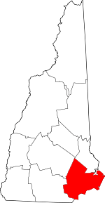 Map of New Hampshire highlighting Rockingham County | |
| Towns |
| |
| CDPs | ||
| Other villages | ||
| Authority control |
|
|---|