Greenland, New Hampshire
Greenland is a town in Rockingham County, New Hampshire, United States. The population was 3,549 at the 2010 census.[1] It is drained by the Winnicut River and bounded on the northwest by Great Bay.
Greenland, New Hampshire | |
|---|---|
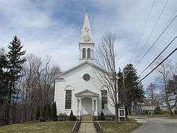 Community Congregational Church | |
 Seal | |
 Location in Rockingham County and the state of New Hampshire. | |
| Coordinates: 43°02′10″N 70°49′58″W | |
| Country | United States |
| State | New Hampshire |
| County | Rockingham |
| Incorporated | 1721 |
| Government | |
| • Board of Selectmen | Chip Hussey, Chair Chester Deorocki Jim Rolston Rick Hussey Steve Smith |
| • Town Administrator | Matt Scruton |
| Area | |
| • Total | 13.3 sq mi (34.4 km2) |
| • Land | 10.5 sq mi (27.2 km2) |
| • Water | 2.8 sq mi (7.3 km2) 21.07% |
| Elevation | 59 ft (18 m) |
| Population (2010) | |
| • Total | 3,549 |
| • Density | 270/sq mi (100/km2) |
| Time zone | UTC-5 (Eastern) |
| • Summer (DST) | UTC-4 (Eastern) |
| ZIP code | 03840 |
| Area code(s) | 603 |
| FIPS code | 33-31700 |
| GNIS feature ID | 0873612 |
| Website | www |
History
One of the earliest settlements in the state, Greenland was a parish of Portsmouth (then called Strawbery Banke) operating in 1638.[2] Captain Francis Champernowne moved from Strawbery Banke in 1640[3] and settled in the area of the present Portsmouth Country Club. Although it was originally to be called Canary, he would call his farm "Greenland". His extensive landholdings included a farm which is now the town of Madbury, named for his ancestral home in Devon, England.
Residents requested and were granted a separate parish in 1706. In c. 1710, Captain Samuel Weeks constructed a substantial brick house, thought to be the oldest brick house in New Hampshire still standing. It survived the 1755 Cape Ann earthquake. Only the 18-inch thick (46 cm) beams that supported the structure were cracked during the quake. The Weeks House is denoted by a New Hampshire historical marker (number 113) along New Hampshire Route 33.[4]
Greenland would incorporate in 1721. Greenland annexed parts of Stratham in 1805 and 1847.
Geography
According to the United States Census Bureau, the town has a total area of 13.3 square miles (34 km2), of which 10.5 sq mi (27 km2) is land and 2.8 sq mi (7.3 km2) is water, comprising 21.07% of the town. The highest point in Greenland is Breakfast Hill, at 151 feet (46 m) above sea level), on the town's border with Rye. Greenland abuts Great Bay to the north and is primarily drained by the Winnicut River. Greenland lies fully within the Piscataqua River (Coastal) watershed.[5]
Adjacent municipalities
- Newington, New Hampshire (north)
- Portsmouth, New Hampshire (east)
- Rye, New Hampshire (southeast)
- North Hampton, New Hampshire (south)
- Stratham, New Hampshire (west)
- Newmarket, New Hampshire (northwest)
Demographics
| Historical population | |||
|---|---|---|---|
| Census | Pop. | %± | |
| 1790 | 634 | — | |
| 1800 | 548 | −13.6% | |
| 1810 | 592 | 8.0% | |
| 1820 | 634 | 7.1% | |
| 1830 | 680 | 7.3% | |
| 1840 | 726 | 6.8% | |
| 1850 | 730 | 0.6% | |
| 1860 | 762 | 4.4% | |
| 1870 | 695 | −8.8% | |
| 1880 | 695 | 0.0% | |
| 1890 | 647 | −6.9% | |
| 1900 | 607 | −6.2% | |
| 1910 | 575 | −5.3% | |
| 1920 | 623 | 8.3% | |
| 1930 | 577 | −7.4% | |
| 1940 | 695 | 20.5% | |
| 1950 | 719 | 3.5% | |
| 1960 | 1,196 | 66.3% | |
| 1970 | 1,784 | 49.2% | |
| 1980 | 2,124 | 19.1% | |
| 1990 | 2,768 | 30.3% | |
| 2000 | 3,208 | 15.9% | |
| 2010 | 3,549 | 10.6% | |
| Est. 2017 | 4,035 | [6] | 13.7% |
| Historical Census Data[7] 2013 Estimate[8] | |||
As of the census[9] of 2000, there were 3,208 people, 1,204 households, and 892 families residing in the town. The population density was 305.9 people per square mile (118.1/km²). There were 1,244 housing units at an average density of 118.6 per square mile (45.8/km²). The racial makeup of the town was 97.79% White, 0.28% African American, 0.03% Native American, 1.22% Asian, 0.03% Pacific Islander, 0.12% from other races, and 0.53% from two or more races. Hispanic or Latino of any race were 0.72% of the population.
There were 1,204 households out of which 36.2% had children under the age of 18 living with them, 62.5% were married couples living together, 8.1% had a female householder with no husband present, and 25.9% were non-families. 19.2% of all households were made up of individuals and 6.4% had someone living alone who was 65 years of age or older. The average household size was 2.65 and the average family size was 3.07.
In the town, the population was spread out with 26.5% under the age of 18, 4.4% from 18 to 24, 32.9% from 25 to 44, 26.2% from 45 to 64, and 10.1% who were 65 years of age or older. The median age was 38 years. For every 100 females, there were 92.1 males. For every 100 females age 18 and over, there were 89.5 males.
The median income for a household in the town was $62,172, and the median income for a family was $67,188. Males had a median income of $44,592 versus $31,815 for females. The per capita income for the town was $31,270. About 3.6% of families and 5.9% of the population were below the poverty line, including 10.1% of those under age 18 and 5.7% of those age 65 or over.
Notable people
- Oney Judge (1773–1848), fugitive slave from the household of George Washington[10]
- John F. Richards (1938–2007), a historian of South Asia specializing in the Mughal Empire.[11]
- Benjamin F. Whidden, first ambassador to Haiti[12]
References
- United States Census Bureau, U.S. Census website, 2010 Census figures. Retrieved March 23, 2011.
- "Archived copy". Archived from the original on 2013-12-09. Retrieved 2013-07-12.CS1 maint: archived copy as title (link)
- http://www.weekslibrary.org/history.html#Captain Archived 2013-12-09 at the Wayback Machine Francis Champernowne
- "List of Markers by Marker Number" (PDF). nh.gov. New Hampshire Division of Historical Resources. November 2, 2018. Retrieved July 5, 2019.
- Foster, Debra H.; Batorfalvy, Tatianna N.; Medalie, Laura (1995). Water Use in New Hampshire: An Activities Guide for Teachers. U.S. Department of the Interior and U.S. Geological Survey.
- "Annual Estimates of the Resident Population: April 1, 2010 to July 1, 2017 (PEPANNRES): Minor Civil Divisions – New Hampshire". Archived from the original on February 13, 2020. Retrieved November 15, 2018.
- "Historical Census Data". NH.gov. Retrieved December 30, 2014.
- "2013 Population Estimates of New Hampshire Cities and Towns" (PDF). NH Office of Energy and Planning. Retrieved December 31, 2014.
- "U.S. Census website". United States Census Bureau. Retrieved 2008-01-31.
- http://www.weekslibrary.org/history.html#Ona Archived 2013-12-09 at the Wayback Machine Maria Judge
- Richards, John F. (March 1993). "The Mughal Empire". Cambridge Core. doi:10.1017/cbo9780511584060. Retrieved 2020-06-19.
- Proceedings - Grafton and Coös County Bar Association, New Hampshire By Grafton and Coos Bar Association, p. 351-358
External links
- Town of Greenland official website
- Weeks Public Library, with town historical information
- New Hampshire Economic and Labor Market Information Bureau Profile
Places adjacent to Greenland, New Hampshire | |
|---|---|
Municipalities and communities of Rockingham County, New Hampshire, United States | ||
|---|---|---|
| City | 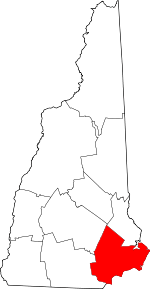 Map of New Hampshire highlighting Rockingham County | |
| Towns |
| |
| CDPs | ||
| Other villages | ||
| Authority control |
|
|---|