Meredith, New Hampshire
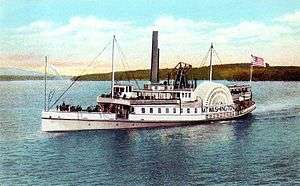
Meredith is a town in Belknap County, New Hampshire, United States. The population was 6,241 at the 2010 census.[1] Meredith is situated in the state's Lakes Region and serves as a major resort town. Meredith Village, the commercial center of the town, lies long the shores of Lake Winnipesaukee, and several other large lakes lie partially or completely within the town borders. It is home to the Stonedam Island Natural Area, the Winnipesaukee Scenic Railroad, and serves as one of the ports-of-call for the paddle steamer MS Mount Washington.
Meredith, New Hampshire | |
|---|---|
Town | |
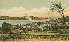
 Bird's-eye view of Meredith village | |
 Seal | |
 Location in Belknap County, New Hampshire | |
| Coordinates: 43°39′28″N 71°30′02″W | |
| Country | United States |
| State | New Hampshire |
| County | Belknap |
| Incorporated | 1768 |
| Villages | Meredith Meredith Center |
| Government | |
| • Board of Selectmen | Nate Torr Jeanie Forrester Ray Moritz Jonathan James Michael Pelczar |
| • Town Manager | Phillip L. Warren, Jr. |
| Area | |
| • Total | 54.2 sq mi (140.4 km2) |
| • Land | 39.9 sq mi (103.4 km2) |
| • Water | 14.3 sq mi (37.0 km2) 26.37% |
| Elevation | 508 ft (155 m) |
| Population (2010) | |
| • Total | 6,241 |
| • Density | 156/sq mi (60.4/km2) |
| Time zone | UTC-5 (Eastern) |
| • Summer (DST) | UTC-4 (Eastern) |
| ZIP code | 03253 |
| Area code(s) | 603 Exchange: 279 |
| FIPS code | 33-47140 |
| GNIS feature ID | 0873662 |
| Website | www |
The primary village in town, where 1,718 people resided at the 2010 census,[1] is defined as the Meredith census-designated place, and is located at the junction of U.S. Route 3 and New Hampshire Route 25 at the head of Meredith Bay on Lake Winnipesaukee.
History
Meredith was first known as Palmer's Town in honor of Samuel Palmer, a teacher of surveying and navigation who laid out much of the land surrounding Lake Winnipesaukee. In 1748, it was one of the first towns to have a charter granted by the Masonian Proprietors. Many grantees were from Salem, Massachusetts, so Palmer's Town was renamed New Salem. It was settled in 1766 by Jacob Eaton and Colonel Ebenezer Smith, then regranted in 1768 by Governor John Wentworth and named after Sir William Meredith, 3rd Baronet, a member of Parliament who opposed taxation on the colonies.
Farmers grew corn, wheat, rye and potatoes, but the area became noted for apple orchards. The outlet of Lake Waukewan provided water power sites, and by 1859 Meredith village had a sawmill, gristmill, shingle mill, blacksmith shop, harness-maker's shop and tannery. Situated at the outlet of Wickwas Lake, Meredith Center had a sawmill, gristmill and blacksmith shop. Connected by the Boston, Concord & Montreal Railroad in March 1849, the town became a summer resort. Passengers also arrived from the Alton Bay depot aboard steamboats, the most famous of which was the original SS Mount Washington, launched in 1872. Meredith remains a popular tourist destination.
Geography

According to the United States Census Bureau, the town has a total area of 54.2 square miles (140.4 km2), of which 39.9 square miles (103.4 km2) is land and 14.3 square miles (37.0 km2) or 26.37% is water.[2] The highest point in Meredith is the summit of Leavitt Mountain, elevation 1,414 feet (431 m) above sea level, in the southwestern part of town.
Meredith village is the commercial hub of the town, lying between the northern tip of Meredith Bay (one of several large arms of Lake Winnipesaukee) and Lake Waukewan. A second village, Meredith Center, is located near the shores of Lake Wickwas closer to the geographic center of the town. Meredith Center has much less commercial development than Meredith Village, being located near several protected state forests and wildlife areas.
The town is crossed by U.S. Route 3, New Hampshire Route 25, New Hampshire Route 104, and New Hampshire Route 106. It is bordered by the towns of Sanbornton to the southwest, New Hampton to the west, Center Harbor to the north, Moultonborough to the northeast across Lake Winnipesaukee, Gilford to the southeast, and Laconia to the south.
Like many other towns of the Lakes Region, Meredith is dominated by several large bodies of water. About half of the town's southeastern boundary with its neighbor Laconia is occupied by Winnisquam Lake, while the northern half of town lies within a peninsula, Meredith Neck, that separates Meredith Bay from the main body of Lake Winnipesaukee, giving Meredith an extensive coastline. Bear Island, the second largest on Winnipesaukee, and Stonedam Island, along with dozens of smaller islands are also part of the town. Several smaller lakes lie between Winnipesaukee and Winnisquam, including Wickwas Lake and Pemigewasset Lake. Lake Waukewan forms the western edge of the Meredith Village CDP and extends into neighboring New Hampton.
Adjacent municipalities
- Center Harbor (north)
- Moultonborough (northeast)
- Gilford (southeast)
- Laconia (south)
- Sanbornton (southwest)
- New Hampton (west)
Demographics
| Historical population | |||
|---|---|---|---|
| Census | Pop. | %± | |
| 1790 | 881 | — | |
| 1800 | 1,609 | 82.6% | |
| 1810 | 1,940 | 20.6% | |
| 1820 | 2,416 | 24.5% | |
| 1830 | 2,683 | 11.1% | |
| 1840 | 3,344 | 24.6% | |
| 1850 | 3,521 | 5.3% | |
| 1860 | 1,944 | −44.8% | |
| 1870 | 1,807 | −7.0% | |
| 1880 | 1,800 | −0.4% | |
| 1890 | 1,642 | −8.8% | |
| 1900 | 1,713 | 4.3% | |
| 1910 | 1,638 | −4.4% | |
| 1920 | 1,680 | 2.6% | |
| 1930 | 1,902 | 13.2% | |
| 1940 | 2,192 | 15.2% | |
| 1950 | 2,222 | 1.4% | |
| 1960 | 2,434 | 9.5% | |
| 1970 | 2,904 | 19.3% | |
| 1980 | 4,646 | 60.0% | |
| 1990 | 4,837 | 4.1% | |
| 2000 | 5,943 | 22.9% | |
| 2010 | 6,241 | 5.0% | |
| Est. 2017 | 6,384 | [3] | 2.3% |
| U.S. Decennial Census[4] | |||

As of the census of 2010, there were 6,241 people, 2,708 households, and 1,777 families residing in the town. There were 4,728 housing units, of which 2,020, or 42.7%, were vacant. 1,710 of the vacant units were for seasonal or recreational use. The racial makeup of the town was 97.3% white, 0.3% African American, 0.2% Native American, 0.9% Asian, 0.0% Native Hawaiian or Pacific Islander, 0.3% some other race, and 1.0% from two or more races. 1.1% of the population were Hispanic or Latino of any race.[5]
Of the 2,941 households, 25.5% had children under the age of 18 living with them, 51.4% were headed by married couples living together, 9.9% had a female householder with no husband present, and 34.4% were non-families. 27.5% of all households were made up of individuals, and 11.6% were someone living alone who was 65 years of age or older. The average household size was 2.27, and the average family size was 2.71.[5]
In the town, 18.6% of the population were under the age of 18, 5.8% were from 18 to 24, 19.7% from 25 to 44, 34.9% from 45 to 64, and 20.8% were 65 years of age or older. The median age was 48.7 years. For every 100 females, there were 93.6 males. For every 100 females age 18 and over, there were 91.3 males.[5]
For the period 2011-2015, the estimated median annual income for a household was $63,028, and the median income for a family was $80,076. Male full-time workers had a median income of $62,944 versus $42,734 for females. The per capita income for the town was $36,510. 12.4% of the population and 8.7% of families were below the poverty line. 22.5% of the population under the age of 18 and 7.1% of those 65 or older were living in poverty.[6]
Government
In the New Hampshire Senate, Meredith is in the 2nd District, represented by Republican Bob Giuda. On the New Hampshire Executive Council, Meredith is in the 1st District, represented by Democrat Mike Cryans. In the United States House of Representatives, Meredith is in New Hampshire's 1st congressional district, represented by Democrat Chris Pappas.
Education
Meredith's Inter-Lakes Middle High School is home to the Inter-Lakes Community Auditorium, which plays host to the Summer Theatre in Meredith Village (formerly the Lakes Region Summer Theater) every summer. Inter-Lakes Elementary School serves children from Meredith and neighboring Center Harbor. The high school also includes students from the town of Sandwich.
Notable people
- Bradford Anderson, actor[7]
- Samuel Newell Bell, US congressman[8]
- Charles A. Busiel, manufacturer; US congressman and the 45th governor of New Hampshire[9]
- Joseph Libbey Folsom, army officer and real estate investor
- George G. Fogg, US senator and diplomat
- Samuel Green, criminal
- Dudley Leavitt, publisher
- Bob Montana, illustrator of Archie Comics
- George Orton, Canadian middle-distance runner; Olympic gold medalist
- Eben Ezra Roberts, architect
- Daniel E. Somes, US congressman
Sites of interest

- Museums
- Regional theatres and summer stock
- The Summer Theatre in Meredith Village
- In 2008 the Winnipesaukee Playhouse purchased the former Annalee Dolls factory in Meredith.[10] In 2013, the theatre completed construction of its new facility and moved from its former site in Weirs Beach to the site of the former Annalee gift shop.
- Orchestras
- Islands
- Bear Island
- Pine Island
References
- United States Census Bureau, American FactFinder, 2010 Census figures. Retrieved March 23, 2011.
- "Geographic Identifiers: 2010 Demographic Profile Data (G001) - Meredith town, New Hampshire". United States Census Bureau. Retrieved November 7, 2011.
- "Annual Estimates of the Resident Population: April 1, 2010 to July 1, 2017 (PEPANNRES): Minor Civil Divisions – New Hampshire". Archived from the original on February 13, 2020. Retrieved November 14, 2018.
- "Census of Population and Housing". Census.gov. Retrieved June 4, 2016.
- "Profile of General Population and Housing Characteristics: 2010 Census Summary File 1 (DP-1): Meredith town, Belknap County, New Hampshire". U.S. Census Bureau, American Factfinder. Archived from the original on February 13, 2020. Retrieved October 25, 2017.
- "Selected Economic Characteristics: 2011-2015 American Community Survey 5-Year Estimates (DP03): Meredith town, Belknap County, New Hampshire". U.S. Census Bureau, American Factfinder. Archived from the original on February 13, 2020. Retrieved October 25, 2017.
- "Bradford Anderson". NewHampshire.com. Retrieved January 22, 2014.
- "BELL, Samuel, (1770 - 1850)". Biographical Directory of the United States Congress. Retrieved January 22, 2014.
- Willey, George Franklyn (1903). State Builders: An Illustrated Historical and Biographical Record of the State of New Hampshire at the Beginning of the Twentieth Century. The New Hampshire Publishing Corporation. p. 392.
- "Annalee property sold for playhouse". New Hampshire Business Review. 2008-02-01. Retrieved 2008-08-09.
Further reading
External links
| Wikimedia Commons has media related to Meredith, New Hampshire. |
- Town of Meredith official website
- Meredith Public Library
- The Greater Meredith Program, a community development organization
- Meredith Area Chamber of Commerce
- New Hampshire Economic and Labor Market Information Bureau Profile
Places adjacent to Meredith, New Hampshire | |
|---|---|
Municipalities and communities of Belknap County, New Hampshire, United States | ||
|---|---|---|
| City |  Map of New Hampshire highlighting Belknap County | |
| Towns | ||
| CDPs | ||
| Other villages | ||
| Footnotes | ‡This populated place also has portions in an adjacent county or counties | |