Westwood, Massachusetts
Westwood is a town in Norfolk County, Massachusetts, United States. The population was 16,057 in 2017. In July 2005, CNN/Money and Money magazine ranked Westwood 13th on its list of the 100 Best Places to Live in the United States. Boston magazine included Gay Street in Westwood on its list of the Best Streets in the Boston area. It is the 9th wealthiest town in the state of Massachusetts.
Westwood, Massachusetts | |
|---|---|
 From left to right: Westwood First Parish Church, inscription on town clock, Fisher School House, Hale Reservation, Town Hall, and the Old Burial Ground | |
 Seal | |
| Motto(s): "Committed to service" | |
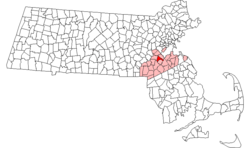 Location in Norfolk County in Massachusetts | |
| Coordinates: 42°12′50″N 71°13′30″W | |
| Country | |
| State | |
| County | |
| Settled | 1640 |
| Incorporated | 1897 |
| Government | |
| • Type | Open town meeting |
| Area | |
| • Total | 28.8 km2 (11.1 sq mi) |
| • Land | 28.4 km2 (11.0 sq mi) |
| • Water | 0.4 km2 (0.2 sq mi) |
| Elevation | 67 m (220 ft) |
| Population (2017) | |
| • Total | 16,056 |
| • Density | 514.7/km2 (1,328.9/sq mi) |
| Time zone | UTC-5 (Eastern) |
| • Summer (DST) | UTC-4 (Eastern) |
| ZIP code | 02090 |
| Area code(s) | 339 / 781 |
| FIPS code | 25-78690 |
| GNIS feature ID | 0618333 |
| Website | www.townhall.westwood.ma.us |
History
Westwood was first settled in 1641 and was part of the town of Dedham, originally called 'West Dedham', until it was officially incorporated in 1897. It was the last town to split from the original town of Dedham. From early in the settlement of Dedham, the people of the Clapboard Trees Precinct were "a wealthy, sophisticated lot, familiar with the bigwigs of provincial politics and prone to the religious liberalism that was à la mode in Boston."[1] Residents did not care for the politically more powerful Calvinist views of those who lived in the village of Dedham and asked to separate.[2]
It was originally to have been named the "Town of Nahatan:"
a bill to incorporate the Town of Nahatan was reported in the Senate on March 8, 1897, by Senator Charles F. Woodward, Chairman of the Committee on Towns. No opposition to the passage of the bill appeared until it reached the House, when the representative from Nahant objected to the name "Nahatan," owing to its alleged similarity to the name Nahant. It was desirable for the old, as well as the new town, to have the question of incorporation settled, if possible, before April 5, when appropriations for the coming year were going to be made. Therefore, in order to remove every trace of friction, however trivial, and thus expedite matters, the name was changed to Westwood.[3]
In July 2005, CNN/Money and Money magazine ranked Westwood 13th on its list of the 100 Best Places to Live in the United States. Boston magazine listed Gay Street in Westwood on its list of the Best Streets in the Boston area.
Geography
According to the United States Census Bureau, the town has a total area of 11.1 square miles (29 km2), of which, 11.0 square miles (28 km2) of it is land and 0.2 square miles (0.52 km2) of it (1.35%) is water.
Demographics
| Historical population | ||
|---|---|---|
| Year | Pop. | ±% |
| 1900 | 1,112 | — |
| 1910 | 1,266 | +13.8% |
| 1920 | 1,358 | +7.3% |
| 1930 | 2,097 | +54.4% |
| 1940 | 3,376 | +61.0% |
| 1950 | 5,837 | +72.9% |
| 1960 | 10,354 | +77.4% |
| 1970 | 12,750 | +23.1% |
| 1980 | 13,212 | +3.6% |
| 1990 | 12,557 | −5.0% |
| 2000 | 14,117 | +12.4% |
| 2010 | 14,618 | +3.5% |
| 2017 | 16,056 | +9.8% |
| * = population estimate. Source: United States Census records and Population Estimates Program data.[4][5][6][7][8][9] | ||
As of the census[10] of 2000, there were 14,117 people, 5,122 households and 3,867 families residing in the town. The population density was 1,286.7 people per square mile (496.9/km²). There were 5,251 housing units at an average density of 478.6/sq mi (184.8/km²). The racial makeup of the town was 95.98% White, 0.50% African American, 0.04% Native American, 2.48% Asian, 0.21% from other races, and 0.79% from two or more races. Hispanic or Latino of any race were 0.94% of the population.
There were 5,122 households out of which 36.5% had children under the age of 18 living with them, 67.1% were married couples living together, 6.5% had a female householder with no husband present, and 24.5% were non-families. 22.5% of all households were made up of individuals and 16.4% had someone living alone who was 65 years of age or older. The average household size was 2.73 and the average family size was 3.24.
In the town, the population was spread out with 27.8% under the age of 18, 3.4% from 18 to 24, 25.4% from 25 to 44, 24.2% from 45 to 64, and 19.1% who were 65 years of age or older. The median age was 41 years. For every 100 females, there were 90.7 males. For every 100 females age 18 and over, there were 85.5 males.
The median income for a household in the town was $128,984, and the median income for a family was $157,656. Males had a median income of $71,801 versus $46,194 for females. The per capita income for the town was $71,553. About 1.3% of families and 2.5% of the population were below the poverty line, including 1.5% of those under age 18 and 5.0% of those age 65 or over.
Government
The town of Westwood operates under a home rule charter. This means that the town is given a degree of autonomy in regards to internal affairs. The charter defines the powers of elected boards, including the board of selectmen, which serves as the executive branch of government and hires a Town Administrator responsible for day-to-day operations of town departments. The legislative branch operates through open town meeting, which meets at least once and often twice a year where all residents are entitle to speak and vote on approval of warrant articles which authorize the town budget and may create or modify town bylaws. Selectmen and other town officials are elected through an annual town election at the end of April. The board of selectmen appoints residents to various volunteer boards and committees. The Town Administrator appoints town staff who manage public safety, recreation, and other services. The board of selectmen has three members who serve overlapping three-year terms. Michael F. Walsh, John M. Hickey, and Nancy Hyde are currently Westwood's selectmen. On April 24, 2018, Hyde was opposed by Ellen Larkin Rollings and was elected to her 4th consecutive term on the board. Walsh's term will be up in 2019, and Hickey's in 2020.[11]
Education
Public schools
Westwood has five public elementary schools:
- Deerfield
- Downey
- Paul R. Hanlon (originally Pine Hill)
- Martha Jones
- William E. Sheehan (originally Pond Plain)
Westwood has one public middle school, Thurston Middle School,[12] named after Edmund W. Thurston. Westwood High School, the only high school in Westwood, serves the Westwood area.
Westwood High School was recently rebuilt at a cost of $45 million, and the old school, built in 1957, was demolished. The gymnasium and swimming facility from the old school were refurbished and are now part of the new high school campus. The school facilities also include a new multi-use artificial turf field (named after former Westwood High School principal and teacher Charles Flahive) with a synthetic track, both of which are open to the public.
Private schools
Westwood is home to Xaverian Brothers High School, an all-boys Catholic prep school and the Westwood Montessori School.
Points of interest
- Hale Reservation – A Home to North Beach, Membership Beach, several walking trails, and other outdoor areas.
- Westwood Library – On April 7, 2010, Library Trustees hosted a groundbreaking ceremony for the town's new library. The new building was opened in Summer 2013.
- Colburn School – A school built in 1877 that is listed in the National Register of Historic Places.
- University Station – A recently built outdoor mall with restaurants, shops, and condos. University Station abuts Route 128 station, a rail station serving Amtrak and the MBTA commuter rail.
Houses of worship
- First Baptist Church of Westwood, 808 High Street (Association: American Baptist)
- First Parish of Westwood United Church, 340 Clapboardtree Street (Association: United Church of Christ, Unitarian Universalist Association).
- Temple Beth David, 7 Clapboardtree Street (Association: Union for Reform Judaism)
- St. Denis Parish, 157 Washington Street (Association: Catholic Archdiocese of Boston)
- St. John's Episcopal Church, 95 Deerfield Avenue (Association: Episcopal Diocese of Eastern Massachusetts) stjohnswestwood.org
- St. Margaret Mary Parish, 845 High Street (Association: Catholic Archdiocese of Boston)
- St. Timothy Catholic Church, 650 Nichols Street (Association: Catholic Archdiocese of Boston)
Westwood has an active Interfaith Council.
Transportation
- Commuter rail service from Boston's South Station is provided by the MBTA with the Route 128 station on its Providence/Stoughton Line, and the Islington station on its Franklin Line
- Amtrak trains to Providence, New Haven, New York City and Washington, D.C. also stop at the Route 128 station.
Trivia
- The remains of a cave sit along Route 109, that King Philip and his men hid inside during King Philip's War. The massive rock that once contained the cave was known as the "Oven's Mouth." It was blown up along with most of the cave in the 1950s to straighten out Route 109.
- Maj. Robert Steele, the Continental Army drummer boy during the Battle of Bunker Hill, is buried in the old Westwood Cemetery off Route 109.
- Westwood is home of the oldest animal pound in the United States.
- Westwood was a dry town until 2005. Restaurants can now apply for liquor licenses.
- Westwood is home to the Hale Reservation, an area of open space donated by Robert Sever Hale. Hale Reservation spans over 1,200 acres (486 ha) in Westwood and Dover, MA.
Notable people
- Dicky Barrett – lead singer of the ska-core band the Mighty Mighty Bosstones
- Shari Redstone - American media executive; chairwoman of ViacomCBS and president of National Amusements
- Leo Beranek – American acoustic engineer and co-founder of Internet pioneer, Bolt Beranek and Newman
- Mike Cafarella - Computer scientist and co-founder of the Apache Hadoop big data project
- Bishop Christopher Coyne – Served as parish priest of St. Margaret Mary Church
- Jon Finn – guitarist, rock musician
- Fern Flaman – former Boston Bruin and Toronto Maple Leaf. Stanley Cup winner and Hockey Hall of Famer
- Kenny Florian – Mixed Martial Arts (MMA) fighter, FOX/UFC analyst
- John Harrington – former CEO of the Boston Red Sox
- Matt Hasselbeck – NFL quarterback
- Mike Hazen – Executive vice president and general manager of the Arizona Diamondbacks
- Maurice Hurst Jr. – American professional football defensive tackle for the Oakland Raiders
- Jackie MacMullan – Newspaper sportswriter and NBA columnist for ESPN.com
- Jerry McDermott – Sheriff of Norfolk County, Massachusetts
- Peter S. Pezzati – portrait painter
- Barry Reed – American trial lawyer and bestselling author
- Robert B. Rheault – American military officer and commander of all US Army Special Forces in Vietnam in 1969
- Milt Schmidt- former Boston Bruin and Hockey Hall of Famer
- Robert Steele (drum major) – drummer boy for the Continental Army during the Battle of Bunker Hill of the Revolutionary War; buried in the Old Westwood Cemetery.
- Mike Woicik – Strength and conditioning coach for the Dallas Cowboys, and the only person with six Super Bowl rings besides Tom Brady and Bill Belichick.
References
- Lockridge 1985, p. 101.
- Lockridge, Kenneth (1985). A New England Town. New York: W.W. Norton & Company. p. 101. ISBN 978-0-393-95459-3.CS1 maint: ref=harv (link)
- Dedham Historical Register, Vol. VIII. April, 1897. No. 2, "The New Town of Westwood"
- "TOTAL POPULATION (P1), 2010 Census Summary File 1, All County Subdivisions within Massachusetts". United States Census Bureau. Archived from the original on February 12, 2020. Retrieved September 13, 2011.
- "Massachusetts by Place and County Subdivision - GCT-T1. Population Estimates". United States Census Bureau. Archived from the original on February 12, 2020. Retrieved July 12, 2011.
- "1990 Census of Population, General Population Characteristics: Massachusetts" (PDF). US Census Bureau. December 1990. Table 76: General Characteristics of Persons, Households, and Families: 1990. 1990 CP-1-23. Retrieved July 12, 2011.
- "1980 Census of the Population, Number of Inhabitants: Massachusetts" (PDF). US Census Bureau. December 1981. Table 4. Populations of County Subdivisions: 1960 to 1980. PC80-1-A23. Retrieved July 12, 2011.
- "1950 Census of Population" (PDF). 1: Number of Inhabitants. Bureau of the Census. 1952. Section 6, Pages 21-10 and 21-11, Massachusetts Table 6. Population of Counties by Minor Civil Divisions: 1930 to 1950. Retrieved July 12, 2011. Cite journal requires
|journal=(help) - "1920 Census of Population" (PDF). Bureau of the Census. Number of Inhabitants, by Counties and Minor Civil Divisions. Pages 21-5 through 21-7. Massachusetts Table 2. Population of Counties by Minor Civil Divisions: 1920, 1910, and 1920. Retrieved July 12, 2011.
- "U.S. Census website". United States Census Bureau. Retrieved 2008-01-31.
- Westwood, Town Of. "Town Of Westwood, MA Election Results". Westwood MA. Westwood MA. Retrieved May 1, 2018.
- "Thurston Middle School". Westwood Public Schools. Retrieved 14 December 2016.
External links
| Wikimedia Commons has media related to Westwood, Massachusetts. |
- Town of Westwood
- Westwood Press
- Westwood Public Schools
- The Daily News Transcript A newspaper that covers Westwood.
Municipalities and communities of Norfolk County, Massachusetts, United States | ||
|---|---|---|
| Cities | 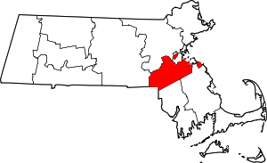 | |
| Towns | ||
| CDPs |
| |
| Other villages | ||
| Authority control |
|
|---|