East Providence, Rhode Island
East Providence is a city in Providence County, Rhode Island, United States. The population was 47,037 at the 2010 census, making it the fifth-largest city in the state.
East Providence, Rhode Island | |
|---|---|
| City of East Providence | |
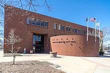
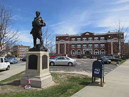 World War I Memorial and Taunton Plaza | |
 Flag | |
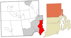 Location in Providence County and the state of Rhode Island. | |
 East Providence Location in Rhode Island  East Providence Location in the United States | |
| Coordinates: 41°48′49″N 71°22′12″W | |
| Country | |
| State | |
| County | Providence County |
| Incorporated (town) | 1862 |
| Incorporated (city) | 1958 |
| Government | |
| • Type | Mayor-council |
| • Mayor | Roberto DaSilva |
| • City Council | Robert Britto: Ward 1 (Council President) Robert Rodericks: At-Large (Council Vice-President): Ward 1 Anna M. Sousa: Ward 2 Nathan Cahoon: Ward 3 Ricardo Mourato: Ward 4 |
| Area | |
| • Total | 43.02 km2 (16.61 sq mi) |
| • Land | 34.7 km2 (13.4 sq mi) |
| • Water | 8.3 km2 (3.2 sq mi) |
| Elevation | 19 m (62 ft) |
| Population (2010) | |
| • Total | 47,037 |
| • Density | 1,355.5/km2 (3,510.2/sq mi) |
| Time zone | UTC−5 (Eastern) |
| • Summer (DST) | UTC−4 (Eastern) |
| ZIP code | 02914, 02915, 02916 |
| Area code(s) | 401 |
| FIPS code | 44-22960[1] |
| GNIS feature ID | 1219590[2] |
| Website | eastprovidenceri.net |
Geography
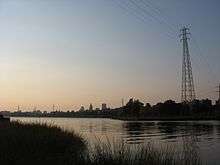
East Providence is located between the Providence and Seekonk Rivers on the west and the Seekonk area of Massachusetts on the east. According to the United States Census Bureau, the city has a total area of 16.6 square miles (43 km2), of which, 13.4 square miles (35 km2) of it is land and 3.2 square miles (8.3 km2) of it (19.33%) is water.
The following villages are located in East Providence:[3]
History
In 1641, the Plymouth Colony purchased from the Indians a large tract of land which today includes the northern half of East Providence (from Watchemoket to Rumford), Rehoboth, Massachusetts, Seekonk, Massachusetts, and part of Pawtucket. Four years later, John Brown of Plymouth bought a considerably smaller piece of land from the Indians, which today comprises the southern part of East Providence (Riverside), Barrington, and a small part of Swansea. Finally, in 1661, Plymouth completed the "North Purchase" from which Attleboro, North Attleboro, and Cumberland were later formed. Over the whole the authorities gave the name 'Rehoboth'. The center of this large settlement, which is sometimes referred to as 'Old Rehoboth', is within the borders of modern East Providence. In 1812, the western half of Old Rehoboth was set off as a separate township called Seekonk, Massachusetts. Old Rehoboth's town center now became the heart of Old Seekonk. Finally, in 1862, the western part of Old Seekonk was ceded to Rhode Island and incorporated as East Providence.
Portuguese immigration
Beginning around 1900 and continuing until the onset of the Depression in 1930, large numbers of Portuguese from Providence, Fall River, New Bedford, and Portugal settled in East Providence. By 1905, there were over 400 Portuguese in the town, the third-highest in the state. The Portuguese, like other ethnic groups, were drawn to East Providence primarily by the lure of jobs. Many employment opportunities were available in the Watchemoket area, where numerous immigrants settled.
Watchemoket Square


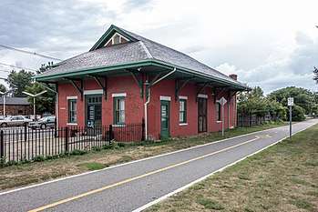
In decades preceding the Civil War, Watchemoket Point was little more than a farming and fishing area with perhaps a few hundred residents. Watchemoket was situated directly across from the thriving city of Providence and thus benefited from the expansion of that community. More importantly, two bridges across the Seekonk River gave easy access to Watchmemoket. By the 1860s, tolls were no longer being charged to cross the Washington and Central Bridges, giving further stimulus to the growth of Watchemoket and the transformation of the village from a sleepy fishing area to the vital core of East Providence in 1862. Perhaps the first businesses to come to Watchemoket were inns built to service the large numbers of people coming through. The residents of Watchemoket also had their own library by the early 1870s. At first the organizers named it Ladies Library Association, but in 1885 they changed the named to Watchemoket Free Public Library. Already the commercial and population center of East Providence, by the mid-1880s, Watchemoket next became the political center as well. The town hall was moved from Rumford to the heart of the community, so it was more accessible. They purchased a lot on Taunton Avenue for $11,500 and erected a two-story brick building which opened in 1889. That same year the East Providence Police Department opened its headquarters in the town hall.
By 1922, Watchemoket Square was the heart of downtown East Providence, supporting over 100 businesses including two department stores, two restaurants, five barber shops, bakeries, and blacksmith shops.[4] Ingraham Hall was village's centerpiece, featuring a concert hall on the second floor and shopping on the first.[4] Buffalo Bill's Wild West Show performed at Ingraham Hall when it came to Rhode Island.[4] An Industrial National Bank branch opened in 1923 with much publicity.[4] Piers lined Narragansett Bay; in 1880, 473 ships docked at Watchemoket unloading 256,000 tons of coal.[4]
However, the neighborhood began a decline when the Washington Bridge drew traffic south of the area in 1927.[4] Then the Hurricane of 1938 demolished the local oyster population.[4] In 1955 Interstate 195 was built through the heart of Watchemoket, resulting in the northern half of the square to be demolished.[4] Buildings which remain include the bank (now a comedy club), St. Mary's Episcopal Church, and Oddfellows' Hall.
Rumford
For some time after the incorporation of the town in 1862, the area around the old "Ring of the Green" was referred to as East Providence Center. The official town hall was located here until 1889, as were several churches. Moreover, the village was the population center of East Providence, containing many farms and mills along the Ten Mile River. Many people migrated from East Providence Center to the new center at Watchemoket.
Riverside
From the time of the Wannamoisett purchase in 1645 to the Civil War, the shore land from Watchemoket to Bullocks Point had remained a sparsely settled fishing and farming area. When East Providence was incorporated, no more than a few hundred of its residents made the coastal village their home. The white settlers had first learned of the plentiful supply of shellfish in the area from the Wampanoag Indians. More than two centuries later, the waters of Narragansett Bay, which washed the shores of Wannamoisett, still contained an abundant supply of edible sea treasures. Clams, quahogs, and oysters were harvested by Wannamoisett residents and sold in Providence. Arnold Medberry, for instance, brought his plow to the shoreline and began picking up clams by the handful. He loaded the shellfish on a cart and easily sold his entire day's catch in Providence. At that time, Medberry and his neighbors were referred to as "clamdiggers", a derogatory term comparable to the pejorative hayseed.
Already, by the early nineteenth century, individuals had begun to build summer homes, causing the population to double to about 500–600. During that time period, Cedar Grove, Lewis Station, Chimney Corners, Peck's Corner, Pleasant Bluffs, Sabin's Point, Sherman's Station, and Pomham were developed. New resort facilities were built, such as the Pomham House. Numbers of roads were lined with trees and houses, Christian churches were formed, a library was built, and the Narragansett Engine Company was formed in 1878. By that time, the residents were no longer dismissed as "clamdiggers", but regarded as townspeople.
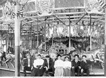
While many transactions were taking place, Charles I. D. Looff came to Riverside. He was a wood carver for a furniture business in New York, and spent spare time in his basement carving wooden horses as a hobby. After long years of hard work, he produced the first steam-powered carousel and sold it to Crescent Park. He operated the carousel and designed a summer recreation area. By the early 1900s, New Englanders recognized Crescent Park as the leading amusement park in the region. Looff accomplished fantastic achievements and, after his death, his family continued to operate Crescent Park. The park closed in the 1970s and the land was used for condominiums. The Crescent Park Looff Carousel still remains.
Waterfront redevelopment
Between 2003 and 2020, the East Providence Waterfront Commission and Planning Department has worked to redevelop old industrial sites and brownfields along most of East Providence's 14-mile coastline on the Seekonk River as mixed use residential, commercial, and light industrial zones.[5]
Governance


The City of East Providence is governed by an elected mayor and a five-member city council, with the mayor and counselors elected every four years. City council members are elected one each from four wards and one elected at-large.
Executive branch
The mayor is both the ceremonial leader of the city and the chief executive officer. The mayor runs the daily operations of the city, enforces the charter and ordinances of the city and appoints all department heads except the city clerk. The current mayor of East Providence is Roberto DaSilva, who took office on January 9, 2019.
Up until January 9, 2019, the day-to-day operations were managed by a professional city manager appointed by the city council, and the mayor was the president of the city council, acting ceremonially.
Legislative branch
The city council sets all city ordinances, sets the budget of the city (with recommendation from the mayor) and provides legislative oversight for city operations.
The city council elects a council president and council vice-president to preside over meetings. The city council also appoints the city clerk.
Up until 2019, The city council served two-year terms, and the city council oversaw the entire city government under a council-manager system.
As of 2019, the members of the East Providence City Council are:
- Robert Rodericks—At-Large (council vice-president)
- Robert Britto—Ward 1 (council president)
- Anna Sousa—Ward 2
- Nathan Cahoon—Ward 3
- Ricardo Mourato—Ward 4
Judicial branch
The City of East Providence has a municipal court, which hears cases regarding violations of municipal ordinances, housing code violations and minor traffic violations. The city also has a probate court, which handles estates, name changes, guardianships and related matters. Judges for both courts are appointed by the mayor with confirmation by the city council for a term of two years.
Education governance
The city also has an elected school committee, elected for two year terms by the same ward system as the city council. The school committee has broad authority to manage the school system, including setting all school system policies, setting the school system budget (within the general appropriation by the city, state and federal government) as well as selecting and overseeing the Superintendent of Schools.
Other boards and commissions
The city has an appointed library board of trustees which governs the city's library system and various other appointed governing and advisory boards and commissions.
Demographics
| Historical population | |||
|---|---|---|---|
| Census | Pop. | %± | |
| 1870 | 2,668 | — | |
| 1880 | 5,056 | 89.5% | |
| 1890 | 8,422 | 66.6% | |
| 1900 | 12,138 | 44.1% | |
| 1910 | 15,808 | 30.2% | |
| 1920 | 21,793 | 37.9% | |
| 1930 | 29,995 | 37.6% | |
| 1940 | 32,165 | 7.2% | |
| 1950 | 35,871 | 11.5% | |
| 1960 | 41,955 | 17.0% | |
| 1970 | 48,207 | 14.9% | |
| 1980 | 50,980 | 5.8% | |
| 1990 | 50,380 | −1.2% | |
| 2000 | 48,688 | −3.4% | |
| 2010 | 47,037 | −3.4% | |
| Est. 2019 | 47,618 | [6] | 1.2% |
| U.S. Decennial Census[7] | |||
As of the census[1] of 2000, there were 48,688 people, 20,530 households, and 12,851 families residing in the city. The population density was 3,632.1 people per square mile (1,401.8/km2). There were 21,309 housing units at an average density of 1,589.6 per square mile (613.5/km2). The racial makeup of the city was 86.49% White, 5.02% African American, 0.46% Native American, 1.15% Asian, 0.05% Pacific Islander, 2.80% from other races, and 4.03% from two or more races. Hispanic or Latino of any race were 1.89% of the population.
There were 20,530 households, out of which 27.1% had children under the age of 18 living with them, 46.3% were married couples living together, 12.7% had a female householder with no husband present, and 37.4% were non-families. 32.4% of all households were made up of individuals, and 14.6% had someone living alone who was 65 years of age or older. The average household size was 2.33 and the average family size was 2.99.
In the city, the population was spread out, with 21.7% under the age of 18, 7.4% from 18 to 24, 29.4% from 25 to 44, 22.6% from 45 to 64, and 18.9% who were 65 years of age or older. The median age was 40 years. For every 100 females, there were 86.8 males. For every 100 females age 18 and over, there were 82.6 males.
The median income for a household in the city was $39,108, and the median income for a family was $48,463. Males had a median income of $34,342 versus $26,423 for females. The per capita income for the city was $19,527. About 6.3% of families and 8.6% of the population were below the poverty line, including 10.7% of those under age 18 and 11.0% of those aged 65 or over.
The population has large immigrant communities from Portugal, the Azores, Madeira and Cape Verde.
Education

East Providence has 13 public and 5 non-public schools:
Public schools
Elementary
- Agnes B. "Hennessey"
- Alice M. "Waddington" - built 1954
- Emma G. "Whiteknact"
- James R.D. "Oldham"
- Kent Heights
- Myron J. "Francis" - built 1989
- Orlo Avenue School
- Silver Spring
Middle schools
- Edward R. Martin Middle School - built 1977
- Riverside Middle School
High school
- Grove Ave. Educational Development Center
- East Providence High School - built 1952
- East Providence Career & Technical Center
Non-public elementary and junior-high schools
- St. Mary "Bayview" Academy
- Sacred Heart School
- St. Margaret School
- The Gordon School
- Providence Country Day (P.C.D.).
Non-public high schools
- St. Mary "Bayview" Academy
- Providence Country Day (P.C.D.).
National Register of Historic Places listings in East Providence
- Bicknell-Armington Lightning Splitter House
- Boston and Providence Railroad Bridge
- Bridgham Farm
- Carpenter, Lakeside, and Springvale Cemeteries
- Crescent Park Looff Carousel, (National Historic Landmark)
- Elm Tree Plat Historic District
- Nathaniel Daggett House
- James Dennis House
- District 6 Schoolhouse
- Little Neck Cemetery
- Newman Cemetery
- Newman Congregational Church
- Oddfellows' Hall
- Pomham Rocks Light Station
- Rose Land Park Plat Historic District
- Richmond Paper Company Mill Complex
- Rumford Chemical Works and Mill House Historic District
- Rumford Historic District
- Squantum Association
- St. Mary's Episcopal Church
- Phillip Walker House
- Whitcomb Farm
- World War I Memorial
Notable people
- Arunah Shepherdson Abell (1806–1888), philanthropist and newspaper publisher (Philadelphia Public Ledger and Baltimore Sun); born in East Providence[8]
- Pedro Braz, soccer defender for the Gigantes de Carolina FC and Western Mass Pioneers; attended East Providence High School
- Rebecca DiPietro, model and WWE Diva; lives in East Providence
- John Michael Greer, author and former Archdruid; lives in East Providence
- Elisabeth Hasselbeck, TV personality on Fox & Friends and The View; attended and graduated from St. Mary Academy – Bay View in 1995
- Jimmy Hatlo, cartoonist, was born in East Providence
- Claudia Jordan, model and reality TV personality (Deal or No Deal, Celebrity Apprentice); Miss Rhode Island USA (1997); grew up in East Providence[9]
- Jennifer Lee, co-writer of screenplay for Wreck-It Ralph; writer of screenplay for and co-director of Frozen; born in East Providence
- Davey Lopes, second baseman and coach for several Major League Baseball teams; born in East Providence
- Jamie Silva, football safety for the Indianapolis Colts; born in East Providence
- Meredith Vieira, presenter of Millionaire, co-host of Today and The View; born in East Providence
- Ron Wilson, hockey defenseman and coach for the US Olympic hockey team and several National Hockey League teams; attended East Providence High School
See also
References
- "U.S. Census website". United States Census Bureau. Retrieved 2008-01-31.
- "US Board on Geographic Names". United States Geological Survey. 2007-10-25. Retrieved 2008-01-31.
- RIGIS Villages data layer Archived 2006-05-09 at the Wayback Machine
- O'Connor, Kevin P. (27 November 2008). "A place that may regain its glory". Fall River, Massachusetts: The Herald News. Gatehosue Media. Retrieved 29 June 2019.
- "Officials remain bullish about future East Providence waterfront district redevelopment". Rhody Beat. 9 June 2020. Retrieved 9 June 2020.
- "Population and Housing Unit Estimates". Retrieved May 21, 2020.
- "Census of Population and Housing". Census.gov. Retrieved June 4, 2015.
- Who Was Who in America, Historical Volume, 1607-1896. Chicago: Marquis Who's Who. 1963.
- Anonymous. "Claudia Jordan". Miss USA. Miss Universe L.P., LLLP. Retrieved 27 June 2013.
Further reading
- Our Heritage: A History of East Providence, Joseph Conforti
External links
| Wikimedia Commons has media related to East Providence, Rhode Island. |
| Wikisource has the text of the 1911 Encyclopædia Britannica article East Providence. |
- City of East Providence
- East Providence School Department
- East Providence Public Library
- East Providence Historical Society
- East Providence Arts Council
- Births Index from the Rhode Island State Archives
- Guide to the East Providence Public Library Genealogical and Reference Materials from the Rhode Island State Archives
Municipalities and communities of Providence County, Rhode Island, United States | ||
|---|---|---|
| Cities | 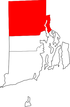 Map of Rhode Island highlighting Providence County | |
| Towns | ||
| CDPs | ||
| Other villages | ||
Providence (capital) | ||
| Topics |
| |
| Society |
| |
| Regions | ||
| Cities | ||
| Towns |
| |
| Authority control |
|
|---|