Natick, Massachusetts
Natick is a town in Middlesex County, Massachusetts, United States. It is near the center of the MetroWest region of Massachusetts, with a population of 32,786 at the 2010 census. 10 miles (16 km) west of Boston, Natick is part of the Greater Boston area. Massachusetts's center of population in 2000 and 2010 was in Natick.[2] A 2014 census showed its population at 34,230, meaning that between 2010 and 2014 it grew 3.6%, making it one of the Boston area's fastest-growing towns.[3]
Natick, Massachusetts | |
|---|---|
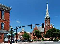 Natick center | |
 Seal | |
| Nickname(s): Home of Champions | |
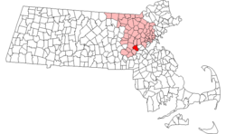 Location in Middlesex County in Massachusetts | |
| Coordinates: 42°17′00″N 71°21′00″W | |
| Country | United States |
| State | Massachusetts |
| County | Middlesex |
| Settled | 1651 |
| Incorporated | 1781 |
| Government | |
| • Type | Representative town meeting |
| Area | |
| • Total | 16.1 sq mi (41.6 km2) |
| • Land | 15.1 sq mi (39.1 km2) |
| • Water | 1.0 sq mi (2.5 km2) |
| Elevation | 181 ft (55 m) |
| Population (2017) | |
| • Total | 35,287[1] |
| • Density | 2,171.3/sq mi (838.5/km2) |
| Time zone | UTC−5 (Eastern) |
| • Summer (DST) | UTC−4 (Eastern) |
| ZIP Code | 01760 |
| Area code(s) | 508 / 774 |
| FIPS code | 25-43895 |
| GNIS feature ID | 0619407 |
| Website | www.natickma.gov |
Name
The name Natick comes from the language of the Massachusett Native American tribe and is commonly thought to mean "Place of Hills."[4] A more accurate translation may be "place of [our] searching," after John Eliot's successful search for a location for his Praying Indian settlement.[5]
History
Natick was first settled in 1651 by John Eliot, a Puritan missionary born in Widford, Hertfordshire, England, who received a commission and funds from England's Long Parliament to settle the Massachusett Indians called Praying Indians on both sides of the Charles River, on land deeded from the settlement at Dedham. Natick was the first of Eliot's network of praying towns and served as their center for a long time. While the towns were largely self-governing under Indian leaders, such as Waban and Cutshamekin, the praying Indians were subject to rules governing conformity to English Puritan culture (in practice Natick, like the other praying towns, evidenced a combination of traditional and English culture and practices). Eliot and Praying Indian translators printed America's first written Bible in the Algonquian language.[6][7]
The colonial government placed such settlements in a ring of villages around Boston as a defensive strategy. Natick was the first and best documented of them. The land was granted by the General Court as part of the Dedham Grant.
A school was set up, a government established, and the Indians were encouraged to convert to Christianity. In November 1675, during King Philip's War, the Natick Indians were sent to Deer Island. Many died of disease and cold, and those who survived found their homes destroyed. The Indian village did not fully recover, and the land held in common by the Indian community was slowly sold to white settlers to cover debts. By 1785, most of the Natick Indians had drifted away.
In 1775, both English and Praying Indian citizens of Natick participated in the Battles of Lexington and Bunker Hill, as well as serving in the Continental Army. The names of Natick's Praying Indian soldiers are memorialized on a stone marker, along with all of Natick's Revolutionary War veterans, on a stone marker on Pond Street, near downtown Natick.[8]
The town was officially incorporated in 1781. Henry Wilson, a U.S. senator who became the 18th Vice President of the United States (1873–1875), lived most of his life in Natick as a shoemaker and schoolteacher known as the "Natick Cobbler"[9] and is buried there. He is the namesake of one of Natick's middle schools.
Though Natick was primarily a farming town, the invention of the sewing machine in 1858 led to the growth of several shoe factories. The business flourished and peaked by 1880, when Natick, with 23 operating factories, was third in the nation in the quantity of shoes produced. The shoes made in Natick were primarily heavy work shoes with only one or two companies making lighter dress shoes. Natick was famous for its brogan (shoes), a heavy ankle-high boot worn by soldiers in the American Civil War.
The wound core for a more resilient baseball was developed by John W. Walcott and combined with the figure-eight stitching devised by Colonel William A. Cutler. It was manufactured by the firm of H. Harwood & Sons in their factory, the world's first plant for the manufacture of baseballs. In 1988 H. Harwood & Sons was converted into baseball factory condominiums.[10]
In 1874, a fire in downtown Natick demolished 18 business blocks, two shoe factories, the Town Hall, Natick's only fire engine house and the Congregational Church, as well as many private homes. Though no lives were lost, the loss of property was greater in proportion to the town's wealth than the Great Chicago Fire of 1871. In 1875, Natick's new Central Fire Station was completed on Summer Street and opened with grand ceremony on the same city block where the fire was first discovered. The Central Fire Station is now the home of The Center for Arts in Natick (TCAN), a private nonprofit performing arts center.
In 1891, a team from the town fire department won "The World’s Hook and Ladder Championship", a competition between the fire departments of four area towns. The victory gave the town its nickname "Home of Champions".[11]
Miles 8 through 12 of the Boston Marathon run through Natick on Patriots' Day every year along Route 135/Central St., and thousands of residents and visitors line the road to watch.
2010 Census data
- The median age of Natick according to the 2010 US census was 41.1 years.
- There were 15,777 male citizens, accounting for 48.1% of the total population.
- There were 17,009 female citizens, accounting for 51.9% of the population.
- There were 25,233 White or Caucasian citizens, accounting for 82.2% of the population.
- There were 3,714 Asian citizens, accounting for 8.3% of the population.
- There were 2,282 Hispanic or Latino citizens, accounting for 5.0% of the population.
- There were 2,995 Black or African American citizens, accounting for 6.6% of the population.
- There were 135 Native American and Alaska Native citizens, accounting for 0.4% of the population.
Geography and climate
According to the United States Census Bureau, the town has an area of 16.0 square miles (41 km2), of which 15.1 square miles (39 km2) is land and 1.0 square mile (2.6 km2) is water. The total area is 7.04% water, including Lake Cochituate and Dug Pond.
Natick borders Wellesley, Wayland, Weston, Framingham, Sherborn and Dover.
| Climate data for Natick, Massachusetts (1981−2010 normals) | |||||||||||||
|---|---|---|---|---|---|---|---|---|---|---|---|---|---|
| Month | Jan | Feb | Mar | Apr | May | Jun | Jul | Aug | Sep | Oct | Nov | Dec | Year |
| Average high °F (°C) | 33.7 (0.9) |
37.1 (2.8) |
46.2 (7.9) |
58.9 (14.9) |
68.8 (20.4) |
75.5 (24.2) |
81.5 (27.5) |
80.6 (27.0) |
73.7 (23.2) |
59.8 (15.4) |
51.6 (10.9) |
39.6 (4.2) |
58.9 (14.9) |
| Average low °F (°C) | 16.4 (−8.7) |
18.0 (−7.8) |
25.5 (−3.6) |
35.6 (2.0) |
45.0 (7.2) |
56.3 (13.5) |
62.1 (16.7) |
60.2 (15.7) |
51.7 (10.9) |
39.5 (4.2) |
31.8 (−0.1) |
21.9 (−5.6) |
38.7 (3.7) |
| Average precipitation inches (mm) | 3.41 (87) |
3.17 (81) |
4.03 (102) |
4.14 (105) |
3.91 (99) |
4.02 (102) |
3.80 (97) |
3.72 (94) |
3.83 (97) |
4.39 (112) |
4.28 (109) |
4.05 (103) |
46.77 (1,188) |
| Average snowfall inches (cm) | 15.8 (40) |
10.8 (27) |
7.8 (20) |
2.2 (5.6) |
0 (0) |
0 (0) |
0 (0) |
0 (0) |
0 (0) |
0 (0) |
1.6 (4.1) |
10.0 (25) |
48.2 (122) |
| Average precipitation days (≥ 0.01 in) | 10.3 | 9.2 | 10.3 | 11.1 | 12.4 | 11.3 | 9.8 | 9.7 | 9.0 | 10.2 | 11.0 | 10.7 | 125 |
| Average snowy days (≥ 0.1 in) | 5.4 | 3.8 | 2.6 | .4 | 0 | 0 | 0 | 0 | 0 | 0 | .7 | 3.4 | 16.3 |
| Source: NOAA[12] | |||||||||||||
Communities and neighborhoods

Natick Center
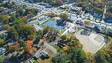
Natick Center, also known as Downtown Natick, is at the intersection of Central Street and Main Street and serves as the town's civic and cultural hub.
Many public services and public land use are downtown. Municipal buildings like the Natick Town Hall, Natick Fire Department, Natick Police Department and Morse Institute Library are there, along East Central Street. Also directly downtown is the Natick Town Common, where many town events and community activities are held. In the 1990s new downtown construction of a town hall, fire/police station, and enlargement to the library gave the downtown a fresh new look. New municipal buildings exist alongside several historic buildings and churches, the restored Central Fire House, several banks, restaurants and small businesses.
In 2012 the Massachusetts Cultural Council voted unanimously to make Natick Center one of the newest state-designated cultural districts, the tenth district to win this designation from the Commonwealth of Massachusetts. The Cultural Districts Initiative is designed to help communities attract artists and cultural enterprises, encourage business and job growth, expand tourism, preserve and reuse historic buildings, enhance property values, and foster local cultural development. Natick Center Cultural District is anchored by The Center for Arts in Natick,[13] Morse Institute Library and the Natick Common.
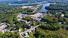
South Natick
South Natick, known for its scenic nature, is where the Native American settlers first arrived and began the town on the shores of the Charles River. Housing developers like Martin Cerel lived in South Natick, and thus refrained from building major tract neighborhoods in this part of town.
Most South Natick residents consider themselves to have a strong, separate cultural identity from the rest of Natick. It is the only community in Natick that can be separately addressed officially via the US Postal Office,[14] and street signage such as a sign along Route 16 coming from Wellesley communicates arrival in "So. Natick."
East Natick
East Natick is a community of Natick along Oak Street and at the intersection of Oak Street and Worcester Street. Notable landmarks include Jennings Pond, the Industrial Park on Oak St North, and the Lilja School. Longfellow Health Club, which features a gym, pool, and tennis courts, is in East Natick off Oak St. in the Industrial Park. The stretch of Route 9 in East Natick as one heads into Wellesley contains a multitude of ever-changing retail businesses.
West Natick
West Natick is a large section of Natick that borders the town of Framingham. The Natick Mall, as well as the strip mall called Sherwood Plaza with its office Industrial Park behind, are considered to be the commercial hub of West Natick. In addition to its retail development, post World War II housing developments like Westfield, Pelham, and Sherwood as well as the National Guard depot and a golf course on Speen St brought many people to this part of town.
There are many businesses in West Natick along West Central Street as well as another MBTA Commuter Rail station in addition to the one downtown. The area in West Natick, along Route 135 is the most densely populated section of town, with its thousands of condominiums and apartments clustered across the street from the train station.
Neighborhoods
Natick is a small town, and thus, the various sections of tract development homes are considered neighborhoods. These were houses built by several contractors in the late 1940s until the late 1950s. Listed here, are a few of these sections.
Sherwood
One of the earliest post World War II developments in West Natick, the homes are colonial in style, with street names reminiscent of the Robin Hood legend. The homes were built in 1948 and the neighborhood remains popular due to the fact that there's no through traffic, and most of the houses have been enlarged with additions.
Walnut Hill
Walnut Hill is a neighborhood north of downtown. It is known for the private boarding school Walnut Hill School for the Arts, as well as many Victorian era houses lining Walnut and Bacon Streets.
Wethersfield
The Wethersfield area of Natick is a residential neighborhood north of Route 9. It is a typical 1950s development of Campanelli ranch houses, and remains popular with first-time home buyers due to the relatively inexpensive slab-style houses. This area includes Drury Lane and all connecting roads within the boundaries of route 9, Pine Street, and Route 27.
Oak Street
South of Route 9, this section began as a summer vacation area, with tiny cottages surrounding Jennings Pond. Over the years, some houses were enlarged, but the area remains quaint and quiet with no thru traffic. On the westerly side of South Oak is a neighborhood of Cape style houses with streets named after World War II Generals. North of Route 9, other developments of small Cape-style homes were built in the early and mid-1950s and remain popular with first-time home buyers due to their affordability. There are two Industrial Parks along north Oak St that contain office buildings on one side of the road and larger warehouses on the eastern side.
Little South
Just south of the Natick Common, Cottage Street begins what is commonly called Little South, named so because of its proximity to South Natick. Little South nomenclature extends to the east portions of Everett Street, down to Eliot St. Homes along Cottage St. were primarily built in the early 1950s and are mostly modest and well-maintained. The best-known landmarks in Little South are a WWII monument dedicated to the fallen soldiers from Natick, and The Tobin School, a private daycare and elementary school that has two large, attractive buildings off of Cottage St. Everett St. has larger farm homes situated on generous lots. Eliot St., which runs parallel to the Charles River, has some of Natick's oldest and nicest homes. Just before South Natick begins, there is a beautiful Virgin Mary statue on a large rock on the south side of the Charles River, enveloped by graceful pine trees.
Demographics
| Historical population | ||
|---|---|---|
| Year | Pop. | ±% |
| 1850 | 2,744 | — |
| 1860 | 5,515 | +101.0% |
| 1870 | 6,404 | +16.1% |
| 1880 | 8,112 | +26.7% |
| 1890 | 9,118 | +12.4% |
| 1900 | 9,488 | +4.1% |
| 1910 | 9,866 | +4.0% |
| 1920 | 10,907 | +10.6% |
| 1930 | 13,589 | +24.6% |
| 1940 | 13,851 | +1.9% |
| 1950 | 19,838 | +43.2% |
| 1960 | 17,993 | −9.3% |
| 1970 | 31,057 | +72.6% |
| 1980 | 29,461 | −5.1% |
| 1990 | 30,510 | +3.6% |
| 2000 | 31,868 | +4.5% |
| 2010 | 32,786 | +2.9% |
| 2014 | 34,230 | +4.4% |
As of the census[15] of 2010, there were 32,786 people, 13,080 households, and 8,528 families residing in the town. The population density was 2,132.9 people per square mile (823.7/km2). There were 13,368 housing units at an average density of 886.3 per square mile (342.3/km2). The racial makeup of the town was 85.4% White, 2% African American, 0.1% Native American, 7.2% Asian, 0.0% Pacific Islander, 0.5% from other races and 2% from two or more races. Hispanic or Latino of any race were 3% of the population.
There were 13,080 households out of which 30.3% had children under the age of 18 living with them, 54.5% were married couples living together, 8.2% had a female householder with no husband present, and 34.8% were non-families. 28.3% of all households were made up of individuals and 9.8% had someone living alone who was 65 years of age or older. The average household size was 2.42 and the average family size was 3.02.
In the town, the population was spread out with 23.0% under the age of 18, 5.1% from 18 to 24, 34.3% from 25 to 44, 23.3% from 45 to 64, and 14.3% who were 65 years of age or older. The median age was 38 years. For every 100 females, there were 89.7 males. For every 100 females age 18 and over, there were 85.3 males.
According to a 2007 estimate,[16] the median income for a household in the town was $61,855, and the median income for a family was $85,056. Males had a median income of $51,964 versus $41,060 for females. The per capita income for the town was $36,358. About 1.7% of families and 2.8% of the population were below the poverty line, including 2.4% of those under age 18 and 5.3% of those age 65 or over.
Natick is surrounded, on three sides, by five of the eleven most affluent towns in Massachusetts[17] with Wayland to the north, Weston to the northeast, Wellesley to the east, Dover to the southeast, and Sherborn to the southwest.
Government
Town
Natick has representative town meeting form of government (consisting of 180 members) with a Board of Selectmen and a Town Administrator.[18] The members of the Board and the dates their terms end are (as of March 2019):
- Michael J. Hickey, Jr., Chair, 2020;
- Susan Salamoff, Vice Chair, 2022;
- Jonathan Freedman, Clerk, 2021;
- Richard P. Jennett, Jr., 2022;
- Karen Adelman-Foster, 2020.
County
Mismanagement of Middlesex County's public hospital in the mid-1990s left the county on the brink of insolvency, and in 1997 the Massachusetts legislature stepped in by assuming all assets and obligations of the county. The government of Middlesex County was officially abolished on July 11, 1997. The sheriff and some other regional officials with specific duties are still elected locally to perform duties within the county region, but there is no county council or commissioner. Communities are now granted the right to form their own regional compacts for sharing services.
These are the remaining elected officers for Middlesex County:
- Clerk of Courts: Michael A. Sullivan
- County Treasurer: Position Eliminated
- District Attorney: Marian Ryan
- Register of Deeds: Richard P. Howe, Jr. (North at Lowell), Maria C. Curtatone (South at Cambridge)
- Register of Probate: Tara E. DeCristofaro
- County Sheriff: Peter Koutoujian
Education
Public schools
The Natick Public School District operates the following schools:[19]
- High school:
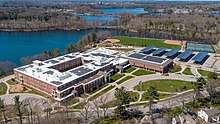
- Natick High School; The High School building on the shore of Dug Pond, was opened in 2012.[20] The new building design is based on a model approved by the state of Massachusetts. This was necessary in order to maximize state reimbursement for design and construction. It cost $80 million. The new high school is adjacent to the old high school and opened to students on August 29, 2012. Natick High's former school mascot name, the "Redmen", was changed in 2009 to the "Red and Blue", then in 2012 to the "Redhawks", also spelled "Red Hawks".
- Middle schools:
- Kennedy Middle School, for which a replacement building broke ground on March 27, 2019;
- Wilson Middle School.
- Elementary schools:
- Brown Elementary School;
- Lilja Elementary School;
- Memorial Elementary School;
- Bennett-Hemenway (Ben-Hem) Elementary School;
- Johnson Elementary School;
Private schools
- Walnut Hill School for the Arts
- The Riverbend School (formerly Eliot Montessori School)[21]
- The Tobin School
- Brandon School and Residential Treatment Center, a school within a residential treatment center
Transportation
Natick Center station, in the downtown area, is served by the MBTA Commuter Rail Framingham/Worcester Line.
Bus service is provided in Natick by the MetroWest Regional Transit Authority.
Notable people
- Horatio Alger, Jr., minister, author of children's books with a rags to riches theme, settled in Natick in 1860 and built his family home in South Natick.
- Thomas S. Allen, American composer.
- James Bamford, author, journalist who writes about the world of US intelligence agencies.
- John Carlson, NHL player for the Washington Capitals.
- Eddie Casey, former American football player and coach.
- David Cullen, Artist in Residence at Elizabethtown College and Grammy Award-winning guitarist
- William Finn, Tony-winning composer and lyricist of musicals including Falsettos and The 25th Annual Putnam County Spelling Bee.
- Edward S. Donovan, American sprinter.
- William F. Donovan, track coach at Harvard.
- Keene Fitzpatrick, track coach at Yale, Michigan and Princeton, 1890–1932.
- Darren Flutie, CFL and NFL veteran who attended Natick High School before going to Boston College; 2nd all-time in receptions in the CFL; CFL Hall of Famer.
- Doug Flutie, NFL and CFL veteran who attended high school in Natick, before going to Boston College; retired from the New England Patriots after the 2005–06 season; resides in Natick, 50th Heisman Trophy winner; also played for many other NFL teams, including the Buffalo Bills.
- Anjali Forber-Pratt, wheelchair racer and Paralympian.
- Alison Fraser, Broadway performer and two-time Tony Award nominee grew up in Natick; graduated from Natick High School.
- Alan Gordon, songwriter perhaps notable for writing "Happy Together" by the Turtles.
- Alfred S. Hartwell (1836–1912), commanded the 55th Massachusetts Infantry Regiment, sister regiment of the 54th Massachusetts Infantry, during the Civil War. Led Union troops into Charleston, South Carolina when it fell and worked for the Freedman's Bureau. Moved to the Kingdom of Hawaii in 1868 and was appointed Chief Justice of the Hawaiian Supreme Court.
- Walt Hriniak, Major League Baseball player and batting coach.
- Harold Kushner, rabbi and author of many books, known for When Bad Things Happen to Good People.
- Harvey Leonard, chief meteorologist for WCVB-TV.
- Dan LaCouture, grew up and went to school in Natick and played hockey for BU. Drafted into the NHL 1996; played for the Edmonton Oilers, Pittsburgh Penguins, New York Rangers, Boston Bruins, New Jersey Devils, Carolina Hurricanes.
- Dottie Green, female catcher who played from 1943 through 1947 in the All-American Girls Professional Baseball League.[22]
- Ted Martin, founder of the International Snowboard Federation.
- Meg Mallon, professional golfer on the LPGA Tour and twice winner of the US Women's Open.
- Joe McGlone, American football player.
- Mike Murphy (trainer and coach), trainer and coach at Yale.
- Don Nardo, historian, composer, and writer.
- William Nutt, moved to Natick in 1856, went to Kansas to oppose pro-slave forces there in 1858 and was an organizer of the Natick Shoe Strike in 1860. Served with the 55th Massachusetts Infantry during the Civil War and rose to the rank of Colonel.
- John O'Hurley, actor best known for role as J. Peterman on Seinfeld.
- Al Parker, gay porn actor, producer, and director.
- Rob Patterson, former guitarist for Otep, touring guitarist for Korn, currently guitarist for Filter (band) and engaged to Carmen Electra.
- Rene Rancourt, professional singer, sang the national anthem at all home Boston Bruins hockey games.
- Jonathan Richman, proto-punk rock icon and founder of The Modern Lovers.
- Jim Riley, graduated from Natick High School and went on to become drummer and band leader for the award-winning country band Rascal Flatts.
- John Sassamon, English-speaking praying Indian who assisted John Eliot (missionary) as interpreter.
- Phil Schiller, senior vice president of worldwide marketing at Apple Inc.
- Pete Smith, pitcher for Seattle Rainers and Boston Red Sox in 1961.
- Harriet Beecher Stowe (June 14, 1811 – July 1, 1896), author and abolitionist, whose novel Uncle Tom's Cabin (1852) attacked the cruelty of slavery and received worldwide acclaim. Her novel "Old Town Folks" was written while she was living in Natick and tells the story of her husband's family.
- Don Terry (1902–1988), film actor.
- Alexander Wheelock Thayer, US consul at Trieste in 1859 and author of a biography of Ludwig van Beethoven published in 1866.
- Ming Tsai, American restaurateur, television personality, and celebrity chef.
- Frank Varrichione (born 1932), college All-American and five-time Pro Bowl professional football player.[23]
- Waban, 17th-century tribal chief.
- Sara Whalen (born 1976), Olympic soccer silver medalist.
- Sarita White, contestant on reality show "Survivor: Redemption Island".
- Fred Willis, former NFL player.
- Henry Wilson, the 18th Vice President of the United States, lived at 33 West Central Street and worked as a shoemaker at his shoe shop at 181 West Central Street.[24]
- Ida E. Woods (1870-1940), astronomer, born and died in Natick.
Points of interest
- The Bacon Free Library, which opened in 1881, is located at 58 Eliot Street. This building was a gift to the community under the will of Oliver Bacon, who died in 1878. It has been operating as a public library ever since. The library overlooks the Charles River in South Natick. The Natick Historical Society resides in the lower portion of the building.
- Temple Israel of Natick, Natick's oldest synagogue, is located on Hartford Street. Founded in 1944, it is an egalitarian Conservative synagogue.[25] It is the largest Conservative synagogue in the area, and serves many communities in the Metro West area. Harold Kushner was its rabbi for over two decades.
- The Natick Historical Society, located in the lower level of the Bacon Free Library. Archives and exhibits on John Eliot and Praying Indians, natural history collections, life during colonial times, early republic and industrial revolution, memorabilia of famous Natick citizens.
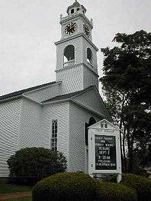
- Eliot Church, founded as a meetinghouse in 1651, is the fifth structure on the site. The present church dates from the 1830s. A sign erected in front of the church in 1930, on the 300th anniversary of the founding of the Massachusetts Bay Colony, reads,"INDIAN MEETINGHOUSE – On this site John Eliot helped his Indian converts to build their first meetinghouse in 1651, with a 'prophet's chamber' where he lodged on his fortnightly visits to preach to them in their language. His disciple Daniel Takawambait succeeded to the pastoral office in 1698."
- The U.S. Army Soldier Systems Center (SSC) (Also known as The Natick Army Labs), a complex of military R&D facilities, produces military-use items such as field rations, personal protective field equipment, and specialized uniforms.
- Natick Mall is the largest shopping center in New England. First opened in 1966, it was replaced by the current building in 1994. A major renovation took place in 2007.
- Cognex Corporation corporate headquarters.
- MathWorks corporate headquarters, which is split into two campuses, Lakeside and Apple Hill. The Lakeside campus was formerly the site of Boston Scientific headquarters and of mini-computer manufacturer Prime Computer. Before Prime, Carling ran a Black Label brewery there.
- The Walnut Hill School is a private secondary school, offering particular emphasis in the studio and performing arts. Walnut Hill graduates more students to the Juilliard School than any other secondary school in the world.
- The Center for Arts in Natick (TCAN), located in Natick's historic Central Fire Station, is a performance venue for musicians in jazz, folk, classical, and rock genres. TCAN also hosts theatrical productions by the TCAN Players and children's classes in theatre and dance. A cinema on the restored second floor shows new releases and classic films. Artists performing at TCAN have included Judy Collins, Don McLean, George Winston, Paula Poundstone, Shawn Colvin, Marshall Crenshaw, Jimmy Webb, Karla Bonoff, John Sebastian and Adrian Belew.
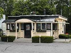
- Casey's Diner, constructed in 1922, is one of the oldest operating ten-stool diners in the United States. Casey's Diner is diminutive in size at only 10 feet (3.0 m) by 20-1/2 feet, and was constructed by the Worcester Lunch Car Company in Worcester, Massachusetts. Famous for its steamed hot dogs, Casey's originated as a horse-drawn lunch wagon that was parked on Natick Common.
- The Boden Lane Cemetery is a very small burial site established in 1815. Although the cemetery was established in that year, many of the gravestones are dated even earlier than this date, with some dating back to the Revolutionary War. The cemetery is located on Boden Lane, to the right of Beaver Dam, and directly across the street from the Chabad Center of Natick.
- The Natick Community Organic Farm, located in South Natick on conservation land. It is a certified-organic, fully functioning working open year-round with no admission fee for the public's visits and purchases. The farm welcomes volunteers and runs a number of hands-on educational programs for adults and children. The farm has a barn built in 1815, a timber-framed nature center, two greenhouses, two hoophouses, four acres of market gardens, bee hives, woodland walking trails, a composting toilet, and a host of animals including chickens, turkeys, pigs, rabbits, sheep, goats, and cows.
- Henry Wilson Shoe Shop, 181 West Central Street, listed on the National Register of Historic Places
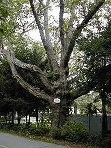
- The station tree is a 500-year-old black oak that the original surveyors used to mark the boundary between Natick and what was then part of Needham. That boundary is now the Natick-Weston town line on Winter Street, near the campus of The Rivers School in Weston, MA. One other notable landmark tree—the Eliot Oak next to the Eliot Church in South Natick—was removed in 1936 after the installation of underground gas lines damaged the root system, ultimately killing it.
- The Chabad Center in Natick is a synagogue and Jewish educational center which is dedicated to strengthening Jewish awareness in the Metrowest area. The Hebrew School for the Arts is a breakthrough in typical Hebrew school education. Located at the Chabad Center, Hebrew School for the Arts teaches traditional Judaism while integrating the modern arts of drama.
- Sassamon Trace Golf Course, built atop the former town landfill, is a branch of the Natick Recreation Department.
- Natick's Recycle Center, adjacent to the town-owned golf course, and the high school athletic fields, serves the town's recycle needs.
- St. Patrick's Church, located in Natick center, is Natick's tallest structure, and is also the largest Roman Catholic Parish in Natick.[26]
In popular culture
Natick appears on the Family Guy episode "Da Boom" when the family sets out to the town after Peter reveals that there is a Twinkie factory there (Natick did contain a Hostess factory until 2007 when the Natick Mall expanded into the collection). He eventually starts a town on the ruins of the community, naming it New Quahog.[27][28]
To solvers of crossword puzzles such as those of the New York Times and Los Angeles Times, natick (as coined by Michael Sharp, alias Rex Parker) refers to any square a solver cannot fill in correctly without guessing because the solver does not know either entry that passes through it (and there are at least two letters that are reasonable guesses). Such entries are generally proper nouns.[29][30][31]
Scenes included in the 2013 American drama film Labor Day (film) starring Kate Winslet, Josh Brolin and Tobey Maguire were filmed in Natick, at locations including The Center for Arts in Natick and Park Street Ice Cream.
Natick appears in the 2015 video game Fallout 4, which is set in the greater Boston area (referred to in the game as The Commonwealth).
Part of South Natick made an appearance in the Oscar-nominated movie Knives Out. While filming on location, the project had the code name “Morning Bell.” Other scenes were shot in surrounding towns such as Wellesley and Waltham.[32][33]
In April 2019 Chris Evans was in Natick filming an upcoming TV series, “Defending Jacob.” The production was seen filming on the Natick Common, Park Street, and at Park Street Ice Cream. The ice cream shop was temporarily converted into “K.D. Scoops” for the filming. Many Natick residents crowded around in hopes of getting a glimpse of Evans. Photos were taken of him and his co-star sitting on a bench on the commons as well as inside and outside Park Street Ice Cream. “Defending Jacob” will be released on Apple TV+ on April 24, 2020.[34]
References
- "Zip Code 01760 - 2010 Census for Natick, MA".
- "Centers of Population". The United States Census Bureau. US Department of Commerce. Retrieved 21 April 2020.
- "Natick MA Demographics data".
- "Eliot Indians". Natick Historical Society. Archived from the original on 2015-03-21. Retrieved 2014-11-18.
- Tooker, William Wallace (Sep 1897). "The Significance of John Eliot's Natick" (PDF). American Anthropologist. 10 (9): 281–287. doi:10.1525/aa.1897.10.9.02a00000. JSTOR 658500.
- John Eliot Bible, 1st Ed. 1663, From Natick Historical Society Collection
- "The Eliot Indian Bible: First Bible Printed in America Archived 2012-03-19 at the Wayback Machine." Library of Congress Bible Collection. Library of Congress, n.d. Web. 5 Sep 2011.
- Massachusetts Soldiers and Sailors of the Revolutionary War
- James M. McPherson, Battle Cry of Freedom: The Civil War Era (New York: Bantam Books, 1989), p. 139.
- "Baseball Factory Condominiums".
- "Natick: Home of Champions". Natick Historical Society. Retrieved 2020-06-10.
- "NowData - NOAA Online Weather Data". National Oceanic and Atmospheric Administration. Retrieved 2013-02-09.
- "TCAN made believers out of Natick". Boston Globe. 6 October 2017.
- "USPS.com® - ZIP Code™ Lookup".
- "American FactFinder". United States Census Bureau. Archived from the original on 2016-03-07. Retrieved 2016-02-23.
- "Natick town, Middlesex County, Massachusetts – Fact Sheet – American FactFinder". Factfinder.census.gov. Archived from the original on February 2, 2009. Retrieved January 27, 2011.
- Massachusetts locations by per capita income
- Town of Natick (December 7, 2016). "Town of Natick – Board Of Selectmen/Town Administrator". Natickma.gov. Retrieved December 7, 2016.
- "Natick Public Schools". Archived from the original on 2007-07-25.
- Benson, Brian. "Natick High grad kicks off school demolition". Daily News.
- "Two Montessori schools to merge in Natick". The MetroWest Daily News. April 10, 2010. Archived from the original on April 7, 2012. Retrieved November 30, 2011.
- "Dottie Green, 1945 Rockford Peaches". Flickr - Photo Sharing!. Retrieved 2016-04-25.
- "Frank Varrichione: Career Stats," National Football League, www.nfl.com/
- http://natickhistoricalsociety.org/figures/
- "Welcome to Temple Israel of Natick!". 6 August 2014.
- "カードローン申し込みから利用までの流れについて". Archived from the original on 2015-03-13. Retrieved 2013-11-29.
- Turchi, Megan (February 23, 2015). "7 Things You Probably Didn't Know About Natick". Boston.com. Retrieved 26 January 2016.
- Abelson, Jenn; Finaldi, Laura (November 17, 2012). "With Hostess closing, gold rush is on for endangered Twinkies". Boston Globe. Retrieved 26 January 2016.
- Sharp, Michael (July 6, 2008). "Sunday, July 6, 2008". Rex Parker Does the NY Times Crossword Puzzle. Retrieved June 20, 2012.
- Amlen, Deb (March 22, 2011). "Wednesday: It May Have a Square in the Middle". New York Times "Wordplay" blog. Retrieved June 20, 2012.
- "Crossword Corner Abbr". February 15, 2012. Retrieved July 5, 2015.
- https://theswellesleyreport.com/2018/12/knives-out-movie-being-shot-in-wellesley-now/
- https://www.thecinemaholic.com/where-was-knives-out-filmed/
- https://www.metrowestdailynews.com/photogallery/WL/20190412/NEWS/411009971/PH/1
External links
| Wikimedia Commons has media related to Natick, Massachusetts. |
| Wikivoyage has a travel guide for Natick. |
| Wikisource has the text of The New Student's Reference Work article "Natick, Mass.". |
Municipalities and communities of Middlesex County, Massachusetts, United States | ||
|---|---|---|
| Cities | 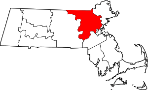 | |
| Towns |
| |
| CDPs | ||
| Other villages |
| |
| Authority control |
|
|---|