Newton, New Hampshire
Newton is a town in Rockingham County, New Hampshire, United States. The population was 4,603 at the 2010 census.[1]
Newton, New Hampshire | |
|---|---|
 Seal | |
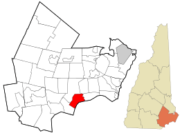 Location in Rockingham County and the state of New Hampshire. | |
| Coordinates: 42°52′10″N 71°02′04″W | |
| Country | United States |
| State | New Hampshire |
| County | Rockingham |
| Incorporated | 1749 |
| Villages | Newton Newton Junction Rowes Corner Sargent Corners |
| Government | |
| • Board of Selectmen | Lisa Gonyer, Chair James L. Doggett Lawrence Foote Matthew A. Burrill Kate Michaels |
| • Town Administrator | Nancy J. Wrigley |
| Area | |
| • Total | 10.1 sq mi (26.1 km2) |
| • Land | 9.9 sq mi (25.7 km2) |
| • Water | 0.2 sq mi (0.4 km2) 1.59% |
| Elevation | 194 ft (59 m) |
| Population (2010) | |
| • Total | 4,603 |
| • Density | 460/sq mi (180/km2) |
| Time zone | UTC-5 (Eastern) |
| • Summer (DST) | UTC-4 (Eastern) |
| ZIP code | 03858 |
| Area code(s) | 603 |
| FIPS code | 33-52900 |
| GNIS feature ID | 0873685 |
| Website | www |
History

The sixth town to be granted from the Masonian land purchase of 1746, Newton was originally part of Salisbury, Massachusetts; later, part of Amesbury, Massachusetts; then part of the West Parish of Amesbury; then part of New Town or South Hampton, Massachusetts (now South Hampton, New Hampshire). A number of the residents felt they were too far away from its church for their convenience, and the town was incorporated by Colonial Governor Benning Wentworth as Newtown in 1749, simply because it was a new town. In 1846, the New Hampshire legislature voted to contract the name to Newton.
Geography
According to the United States Census Bureau, the town has a total area of 10.1 square miles (26.2 km2), of which 9.9 sq mi (25.6 km2) is land and 0.2 sq mi (0.5 km2) is water, comprising 1.59% of the town. The highest point in Newton is the summit of Brandy Brow Hill, at 289 feet (88 m) above sea level, located directly upon the southern corner of the town.
Villages or place names in the town include Newton, Newton Junction, Rowes Corner, Sargent Corners, and Crane Crossing.
Adjacent municipalities
- Kingston, New Hampshire (north)
- East Kingston, New Hampshire (northeast)
- South Hampton, New Hampshire (east)
- Merrimac, Massachusetts (southeast)
- Plaistow, New Hampshire (southwest)
Demographics
| Historical population | |||
|---|---|---|---|
| Census | Pop. | %± | |
| 1790 | 530 | — | |
| 1800 | 450 | −15.1% | |
| 1810 | 454 | 0.9% | |
| 1820 | 477 | 5.1% | |
| 1830 | 510 | 6.9% | |
| 1840 | 541 | 6.1% | |
| 1850 | 685 | 26.6% | |
| 1860 | 850 | 24.1% | |
| 1870 | 856 | 0.7% | |
| 1880 | 1,606 | 87.6% | |
| 1890 | 1,064 | −33.7% | |
| 1900 | 924 | −13.2% | |
| 1910 | 962 | 4.1% | |
| 1920 | 872 | −9.4% | |
| 1930 | 848 | −2.8% | |
| 1940 | 900 | 6.1% | |
| 1950 | 1,173 | 30.3% | |
| 1960 | 1,419 | 21.0% | |
| 1970 | 1,920 | 35.3% | |
| 1980 | 3,068 | 59.8% | |
| 1990 | 3,473 | 13.2% | |
| 2000 | 4,289 | 23.5% | |
| 2010 | 4,603 | 7.3% | |
| Est. 2017 | 4,913 | [2] | 6.7% |
| U.S. Decennial Census[3] | |||
As of the census[4] of 2000, there were 4,289 people, 1,518 households, and 1,170 families residing in the town. The population density was 433.0 people per square mile (167.1/km²). There were 1,552 housing units at an average density of 156.7 per square mile (60.5/km²). The racial makeup of the town was 97.90% White, 0.68% African American, 0.16% Native American, 0.07% Asian, 0.02% Pacific Islander, 0.40% from other races, and 0.77% from two or more races. Hispanic or Latino of any race were 1.31% of the population.
There were 1,518 households out of which 40.7% had children under the age of 18 living with them, 66.1% were married couples living together, 7.2% had a female householder with no husband present, and 22.9% were non-families. 15.8% of all households were made up of individuals and 5.6% had someone living alone who was 65 years of age or older. The average household size was 2.83 and the average family size was 3.19.
In the town, the population was spread out with 28.8% under the age of 18, 5.8% from 18 to 24, 36.2% from 25 to 44, 21.6% from 45 to 64, and 7.6% who were 65 years of age or older. The median age was 35 years. For every 100 females, there were 99.1 males. For every 100 females age 18 and over, there were 98.1 males.
The median income for a household in the town was $60,972, and the median income for a family was $62,271. Males had a median income of $43,510 versus $32,471 for females. The per capita income for the town was $22,910. About 2.7% of families and 4.0% of the population were below the poverty line, including 3.4% of those under age 18 and 16.0% of those age 65 or over.
Notable people
- Bill Moisan, World War II decorated veteran and pitcher with the Chicago Cubs
- Mark Mowers, centre with the Boston Bruins[5]
- Mike Ryan, catcher and coach with the Boston Red Sox, Philadelphia Phillies, and Pittsburgh Pirates[6]
Sites of interest
- Marshall House
- Village Primary School (1850) - Newton Historical Society, which was established on March 26, 1973, holds its monthly meetings at this location[7]
References
- United States Census Bureau, U.S. Census website, 2010 Census figures. Retrieved March 23, 2011.
- "Annual Estimates of the Resident Population: April 1, 2010 to July 1, 2017 (PEPANNRES): Minor Civil Divisions – New Hampshire". Archived from the original on February 13, 2020. Retrieved November 15, 2018.
- "Census of Population and Housing". Census.gov. Retrieved June 4, 2016.
- "U.S. Census website". United States Census Bureau. Retrieved 2008-01-31.
- NHL's new financial structure has local players job hunting in Europe Retrieved 2018-08-26.
- Williams, Dave. "Mike Ryan". Society for American Baseball Research. Retrieved June 10, 2017.
- "Newton Historical Society". Retrieved August 11, 2014.
External links
- Town of Newton official website
- New Hampshire Economic and Labor Market Information Bureau Profile
- "A brief history of Newton, NH: A New Chronology of the Life & Times of Jonathan Farren", by Jerry Ferrin
Places adjacent to Newton, New Hampshire | |
|---|---|
Municipalities and communities of Rockingham County, New Hampshire, United States | ||
|---|---|---|
| City | 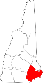 Map of New Hampshire highlighting Rockingham County | |
| Towns |
| |
| CDPs | ||
| Other villages | ||
| Authority control |
|
|---|