Waterford, Virginia
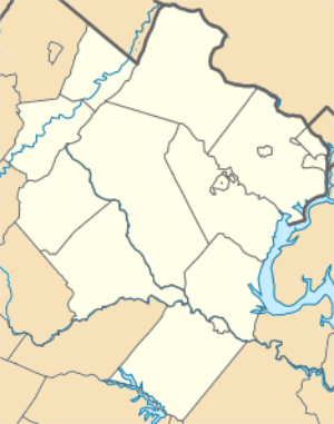
Waterford is an unincorporated village in the Catoctin Valley of Loudoun County, Virginia, located along Catoctin Creek. Waterford is 47 miles (76 km) northwest of Washington, D.C., and 7 miles (11 km) northwest of Leesburg. The entire village and surrounding countryside is a National Historic Landmark District, noted for its well-preserved 18th and 19th-century character.
Waterford, Virginia | |
|---|---|
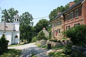
 The Waterford town center in July 2008 | |
 Waterford, Virginia  Waterford, Virginia  Waterford, Virginia | |
| Coordinates: 39°11′12″N 77°36′36″W | |
| Country | |
| State | |
| County | |
| Time zone | UTC−5 (Eastern (EST)) |
| • Summer (DST) | UTC−4 (EDT) |
| ZIP codes | 20197 |
Waterford Historic District | |
 The Waterford Mill | |
| NRHP reference No. | 69000256 |
|---|---|
| VLR No. | 401-0123 |
| Significant dates | |
| Added to NRHP | June 3, 1969[1] |
| Designated NHLD | April 15, 1970[2] |
| Designated VLR | May 13, 1969[3] |
In the 1810 United States Census, the population center of the United States was recorded as being just northwest of the village.[4]
History
Founding
Waterford was established around 1733 by Amos Janney, a Quaker from Bucks County, Pennsylvania. Janney purchased 400 acres (1.6 km2) on the south fork of Catoctin Creek and established a grist mill and saw mill in the area in the 1740s. Due to the success of the mills, the settlement became known as "Janney's Mill". The town grew quickly as a center of commerce for growers of grain. [5]
Growth
Amos Janney died in 1747, leaving his estate to his sixteen-year-old son, Mahlon. Mahlon replaced the original log mill with a two-story structure. The village continued to grow, and in 1780, 12 acres (49,000 m2) on the south side of Main Street were subdivided into 15 lots, upon which shops and homes were built. By the 1790s, the village was known as Waterford, named after the city of Waterford, in Ireland, where some of its founders had once lived before immigrating to the United States. New residents continued to come from Pennsylvania, as Quakers were followed by Presbyterians, Lutherans, Baptists, and Methodists. Waterford was also populated by African-Americans, both free and enslaved.[6]
Civil War
By the start of the Civil War, the population of Waterford remained largely Quaker. As pacifists and abolitionists,[7] the Quakers remained loyal to the Union throughout the war. Waterford was the scene of a fierce fight between the county's Unionist and Confederate partisan units, the Loudoun Rangers and White's Rebels, respectively. In those days, it was the home for mostly Quakers who helped slaves escape to the North.
Waterford today
After falling into disrepair in the early part of the 20th century, the Waterford Foundation was formed to help save and preserve Waterford and its history.[8] In 1974, the Waterford Foundation helped create an innovative land preservation program in which the historic properties of Waterford are protected through open space and façade easements. More than 60 easements have been granted.[8]
The town today is largely residential, although a number of businesses are based in the village. The Loudoun Mutual Insurance Company has been located in Waterford since 1849.[9]
National Historic Landmark
The village was listed as a Virginia Historic Landmark in 1969.[10] Waterford and a significant portion of its surrounding countryside was declared a National Historic Landmark in 1970.[2] The designation was made in recognition of the town's well-preserved 18th and 19th-century architecture and landscape.[11] Significant buildings include the mill (circa 1750), Arch House Row (circa 1750), Camelot School (circa 1800), the Hague-Hough house, which is Waterford's oldest house (circa 1740), and the 1882 Presbyterian church.[11]
The Catoctin Creek Bridge was listed on the National Register of Historic Places in 1974, and the William Virts House was listed in 2011.[12][13]
See also
References
- "National Register Information System". National Register of Historic Places. National Park Service. January 23, 2007.
- "Waterford Historic District". National Historic Landmark summary listing. National Park Service. Retrieved 2008-04-21.
- "Virginia Landmarks Register". Virginia Department of Historic Resources. Retrieved 5 June 2013.
- "2000 U.S. Population Centered in Missouri". National Atlas of the United States. 2001-04-02. Retrieved 2014-09-27.
- "Quakers in Waterford". Waterford Foundation. Retrieved 15 February 2017.
- "Rapid Growth". Waterford Foundation. Retrieved 15 February 2017.
- "Coral Gables Senior High". Retrieved 9 February 2017.
- Ridgway Khalifa, Daisy (November 22, 2010). "A Different World". Virginia Living. Cape Fear Publishing. Retrieved June 27, 2016.
- "Our history". Loudoun Mutual Insurance Company. Retrieved 15 February 2017.
- Staff, Virginia Historic Landmarks Commission, James W. Moody, Jr., Director (May 23, 1969), National Register of Historic Places Inventory-Nomination: Waterford Historic District (PDF), National Park ServiceCS1 maint: multiple names: authors list (link) (with property zone map and more)
- Staff, Virginia Historic Landmarks Commission, James W. Moody, Jr., Director (May 23, 1969), National Register of Historic Places Inventory-Nomination: Waterford Historic District (PDF), National Park ServiceCS1 maint: multiple names: authors list (link) and Accompanying 16 photos, from 1969 (32 KB)
- "National Register Information System". National Register of Historic Places. National Park Service. July 9, 2010.
- "National Register of Historic Places Listings". Weekly List of Actions Taken on Properties: February 2011. National Park Service. 2011-03-04.
External links
| Wikimedia Commons has media related to Waterford, Virginia. |
- Waterford Citizens' Association
- The Waterford Foundation
- Waterford History
- Waterford, Virginia: From Mill Town to National Historic Landmark, a National Park Service Teaching with Historic Places (TwHP) lesson plan
- Waterford Historic District map at Virginia DHR
- Waterford Historic District, Loudoun County, 4 photos at Virginia DHR
- Historic American Buildings Survey (HABS) No. VA-1042, "Town of Waterford (General Views), Waterford, Loudoun County, VA", 5 photos, and about 39 other records for individual structures
Municipalities and communities of Loudoun County, Virginia, United States | ||
|---|---|---|
| Towns | 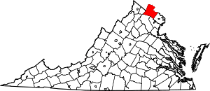 Map of Virginia highlighting Loudoun County | |
| CDPs | ||
| Unincorporated communities |
| |
| Former | ||
