National Register of Historic Places listings in Brunswick County, Virginia
This is a list of the National Register of Historic Places listings in Brunswick County, Virginia.
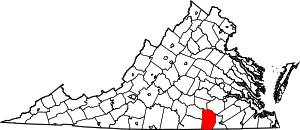
Location of Brunswick County in Virginia
This is intended to be a complete list of the properties and districts on the National Register of Historic Places in Brunswick County, Virginia, United States. The locations of National Register properties and districts for which the latitude and longitude coordinates are included below, may be seen in a Google map.[1]
There are 11 properties and districts listed on the National Register in the county. Another property was once listed but has been removed.
- This National Park Service list is complete through NPS recent listings posted June 19, 2020.[2]
Current listings
| [3] | Name on the Register[4] | Image | Date listed[5] | Location | City or town | Description |
|---|---|---|---|---|---|---|
| 1 | Brick House | 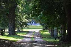 Brick House |
July 8, 1982 (#82004544) |
Brodnax Rd. 36°38′58″N 77°59′14″W |
White Plains | |
| 2 | Brunswick County Courthouse Square | .jpg) Brunswick County Courthouse Square |
December 31, 1974 (#74002110) |
202, 216, 228, and 234 N. Main St. 36°45′31″N 77°50′48″W |
Lawrenceville | |
| 3 | Church Home for Aged, Infirm and Disabled Colored People |  Church Home for Aged, Infirm and Disabled Colored People |
August 26, 2004 (#04000910) |
236 Pleasant Grove Rd. 36°44′47″N 77°52′52″W |
Brodnax | |
| 4 | Fort Christanna |  Fort Christanna |
July 16, 1980 (#80004175) |
Fort Hill Rd. southwest of Lawrenceville[6] 36°42′48″N 77°52′15″W |
Lawrenceville | |
| 5 | Gholson Bridge | .jpg) Gholson Bridge |
May 5, 1978 (#78003010) |
South of Lawrenceville on Iron Bridge Rd., over the Meherrin River 36°43′01″N 77°49′52″W |
Lawrenceville | |
| 6 | Hobson's Choice | 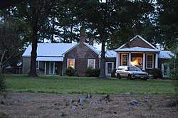 Hobson's Choice |
March 18, 1980 (#80004174) |
East of Alberta on Old Bridge Rd. 36°52′19″N 77°48′58″W |
Alberta | |
| 7 | Lawrenceville Historic District | 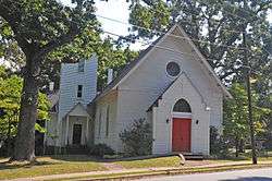 Lawrenceville Historic District |
April 13, 2000 (#00000313) |
Roughly bounded by W. 6th Ave., Maria St., the Lawrenceville town line, Rose Creek, and Thomas St. 36°45′29″N 77°50′50″W |
Lawrenceville | |
| 8 | Mason-Tillett House | 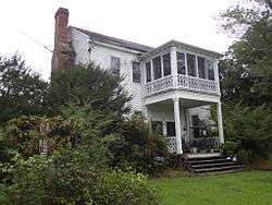 Mason-Tillett House |
January 16, 2004 (#03001443) |
1050 Christanna Highway 36°33′33″N 77°48′13″W |
Valentines | |
| 9 | Rocky Run Methodist Church | 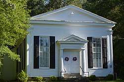 Rocky Run Methodist Church |
July 7, 1995 (#95000828) |
Lew Jones Rd., 1.8 miles (2.9 km) east of its junction with State Route 46 36°55′55″N 77°56′21″W |
Alberta | |
| 10 | St. Paul's College |  St. Paul's College |
June 27, 1979 (#79003032) |
St. Paul's College campus 36°45′40″N 77°50′59″W |
Lawrenceville | |
| 11 | St. Paul's School | 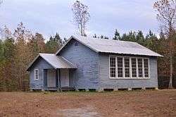 St. Paul's School |
June 4, 2004 (#04000037) |
Brunswick Dr. at Interstate 85 36°49′31″N 77°57′30″W |
Meredithville |
Former listing
| [3] | Name on the Register | Image | Date listed | Date removed | Location | City or town | Summary |
|---|---|---|---|---|---|---|---|
| 1 | Bentfield | January 24, 1974 (#74002109) | March 19, 2001 | SW of Lawrenceville off U.S. 58 and VA 656 |
Lawrenceville | Destroyed by fire in 1974 |
See also
| Wikimedia Commons has media related to National Register of Historic Places in Brunswick County, Virginia. |
References
- The latitude and longitude information provided in this table was derived originally from the National Register Information System, which has been found to be fairly accurate for about 99% of listings. Some locations in this table may have been corrected to current GPS standards.
- "National Register of Historic Places: Weekly List Actions". National Park Service, United States Department of the Interior. Retrieved on June 19, 2020.
- Numbers represent an ordering by significant words. Various colorings, defined here, differentiate National Historic Landmarks and historic districts from other NRHP buildings, structures, sites or objects.
- "National Register Information System". National Register of Historic Places. National Park Service. April 24, 2008.
- The eight-digit number below each date is the number assigned to each location in the National Register Information System database, which can be viewed by clicking the number.
- PCT07A: Fort Christanna Historical Site, Virginia Department of Game & Inland Fisheries, 2017. Accessed 2017-01-03.

Municipalities and communities of Brunswick County, Virginia, United States | ||
|---|---|---|
| Towns | Map of Virginia highlighting Brunswick County | |
| CDPs | ||
| Unincorporated communities |
| |
| Footnotes | ‡This populated place also has portions in an adjacent county or counties | |
This article is issued from Wikipedia. The text is licensed under Creative Commons - Attribution - Sharealike. Additional terms may apply for the media files.