National Register of Historic Places listings in Rockbridge County, Virginia
This is a list of the National Register of Historic Places listings in Rockbridge County, Virginia.
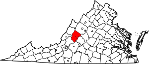
Location of Rockbridge County in Virginia
This is intended to be a complete list of the properties and districts on the National Register of Historic Places in Rockbridge County, Virginia, United States. The locations of National Register properties and districts for which the latitude and longitude coordinates are included below, may be seen in an online map.[1]
There are 48 properties and districts listed on the National Register in the county, including 2 National Historic Landmarks.
- This National Park Service list is complete through NPS recent listings posted June 26, 2020.[2]
Current listings
| [3] | Name on the Register[4] | Image | Date listed[5] | Location | City or town | Description |
|---|---|---|---|---|---|---|
| 1 | Anderson Hollow Archaeological District | 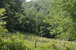 Anderson Hollow Archaeological District |
July 21, 1983 (#83003314) |
Western side of Big Hill Rd.[6] 37°51′06″N 79°35′02″W |
Lexington | |
| 2 | Boxerwood | 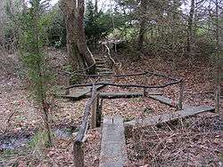 Boxerwood |
June 4, 2015 (#15000254) |
963 Ross Rd. 37°46′36″N 79°27′54″W |
Lexington | |
| 3 | Brownsburg Historic District |  Brownsburg Historic District |
July 2, 1973 (#73002055) |
Including the entire village extending 0.5 miles (0.80 km) along State Route 252 37°55′43″N 79°19′09″W |
Brownsburg | |
| 4 | Buffalo Forge (081-0003) | 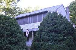 Buffalo Forge (081-0003) |
May 26, 2004 (#04000551) |
2694 Forge Rd. 37°41′11″N 79°26′06″W |
Glasgow | |
| 5 | Cedar Hill |  Cedar Hill |
July 15, 1994 (#94000726) |
Eastern side of Forge Rd., 2.25 miles (3.62 km) south of its junction with U.S. Route 60 37°43′05″N 79°23′57″W |
Buena Vista | |
| 6 | Cedar Hill Church and Cemeteries | 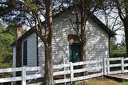 Cedar Hill Church and Cemeteries |
February 11, 2002 (#01001570) |
Cedar Hill Church Rd. and Kygers Hill Rd. 37°44′31″N 79°31′34″W |
Lexington | |
| 7 | Chapel Hill |  Chapel Hill |
June 8, 2011 (#11000350) |
68 Charming Ln. 37°43′14″N 79°24′45″W |
Lexington | |
| 8 | Church Hill |  Church Hill |
February 26, 1979 (#79003079) |
6.5 miles (10.5 km) northeast of Lexington off U.S. Route 11 at Interstate 64 37°50′31″N 79°21′32″W |
Lexington | |
| 9 | Clifton | 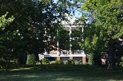 Clifton |
July 22, 1994 (#94000778) |
Northern side of Old Buena Vista Rd., 2,000 feet (610 m) east of its junction with U.S. Route 11 37°47′29″N 79°25′07″W |
Lexington | |
| 10 | Echols Farm |  Echols Farm |
October 30, 1998 (#98001312) |
Junction of U.S. Route 501 and State Route 130 37°37′47″N 79°26′28″W |
Glasgow | |
| 11 | Falling Spring Presbyterian Church Manse | 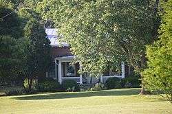 Falling Spring Presbyterian Church Manse |
November 16, 2005 (#05001269) |
650 Falling Spring Rd. 37°41′00″N 79°27′34″W |
Glasgow | |
| 12 | Fancy Hill | 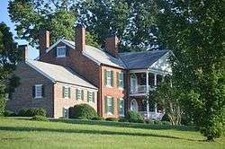 Fancy Hill |
September 5, 1997 (#97000957) |
Junction of U.S. Route 11 and Falling Spring Rd. 37°41′23″N 79°29′11″W |
Glasgow | |
| 13 | Glasgow Historic District | 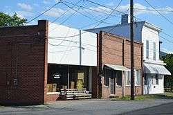 Glasgow Historic District |
October 30, 1995 (#95001170) |
Bounded by 7th, 10th, Gordon, and Powhatan Sts.; also the 900 blocks of Fizlee St. and Rockbridge Rd. 37°38′01″N 79°27′00″W |
Glasgow | Second set of boundaries represents a boundary increase of May 3, 2006 |
| 14 | Glen Maury |  Glen Maury |
May 24, 1979 (#79003078) |
West of Buena Vista 37°43′49″N 79°21′46″W |
Buena Vista | |
| 15 | Goshen Land Company Bridge | .jpg) Goshen Land Company Bridge |
May 15, 1978 (#78003041) |
East of Goshen on Paxton Dr. 37°59′08″N 79°29′38″W |
Goshen | |
| 16 | Haines Chapel and Cemetery | 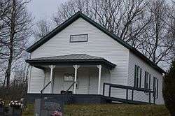 Haines Chapel and Cemetery |
February 10, 2014 (#13001174) |
2600 State Route 56 37°53′18″N 79°09′17″W |
Vesuvius | Extends into Nelson County |
| 17 | Hamilton Schoolhouse | 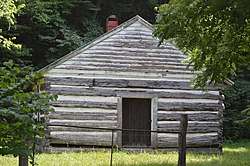 Hamilton Schoolhouse |
November 21, 2002 (#02001372) |
S. Buffalo Rd. 37°42′07″N 79°35′49″W |
Lexington | |
| 18 | Hays Creek Mill |  Hays Creek Mill |
August 4, 1995 (#95000973) |
Hays Creek Rd., 0.1 miles north of its junction with McElwee Rd. 37°56′08″N 79°20′38″W |
Brownsburg | |
| 19 | Hickory Hill | 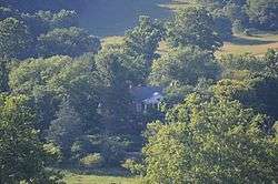 Hickory Hill |
August 30, 2006 (#06000760) |
197 Hickory Hill Ln. 37°39′55″N 79°28′43″W |
Glasgow | |
| 20 | Kennedy-Lunsford Farm |  Kennedy-Lunsford Farm |
June 7, 1996 (#96000592) |
Approximately 0.5 miles south of Raphine Rd. near its junction with Gibbs Run Ln.; also 1194 Raphine Rd. 37°56′13″N 79°16′05″W |
Raphine | 1194 Raphine represents a boundary increase of February 22, 1999 |
| 21 | Kennedy-Wade Mill |  Kennedy-Wade Mill |
July 13, 1979 (#79003296) |
2.3 miles northeast of Brownsburg on Raphine Rd.; also Raphine Rd., 2000 feet northeast of its junction with Goose Creek Rd. 37°56′57″N 79°17′10″W |
Raphine | Second set of boundaries represents a boundary increase of May 26, 1994, the Kennedy-Wade's Mill Historic District |
| 22 | Level Loop |  Level Loop |
August 12, 1993 (#93000822) |
Hays Creek Rd., 1 mile west of Brownsburg and 0.5 mile east of McClung's Mill 37°55′57″N 79°20′12″W |
Brownsburg | |
| 23 | Liberty Hall Site |  Liberty Hall Site |
August 16, 1977 (#77001493) |
West of the Washington and Lee University campus[7] 37°47′34″N 79°27′02″W |
Lexington | Site of predecessor of Washington and Lee University |
| 24 | Locust Hill |  Locust Hill |
May 12, 1986 (#86001066) |
Forge Rd. 37°43′55″N 79°24′03″W |
Mechanicsville | |
| 25 | William Mackey House |  William Mackey House |
October 29, 1993 (#93001126) |
Timber Ridge Rd., 0.5 miles southeast of its junction with U.S. Route 11 37°50′26″N 79°20′25″W |
Cornwall | |
| 26 | Maple Hall |  Maple Hall |
January 29, 1987 (#87000006) |
Junction of Interstates 64 and 81 with U.S. Route 11 37°50′33″N 79°21′51″W |
Lexington | |
| 27 | Marlbrook |  Marlbrook |
September 14, 2002 (#02001000) |
4973 Forge Rd. 37°38′48″N 79°29′56″W |
Glasgow | |
| 28 | Cyrus McCormick Farm and Workshop |  Cyrus McCormick Farm and Workshop |
October 15, 1966 (#66000846) |
South of Staunton on U.S. Route 11 and Raphine Rd. at Walnut Grove 37°55′54″N 79°12′52″W |
Steeles Tavern | |
| 29 | John Moore House |  John Moore House |
June 25, 1999 (#99000728) |
183 Big Hill Rd. 37°51′42″N 79°33′05″W |
Lexington | |
| 30 | Mountain View Farm |  Mountain View Farm |
January 27, 2000 (#99001723) |
199 Fredericksburg Rd. 37°51′50″N 79°29′02″W |
Lexington | |
| 31 | Mulberry Grove |  Mulberry Grove |
July 28, 1994 (#94000761) |
Southern side of Hays Creek Rd., 5000 feet southeast of its junction with State Route 252 37°55′24″N 79°18′22″W |
Brownsburg | |
| 32 | Natural Bridge |  Natural Bridge |
November 18, 1997 (#97001401) |
Junction of U.S. Route 11 and State Route 130 37°37′41″N 79°32′41″W |
Natural Bridge | |
| 33 | Natural Bridge Historic District | .jpg) Natural Bridge Historic District |
February 2, 2016 (#15001047) |
U.S. Route 11 and State Route 130 37°37′48″N 79°32′40″W |
Natural Bridge | |
| 34 | New Providence Presbyterian Church |  New Providence Presbyterian Church |
March 26, 1980 (#80004223) |
Northeast of Brownsburg 37°57′07″N 79°18′08″W |
Brownsburg | |
| 35 | Oak Spring Farm |  Oak Spring Farm |
October 19, 1994 (#94000780) |
Borden Grant Trail at its junction with U.S. Route 11 37°54′22″N 79°14′01″W |
Steeles Tavern | |
| 36 | Margaret E. Poague House |  Margaret E. Poague House |
March 29, 2007 (#07000236) |
4907 S. U.S. Route 11 37°39′41″N 79°30′36″W |
Lexington | |
| 37 | Rockbridge Alum Springs Historic District |  Rockbridge Alum Springs Historic District |
January 19, 1989 (#88003204) |
Off Rockbridge Alum Springs Rd.[8] 37°54′27″N 79°36′40″W |
California | |
| 38 | Rockbridge Inn |  Rockbridge Inn |
April 7, 1995 (#95000398) |
Northern side of Herring Hall Rd. at its junction with Rices Hill Rd. 37°39′19″N 79°32′15″W |
Natural Bridge | |
| 39 | Scott-Hutton Farm |  Scott-Hutton Farm |
August 28, 2017 (#100001516) |
1892 Turnpike Rd. 37°47′09″N 79°33′07″W |
Lexington | |
| 40 | Springdale | February 14, 2006 (#05001273) |
70 Gilmore Ln. 37°44′23″N 79°25′11″W |
Lexington | ||
| 41 | Stone House | .jpg) Stone House |
May 24, 1979 (#79003080) |
West of Lexington on Ross Rd. 37°46′31″N 79°27′35″W |
Lexington | |
| 42 | Sunnyside |  Sunnyside |
September 14, 2002 (#02001003) |
160 Kendal Dr. 37°46′48″N 79°27′38″W |
Lexington | |
| 43 | Tankersley Tavern |  Tankersley Tavern |
November 3, 1988 (#88002179) |
Furrs Mill Rd. 37°47′38″N 79°25′42″W |
Lexington | |
| 44 | Thorn Hill | .jpg) Thorn Hill |
June 18, 1975 (#75002035) |
Southwest of Lexington off State Route 251 37°45′49″N 79°27′54″W |
Lexington | |
| 45 | Timber Ridge Presbyterian Church |  Timber Ridge Presbyterian Church |
November 12, 1969 (#69000278) |
Southwest of the junction of U.S. Route 11 and Timber Ridge Rd. 37°50′34″N 79°21′30″W |
Lexington | |
| 46 | Vine Forest |  Vine Forest |
August 23, 1991 (#91001084) |
U.S. Route 11, 2 miles west of Natural Bridge 37°37′31″N 79°34′43″W |
Natural Bridge | |
| 47 | Virginia Manor |  Virginia Manor |
September 10, 1987 (#87001549) |
State Route 130 37°37′06″N 79°29′19″W |
Natural Bridge | |
| 48 | Willson House |  Willson House |
December 3, 2009 (#09001049) |
367 Wee Darnock Way 37°47′57″N 79°30′27″W |
Lexington |
See also
| Wikimedia Commons has media related to National Register of Historic Places in Rockbridge County, Virginia. |
References
- The latitude and longitude information provided in this table was derived originally from the National Register Information System, which has been found to be fairly accurate for about 99% of listings. Some locations in this table may have been corrected to current GPS standards.
- "National Register of Historic Places: Weekly List Actions". National Park Service, United States Department of the Interior. Retrieved on June 26, 2020.
- Numbers represent an ordering by significant words. Various colorings, defined here, differentiate National Historic Landmarks and historic districts from other NRHP buildings, structures, sites or objects.
- "National Register Information System". National Register of Historic Places. National Park Service. April 24, 2008.
- The eight-digit number below each date is the number assigned to each location in the National Register Information System database, which can be viewed by clicking the number.
- County of Rockbridge Comprehensive Plan 2016-2036, Rockbridge County, 2016, 12. Accessed 2016-12-24.
- Site Plans From the Liberty Hall Excavations: Site Plan 5, Washington and Lee University, 1974. Accessed 2016-12-24.
- Division of Historic Landmarks Staff. National Register of Historic Places Inventory/Nomination: Rockbridge Alum Springs Historic District. National Park Service, 1987, 26.

Municipalities and communities of Rockbridge County, Virginia, United States | ||
|---|---|---|
| Towns | Map of Virginia highlighting Rockbridge County | |
| CDP | ||
| Unincorporated communities | ||
| Footnotes | ‡This populated place also has portions in an adjacent county or counties | |
This article is issued from Wikipedia. The text is licensed under Creative Commons - Attribution - Sharealike. Additional terms may apply for the media files.