National Register of Historic Places listings in Danville, Virginia
This is a list of the National Register of Historic Places listings in Danville, Virginia.
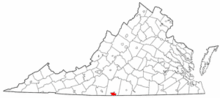
Location of Danville in Virginia
This is intended to be a complete list of the properties and districts on the National Register of Historic Places in the independent city of Danville, Virginia, United States. The locations of National Register properties and districts for which the latitude and longitude coordinates are included below, may be seen in an online map.[1]
There are 19 properties and districts listed on the National Register in the city. Another property was once listed but has been removed.
- This National Park Service list is complete through NPS recent listings posted June 26, 2020.[2]
Current listings
| [3] | Name on the Register[4] | Image | Date listed[5] | Location | Description |
|---|---|---|---|---|---|
| 1 | Dan River Mill No. 8 |  Dan River Mill No. 8 |
March 24, 2010 (#10000095) |
424 Memorial Dr. 36°35′30″N 79°23′41″W |
|
| 2 | Dan's Hill | 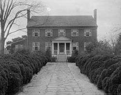 Dan's Hill |
May 30, 1979 (#79003067) |
4 miles (6.4 km) west of downtown Danville 36°35′29″N 79°28′41″W |
|
| 3 | Danville Historic District |  Danville Historic District |
April 11, 1973 (#73002207) |
Roughly bounded by Main, Green, and Paxton Sts., and Memorial Hospital; also Jefferson Ave., Chestnut Pl., Grove, Chambers, and the 100 blocks of Ross and Holbrook Sts. 36°34′55″N 79°24′00″W |
Second set of addresses represent a boundary increase of August 24, 2015 |
| 4 | Danville Municipal Building | 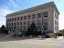 Danville Municipal Building |
July 21, 1995 (#95000896) |
418 Patton St. 36°35′11″N 79°23′31″W |
|
| 5 | Danville National Cemetery |  Danville National Cemetery |
April 7, 1995 (#95000274) |
721 Lee St. 36°34′37″N 79°23′22″W |
|
| 6 | Danville Public Library | 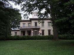 Danville Public Library |
November 12, 1969 (#69000338) |
975 Main St. 36°34′52″N 79°24′00″W |
|
| 7 | Danville Southern Railway Passenger Depot | 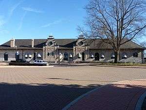 Danville Southern Railway Passenger Depot |
July 21, 1995 (#95000895) |
701 Craghead St. 36°35′03″N 79°23′02″W |
|
| 8 | Danville Tobacco Warehouse and Residential District |  Danville Tobacco Warehouse and Residential District |
July 14, 1982 (#82004552) |
Off U.S. Route 58 36°34′50″N 79°23′18″W |
Boundary increase May 21, 2009 |
| 9 | Downtown Danville Historic District | 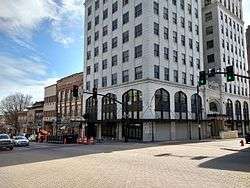 Downtown Danville Historic District |
August 12, 1993 (#93000830) |
Roughly bounded by Memorial Dr. and High, Patton, and Ridge Sts. 36°35′16″N 79°23′32″W |
|
| 10 | Holbrook-Ross Street Historic District |  Holbrook-Ross Street Historic District |
November 18, 1997 (#97001404) |
Roughly bounded by Holbrook, Ross, Gay, and Maury Sts. 36°35′12″N 79°24′10″W |
|
| 11 | Hotel Danville | 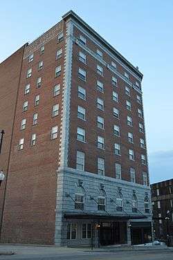 Hotel Danville |
December 6, 1984 (#84000658) |
600 Main St. 36°35′14″N 79°23′41″W |
|
| 12 | Hylton Hall |  Hylton Hall |
September 14, 2009 (#09000726) |
700 Lanier Ave. 36°34′04″N 79°25′34″W |
|
| 13 | Langhorne House | 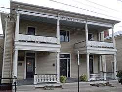 Langhorne House |
February 1, 2006 (#05001586) |
117 Broad St. 36°34′49″N 79°24′12″W |
|
| 14 | Main Street Methodist Episcopal Church South |  Main Street Methodist Episcopal Church South |
December 6, 1990 (#90001822) |
767 Main St. 36°35′05″N 79°23′47″W |
|
| 15 | Mechanicsville Historic District | 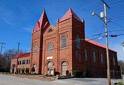 Mechanicsville Historic District |
May 19, 2014 (#14000231) |
Floyd, High, N. Ridge, Monroe, and Upper Sts. 36°35′20″N 79°23′47″W |
|
| 16 | North Danville Historic District | 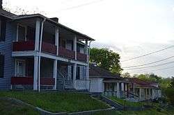 North Danville Historic District |
January 15, 2004 (#03001432) |
Roughly bounded by Riverside Dr., Claiborne St., the Leemont Cemetery, Novle Ave., and Scales St. 36°35′51″N 79°23′05″W |
|
| 17 | Penn-Wyatt House | 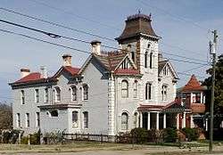 Penn-Wyatt House |
September 7, 1979 (#79003317) |
862 Main St. 36°35′00″N 79°23′56″W |
|
| 18 | Schoolfield School Complex | 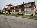 Schoolfield School Complex |
June 3, 2009 (#09000392) |
31 Baltimore Ave. 36°34′03″N 79°25′26″W |
|
| 19 | Schoolfield Welfare Building | 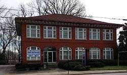 Schoolfield Welfare Building |
March 1, 2011 (#11000064) |
917 W. Main St. 36°34′09″N 79°25′27″W |
Former listings
| [3] | Name on the Register | Image | Date listed | Date removed | Location | Summary |
|---|---|---|---|---|---|---|
| 1 | Dan River Inc. Riverside Division Historic District | 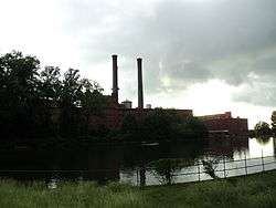 Dan River Inc. Riverside Division Historic District |
May 11, 2000 (#00000480) | July 29, 2016 | Both sides of Dan River roughly bounded by Union St. Dam, Main St. Bridge, and Riverside and Memorial Drs.; also 424 Memorial Dr. 36°35′34″N 79°23′50″W |
424 Memorial represents Dan River Mill No. 8, a boundary increase of March 24, 2010 |
See also
| Wikimedia Commons has media related to National Register of Historic Places in Danville, Virginia. |
References
- The latitude and longitude information provided in this table was derived originally from the National Register Information System, which has been found to be fairly accurate for about 99% of listings. Some locations in this table may have been corrected to current GPS standards.
- "National Register of Historic Places: Weekly List Actions". National Park Service, United States Department of the Interior. Retrieved on June 26, 2020.
- Numbers represent an ordering by significant words. Various colorings, defined here, differentiate National Historic Landmarks and historic districts from other NRHP buildings, structures, sites or objects.
- "National Register Information System". National Register of Historic Places. National Park Service. April 24, 2008.
- The eight-digit number below each date is the number assigned to each location in the National Register Information System database, which can be viewed by clicking the number.

This article is issued from Wikipedia. The text is licensed under Creative Commons - Attribution - Sharealike. Additional terms may apply for the media files.